Upper Seymour River Provincial Park is a provincial park in British Columbia, Canada. Located in an isolated area in the interior of the province, 40 kilometres north of the community of Seymour Arm. It protects at the headwaters of the Seymour River, which is the major drainage system into the Seymour Arm of Shuswap Lake.

Wadi Qelt, also Nahal Prat, formerly Naḥal Faran, is a valley, riverine gulch or stream in the West Bank, originating near Jerusalem and running into the Jordan River near Jericho and the Dead Sea.

The Albert Premier Hut, sometimes known as Albert 1er is located on the Haute Route between Chamonix, France and Zermatt, Switzerland. It is at 2,702 metres (8,865 ft) above sea level. It is a popular hut with day hikers because of the short hike and beautiful views, like those into Chamonix Valley. The hut is usually used less by hikers attempting the entire Haute Route, but is popular as a base for climbers attempting the Aiguille du Chardonnet and the Aiguille du Tour.

Cwmdu or Llanfihangel Cwmdu is a small village and community situated in the heart of the Black Mountains in Powys, Wales. Its name is derived from the Welsh language "Cwm Du", which means 'Black Valley'. It is located on the A479 Talgarth to Tretower road. Nearby towns include Crickhowell and Abergavenny. The population of the community, Llanfihangel Cwmdu with Bwlch and Cathedine, which includes Cwmdu and nearby villages Bwlch, Tretower and Cathedine, as of the 2011 UK Census was 1026. It is in the historic county of Brecknockshire.
The Lynn Valley Trail is a 10-kilometre (6.2 mi) trail connecting Simcoe, Ontario, Canada to Port Dover.

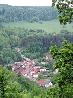
Sieber is a village in the borough of Herzberg am Harz in the district of Göttingen in South Lower Saxony (Germany).

Rübeland is a village in the district of Harz in the German state of Saxony-Anhalt. Since 2004, it has been given the additional description of Höhlenort. The sub-districts of Rübeland are Susenburg, Kaltes Tal, Kreuztal and Neuwerk. Since 1 January 2010, it is part of the town Oberharz am Brocken and has 959 inhabitants.
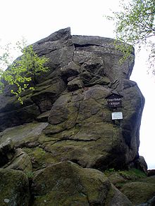
The Böser Kleef is a rock formation, 440 metres above sea level, near the village of Altenbrak in the district of Harz in central Germany. It is made largely of granite.
The Taubenklippe is a rock formation in the Harz mountains in the German state of Saxony-Anhalt. It lies about halfway between Bad Harzburg and Ilsenburg at a height of 572 m above NN on the eastern slopes of the Ecker valley. From the crag there is a good view over Harz Foreland, the heights near Bad Harzburg and the highest mountain in the Har, the Brocken. The Taubenklippe may be reached from the Ecker valley on a footpath, some 6 km long, that starts in Ilsenburg.
The Ottofels, named after Prince Otto of Stolberg-Wernigerode, is a tor and natural monument near Wernigerode in the Harz mountains of central Germany.

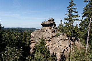
The Froschfelsen, also called the Froschsteinklippe, is a natural monument near Ilsenburg in the northern Harz in central Germany. It is a formation of granite rocks that take the shape of a frog, hence the name.

The Christianental is a side valley of the Mühlental in the borough of Wernigerode in the Harz Mountains of central Germany. It lies between the Agnesberg, the hill on which Wernigerode Castle stands, and the Fenstermacherberg. The Christianental is known countrywide for its wildlife park, the forest restaurant at the head of the valley along with the indoor shooting range (Schützenhaus) and the master fisherman's house (Fischmeisterhaus) and neighbouring forester's lodge at the bottom of the valley. The latter was featured in the title of the novel Das Forsthaus im Christianental by Käthe Papke.

The Molkenhaus near Bad Harzburg is a wooden house, built in 1822, where cattle from the hillside pastures used to be milked without having to be driven miles to the surrounding farms. The house was owned by the manor of Bündheim-Bad Harzburg and, today, has been extended into a popular restaurant for day trippers and hikers. The property lies on the shores of the Hasselteich pond, about 3 km (1.9 mi) south of Bad Harzburg east of the Rudolfklippe crags on a valley water meadow.
The Harplage is a hill range, up to 290 metres high, located west-northwest of the Harz in the southeast of the German state of Lower Saxony.

The Bremen Hut in the Harz Mountains is a refuge hut and shelter in that part of the Harz National Park lying within the borough of Ilsenburg (Harz) in Harz district in the German state of Saxony-Anhalt.

The Ilse valley is the ravine of the Ilse creek in the northern boundary of the Harz mountain range in Germany. Part of the Harz National Park, it runs from the town of Ilsenburg at the foot of the mountain range up to the source region near the summit of the Brocken massif, the highest mountain of the range. The scenic valley is a popular hiking area.

The Harz/Saxony-Anhalt Nature Park is situated n the districts of Harz and Mansfeld-Südharz in the German state of Saxony-Anhalt. The nature park which lies in the Harz Mountains was founded in 2003 and has an area of around 1,660 km². It is looked after by the Harz Regional Association.

The Barenberg, also called the Bärenberg or Bärenkopf, is a mountain, 695.5 m above sea level (NN), in the Harz Mountains of Germany near the village of Schierke, Harz county, in the state of Saxony-Anhalt.

The Kapitelsberg in the Harz Mountains of Germany is a hill, 535.7 m above sea level (NN), near the village of Tanne in the county of Harz, Saxony-Anhalt.