Flanders is the Dutch-speaking northern portion of Belgium and one of the communities, regions and language areas of Belgium. However, there are several overlapping definitions, including ones related to culture, language, politics, and history, and sometimes involving neighbouring countries. The demonym associated with Flanders is Fleming, while the corresponding adjective is Flemish. The official capital of Flanders is the City of Brussels, although the Brussels-Capital Region that includes it has an independent regional government. The powers of the government of Flanders consist, among others, of economic affairs in the Flemish Region and the community aspects of Flanders life in Brussels, such as Flemish culture and education.

A map is a symbolic depiction emphasizing relationships between elements of some space, such as objects, regions, or themes.
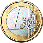
There are eight euro coin denominations, ranging from one cent to two euros. The coins first came into use in 2002. They have a common reverse, portraying a map of Europe, but each country in the eurozone has its own design on the obverse, which means that each coin has a variety of different designs in circulation at once. Four European microstates that are not members of the European Union use the euro as their currency and also have the right to mint coins with their own designs on the obverse side.

In modern mapping, a topographic map or topographic sheet is a type of map characterized by large-scale detail and quantitative representation of relief features, usually using contour lines, but historically using a variety of methods. Traditional definitions require a topographic map to show both natural and artificial features. A topographic survey is typically based upon a systematic observation and published as a map series, made up of two or more map sheets that combine to form the whole map. A topographic map series uses a common specification that includes the range of cartographic symbols employed, as well as a standard geodetic framework that defines the map projection, coordinate system, ellipsoid and geodetic datum. Official topographic maps also adopt a national grid referencing system.

The Battle of Fleurus, on 26 June 1794, was an engagement during the War of the First Coalition, between the army of the First French Republic, under General Jean-Baptiste Jourdan, and the Coalition army, commanded by Prince Josias of Coburg, in the most significant battle of the Flanders Campaign in the Low Countries during the French Revolutionary Wars. Both sides had forces in the area of around 80,000 men but the French were able to concentrate their troops and defeat the First Coalition. The Allied defeat led to the permanent loss of the Austrian Netherlands and to the destruction of the Dutch Republic. The battle marked a turning point for the French army, which remained ascendant for the rest of the War of the First Coalition.

Swisstopo is the official name for the Swiss Federal Office of Topography, Switzerland's national mapping agency.

Gau is a Germanic term for a region within a country, often a former or current province. It was used in the Middle Ages, when it can be seen as roughly corresponding to an English shire. The administrative use of the term was revived as a subdivision during the period of Nazi Germany in 1933–1945. It still appears today in regional names, such as the Rheingau or Allgäu.
The Royal Library of Belgium is the national library of Belgium. The library has a history that goes back to the age of the Dukes of Burgundy. In the second half of the 20th century, a new building was constructed on the Mont des Arts/Kunstberg in central Brussels, near the Central Station. The library owns several collections of historical importance, like the Library of the Dukes of Burgundy, and is the depository for all books ever published in Belgium or abroad by Belgian authors.

The Duchy of Brabant was a state of the Holy Roman Empire established in 1183. It developed from the Landgraviate of Brabant and formed the heart of the historic Low Countries, part of the Burgundian Netherlands from 1430 and of the Habsburg Netherlands from 1482, until it was partitioned after the Dutch revolt.
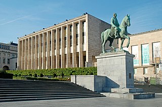
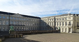
The Royal Palace of Brussels is the official palace of the King and Queen of the Belgians in the centre of the nation's capital, Brussels. However, it is not used as a royal residence, as the king and his family live in the Royal Palace of Laeken in northern Brussels. The website of the Belgian Monarchy describes the function of the Royal Palace as follows:
The Royal Palace is where His Majesty the King exercises his prerogatives as Head of State, grants audiences and deals with affairs of state. Apart from the offices of the King and the Queen, the Royal Palace houses the services of the Grand Marshal of the Court, the King's Head of Cabinet, the Head of the King's Military Household and the Intendant of the King's Civil List. The Royal Palace also includes the State Rooms where large receptions are held, as well as the apartments provided for foreign Heads of State during official visits.
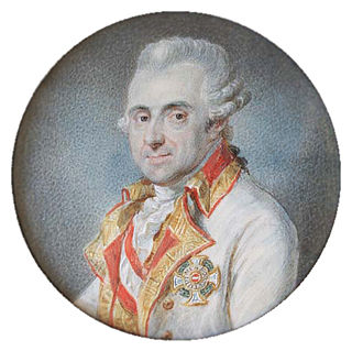
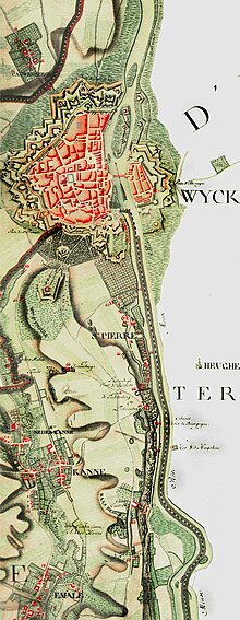
Joseph Jean François, count de Ferraris was an Austrian general and cartographer. He was married to the daughter of Charles, 2nd Duke d'Ursel.

A national mapping agency is an organisation, usually publicly owned, that produces topographic maps and geographic information of a country. Some national mapping agencies also deal with cadastral matters.

The United States Geological Survey (USGS), founded as the Geological Survey, is an agency of the United States government whose work spans the disciplines of biology, geography, geology, and hydrology. The agency was founded on March 3, 1879, to study the landscape of the United States, its natural resources, and the natural hazards that threaten it. The agency also makes maps of extraterrestrial planets and moons based on data from U.S. space probes.
The Palace of Charles of Lorraine is a neoclassical palace in the Royal Quarter of Brussels, Belgium. Its construction started in 1757 to serve as the residence of the Governor of the Habsburg Netherlands, Prince Charles Alexander of Lorraine, replacing the Palace of Orange-Nassau. It currently houses a museum, part of the Royal Library of Belgium (KBR).

A map series is a group of topographic or thematic charts or maps usually having the same scale and cartographic specifications, and with each sheet appropriately identified by its publisher as belonging to the same series.

A map collection or map library is a storage facility for maps, usually in a library, archive, or museum, or at a map publisher or public-benefit corporation, and the maps and other cartographic items stored within that facility.
The United States Geological Survey Library is a program within the United States Geological Survey, a scientific bureau within the Department of Interior of the United States government. The USGS operates as a fact-finding research organization with no regulatory responsibility.

The Battle of Gosselies or Battle of Charleroi saw a Republican French army co-commanded by Jacques Desjardin and Louis Charbonnier try to cross the Sambre River against a joint Dutch and Habsburg Austrian army under William, Hereditary Prince of Orange. The French defeat in the battle marked the third of five attempts by their armies to win a foothold on the north bank of the Sambre during the War of the First Coalition. In 1794, Gosselies was a separate village but is now part of the Charleroi municipality, about 7 kilometres (4 mi) north of the city center. Charleroi is located about 60 kilometres (37 mi) south of Brussels.

The Battle of Lambusart saw a Republican French army led by Jean Baptiste Jourdan try to cross the Sambre River against a combined Dutch and Habsburg Austrian army under William V, Hereditary Prince of Orange. This battle was the culmination of the fourth of five attempts to consolidate a foothold on the north side of the Sambre. The clash occurred during the War of the First Coalition, part of a wider struggle known as the Wars of the French Revolution. In 1794, Lambusart was an independent village, but it is now part of the Fleurus municipality. Lambusart is located about 10 kilometres (6 mi) northeast of Charleroi.

Château de Beurthé or Château de Steinbach is a castle situated in Steinbach, municipality of Gouvy, southeastern Belgium. Its park borders on the small river Steinbach, a tributary of the Ourthe Orientale.