
Libya is fourth in size among the countries of Africa and seventeenth among the countries of the world. It is on the Mediterranean between Egypt and Tunisia, with Niger and Chad to the south and Sudan to the southeast. Although the oil discoveries of the 1960s have brought immense wealth, at the time of its independence it was an extremely poor desert state whose only important physical asset appeared to be its strategic location at the midpoint of Africa's northern rim.

Fezzan or Phazania is the southwestern region of modern Libya. It is largely desert, but broken by mountains, uplands, and dry river valleys (wadis) in the north, where oases enable ancient towns and villages to survive deep in the otherwise inhospitable Sahara Desert. The term originally applied to the land beyond the coastal strip of Africa proconsularis, including the Nafusa and extending west of modern Libya over Ouargla and Illizi. As these Berber areas came to be associated with the regions of Tripoli, Cirta or Algiers, the name was increasingly applied to the arid areas south of Tripolitania. Fezzan is Libya’s poorest region.

Mohieddin Fikini, last name also spelled Fekini, was the Prime Minister of Libya from 19 March 1963 to 22 January 1964. He was also the Minister of foreign affairs from 19 March 1963 to 22 January 1964.
Hun or Houn is an oasis town in the northern Fezzan region of southwest Libya. The town is the capital of the Jufra District. The "International Autumn Tourism Festival", is an annual festival usually held at the end of September.

Italian Libya was a colony of the Kingdom of Italy located in North Africa, in what is now modern Libya. Italian Libya was formed from the Italian colonies of Cyrenaica and Tripolitania that were taken by the Kingdom of Italy from the Ottoman Empire in 1911, during the Italo-Turkish War of 1911 to 1912. The unified colony was established in 1934 by governor Italo Balbo, with Tripoli as the capital.
Italian Tripolitania was an Italian colony, located in present-day western Libya, that existed from 1912 to 1934. It was part of the Italian North African territory conquered from the Ottoman Empire in 1911. Italian Tripolitania included the western northern half of Libya, with Tripoli as its main city.

Tajarhi, Tegerhi or Tajirhi is an oasis and crossroads village in the Murzuq District of Libya. It lies in the Sahara Desert and is the last refueling point in Libya before reaching Madama, the first station in Niger, some 282 kilometers to the south, or 361 km by track. Tajarhi has an airstrip (HL-57) south of town.
Sokna is a Saharan desert oasis town in the Fezzan region of southwest Libya.
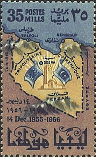
This is a survey of the postage stamps and postal history of Libya. Libya is a country located in North Africa. Bordering the Mediterranean Sea to the north, Libya lies between Egypt to the east, Sudan to the southeast, Chad and Niger to the south, and Algeria and Tunisia to the west.
Umm al Rizam is a town in eastern Libya. It is located some 48 km (30 mi) south of Derna. It is linked to Ras et Teen beach by a road which is 16 km (10 mi) long.
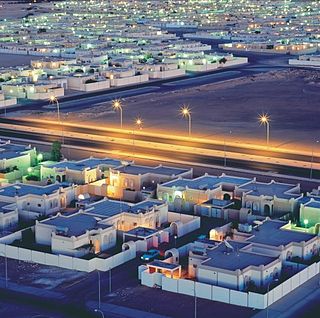
Sebha or Sebha is a Saharan desert oasis town in the Fezzan region of southwest Libya. It is close to the capital of the Sabha District, Sabha.
Tacnis or Taknis, Tècnis, also is a small town in Jebel Akhdar region in north eastern Cyrenaica, Libya. It's located 127 km (79 mi) east of Benghazi. It is on the inner road between Marj and Lamluda. There is a minor road connecting the town to the north with Libyan Coastal Highway. There also an indirect road connecting it with Charruba to the south.

Al Fejeij, or Al Fjeij is an oasis in southwestern Libya. It is located 52 km (32 mi) east of Ubari, on the crossroads between Sabha-Ubari road, and the south road to Tesawa, and Murzuk.
Zwila, also Zuila, Zweila, Zawila, Zawilah or Zuweila, is a village in southwestern Libya.

The 4th Shore, in Italian Quarta Sponda, was the name created by Benito Mussolini to refer to the Mediterranean shore of coastal colonial Italian Libya and WW II Italian Tunisia in the fascist era Kingdom of Italy, during the late Italian Colonial Empire period of Libya and the Maghreb.
Msus or Zawiyat Msus, also Masous is a village in eastern Libya. It's located 130 km (81 mi) on the southeast of Benghazi, and far from Suluq on the same direction by 80 km (50 mi).

Alexandria is the second-largest city in Egypt and a major economic centre, extending about 32 km (20 mi) along the coast of the Mediterranean Sea in the north central part of the country. Its low elevation on the Nile delta makes it highly vulnerable to rising sea levels. Alexandria is an important industrial center because of its natural gas and oil pipelines from Suez. Alexandria is also a popular tourist destination.

Cologne is the largest city of Germany's most populous federal state of North Rhine-Westphalia, and its 1 million+ (2016) inhabitants make it the fourth most populous city in Germany after Berlin, Hamburg, and Munich. The largest city on the Rhine, it is also the most populous city both of the Rhine-Ruhr Metropolitan Region, which is Germany's largest and one of Europe's major metropolitan areas, and of the Rhineland. Centred on the left bank of the Rhine, Cologne is about 45 kilometres (28 mi) southeast of North Rhine-Westphalia's capital of Düsseldorf and 25 kilometres (16 mi) northwest of Bonn. It is the largest city in the Central Franconian and Ripuarian dialect areas.

Germany, officially the Federal Republic of Germany, is a country in Central and Western Europe, lying between the Baltic and North Seas to the north, and the Alps to the south. It borders Denmark to the north, Poland and the Czech Republic to the east, Austria and Switzerland to the south, France to the southwest, and Luxembourg, Belgium and the Netherlands to the west.


