
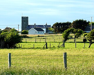
Llanrhystud is a seaside village and electoral division on the A487 road in the county of Ceredigion, in Wales, 9 miles (14 km) south of Aberystwyth, and 7 miles (11 km) north of Aberaeron. It takes its name from an early Welsh saint. The community includes the village of Llanddeiniol.

The Black Mountains are a group of hills spread across parts of Powys and Monmouthshire in southeast Wales, and extending across the England–Wales border into Herefordshire. They are the easternmost of the four ranges of hills that comprise the Brecon Beacons national park, and are frequently confused with the westernmost, which is known as the Black Mountain. The Black Mountains may be roughly defined as those hills contained within a triangle defined by the towns of Abergavenny in the southeast, Hay-on-Wye in the north and the village of Llangors in the west. Other gateway towns to the Black Mountains include Talgarth and Crickhowell. The range of hills is well known to walkers and ramblers for the ease of access and views from the many ridge trails, such as that on the Black Hill in Herefordshire, at the eastern edge of the massif. The range includes the highest public road in Wales at Gospel Pass, and the highest point in southern England at Black Mountain.
Aberarth is a village in Ceredigion, Wales, in the community of Dyffryn Arth, on the southern end of Cardigan Bay between Aberystwyth and Cardigan at the mouth of the River Arth on the A487 road. The Wales Coast Path passes through the village.

The A499 road is the major road of the Llŷn peninsula in North Wales.

The A482 road is in Ceredigion and Carmarthenshire, Wales. It links Aberaeron at the junction with the A487 road with the A40 road at Llanwrda near Llandovery. It is 29 miles (47 km) long.
The Plynlimon and Hafan Tramway was a 2 ft 3 in gauge narrow gauge railway in Cardiganshire in Mid Wales. It ran from Llanfihangel station on the Cambrian Line, through the village of Tal-y-bont and the valley of the Afon Leri, into the foothills of Plynlimon Fawr. It was built to serve the lead mines at Bwlch Glas and stone quarries around Hafan and opened in 1897, closing just two years later. The line was a little over 7 miles (11 km) long and, despite running a short-lived passenger service, it served no communities of more than 100 people.
Nelson is a village and community in the County Borough of Caerphilly, Wales. It sits five miles north of Caerphilly and ten miles north of Cardiff, at the lower end of the Taff Bargoed Valley, and lies adjacent to Treharris, Trelewis and Quakers Yard.

Capel-y-ffin is a hamlet near the English-Welsh border, a couple of miles north of Llanthony in Powys, Wales. It lies within the Black Mountains and within the Brecon Beacons National Park. The nearest town is Hay-on-Wye, some 8 miles (13 km) to the northwest.

The A498 is a 16-mile road between Pen-y-Gwryd and Porthmadog in North Wales.
Lôn Eifion is part of Lôn Las Cymru, the Welsh National Cycle Route, which is about 400 km (250 mi) long.

The Ffos-y-fran Land Reclamation Scheme was a major opencast coaling operation to the north-east of Merthyr Tydfil in South Wales. It was the last major opencast mine in the UK, and it shut down in November 2023 with restoration planned to start in 2024.

The Vale of Ewyas is the steep-sided and secluded valley of the River Honddu, in the Black Mountains of Wales and within the Brecon Beacons National Park. As well as its outstanding beauty, it is known for the ruins of Llanthony Priory, and for several noteworthy churches such as those at Capel-y-ffin and Cwmyoy. It is sometimes referred to as the "Llanthony Valley" as Llanthony is the village situated at the valley centre.
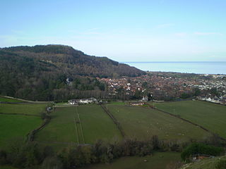
Castell Cawr, or Tan-y-Gopa as it is known locally, is a heavily forested hill above the town of Abergele in Conwy county borough, Wales. On it is found the Iron Age hillfort of Castell Cawr, which overlooks the River Clwyd. Rare lesser horseshoe bats inhabit caves on the hill. The woods are owned by the Woodland Trust. The hill rises to 189 m (620 ft) above sea level, with extensive views to Snowdonia and the Clwydian Range.

Ffos Las is a rural area between the villages of Carway and Trimsaran, north of the town of Llanelli in the Gwendraeth Valley in Carmarthenshire, Wales.

Rhydypennau is a hamlet in the Genau'r-glyn district of Ceredigion, Wales, approximately 4+1⁄2 miles (7.2 km) north-east of Aberystwyth. Along with the village of Pen-y-garn, Rhydypennau is now often considered to be part of the neighbouring village of Bow Street. All three places stretch in a long narrow strip along the main Aberystwyth to Machynlleth road (A487).
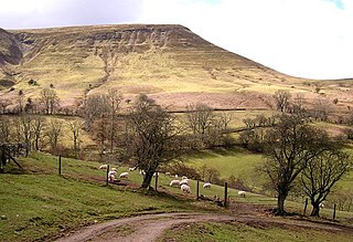
Twmpa or Lord Hereford's Knob is a mountain in south-east Wales, forming a part of the great northwest scarp of the Black Mountains. It lies 1.86 miles (3 km) west of the border with England, and around 4.34 miles (7 km) south of Hay-on-Wye. To the northeast lies the Gospel Pass through which runs a minor road between Hay and the Llanthony Valley. A ridge known as Darren Lwyd tapers away for about 3 kilometres (1.9 mi) to the southeast of the summit.
Castell Gwallter, also known as Walter's Castle and sometimes Castell Penweddig, is the remains of a Norman motte-and-bailey castle situated on a large hill above the old village of Llandre in northern Ceredigion, Wales, four miles northeast of Aberystwyth.
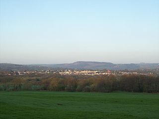
Llansantffraid or Llansantffraed is a small rural village and community and practically merged with the village of Llanon just west of the main A487 coastal road between Aberaeron and Aberystwyth, about 11 mi (18 km) from Aberystwyth. The population in 2001 was 1,241, declining to 1,212 at the 2011 census.
Henfynyw is a village and community in the county of Ceredigion, Wales, just outside Aberaeron, and is 69.6 miles (111.9 km) from Cardiff and 183.5 miles (295.4 km) from London. In 2011 the population of Henfynyw numbered 1045, with 54.3% of them able to speak Welsh. The community includes the villages of Ffos-y-ffin, Llwyncelyn and Derwen-gam

Fishguard and Goodwick is the name of a community that wraps around Fishguard Bay, on the northern coast of Pembrokeshire, Wales. It comprises the two towns of Fishguard and Goodwick, with their neighbourhoods of Dyffryn, Harbour Village, Penyraber, Lower Town, and Stop-and-Call. Within the community are two railway stations and Goodwick Ferry Terminal, which is the terminus of the A40 London to Fishguard Trunk Road.