Fiddler's Island

Last updated

The Thames Path on Fiddler's Island The Thames Path on Fiddler's Island - geograph.org.uk - 1758537.jpg
The Thames Path on Fiddler's Island

Fiddler's Island is an island in the River Thames at Oxford in England. It is situated south of Port Meadow on the reach above Osney Lock.

Contents

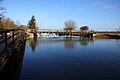
The north part of the island sits between the River Thames and the top end of Castle Mill Stream, a Thames backwater. Fiddler's Island Stream flows to the east of the southern part of the island. To the south of the island, there is a short stretch of water known as the Sheepwash Channel linking back to the Castle Mill Stream and the Oxford Canal. [2] The Thames Path runs the length of the complete island. At the northern end, the island has a row of trees along it. On the Castle Mill Stream side there is extensive mooring. The rainbow-shaped Medley Footbridge crosses the main stream of the Thames to the west at the northern end and a flat iron Bailey bridge crosses Castle Mill Stream further south, linking it to Port Meadow to the east. A small footbridge takes the Thames Path along the bank towards Osney Bridge. The northern part of Fiddler's Island is very thin. [3] The southern part, connected by a footbridge, is wider. [4] To the east is Cripley Meadow, largely consisting of allotments.

Fiddler's Island was authorised for public bathing by the Oxford City Council in 1852, probably the first place in Oxford to be approved by the council. [5]

See also

Related Research Articles

This article lists the islands in the River Thames, or at the mouth of a tributary, in England. It excludes human-made islands built as part of the building of forty-five two-gate locks which each accompany a weir, and islets subordinate to and forming part of the overall shape of another. The suffix -ey is common across England and Scotland and cognate with ait and meaning island, a term – as ait or eyot – unusually well-preserved on the Thames. A small minority of list entries are referred to as Island, Ait or Eyot and are vestiges, separated by a depression in the land or high-water-level gully.

Port Meadow, Oxford Meadow in Oxford

Port Meadow is a large meadow of open common land beside the River Thames to the north and west of Oxford, England.

Cookham Lock lock and weirs on the River Thames in Berkshire, England

Cookham Lock is a lock with weirs situated on the River Thames near Cookham, Berkshire, about a half-mile downstream of Cookham Bridge. The lock is set in a lock cut which is one of four streams here and it is surrounded by woods. On one side is Sashes Island and on the other is Mill Island connected to Formosa Island, the largest on the non-tidal Thames.

Thames Path National Trail following the River Thames in England

The Thames Path is a National Trail following the River Thames from its source near Kemble in Gloucestershire to the Thames Barrier at Charlton, south east London. It is about 184 miles (296 km) long. A path was first proposed in 1948 but it only opened in 1996.

Osney Human settlement in England

Osney or Osney Island is a riverside community in the west of the city of Oxford, England. In modern times the name is applied to a community also known as Osney Town astride Botley Road, just west of the city's main railway station, on an island surrounded by the River Thames, Osney Ditch and another backwater connecting the Thames to Osney Ditch.

Iffley Lock lock on the River Thames in Oxfordshire, England

Iffley Lock is a lock on the River Thames in England near the village of Iffley, Oxfordshire. It is on the southern outskirts of Oxford. The original lock was built by the Oxford-Burcot Commission in 1631 and the Thames Navigation Commission replaced this in 1793. The lock has a set of rollers to allow punts and rowing boats to be moved between the water levels.

Botley Road

Botley Road is the main road into the centre of Oxford, England from the west. It stretches between Botley, on the Oxford Ring Road (A34) to the west of the city, and Frideswide Square at the junction with Oxford railway station, close to central Oxford.

Osney Bridge

Osney Bridge is a road bridge across the River Thames in Oxford, England, built in 1888 to replace a stone bridge which collapsed in 1885. It carries the Botley Road (A420) from Botley into Oxford. The Thames Path crosses the river on this bridge, just above Osney Lock.

Osney Lock lock on the River Thames in Oxfordshire, England

Osney Lock is a lock on the River Thames in Oxford, England, where the village or island of Osney is next to the river.

Castle Mill Stream Stream in Oxfordshire, England

Castle Mill Stream is a backwater of the River Thames in the west of Oxford, England. It is 5.5 km long.

Medley Footbridge

Medley Footbridge is a pedestrian bridge across the River Thames near the village of Binsey in Oxford, England. It is also known as Rainbow Bridge, although there is another bridge of that name in the University Parks in Oxford.

Swift Ditch

The Swift Ditch is a 2 km (1.2 mi) long channel that formed a short cut for river traffic to and from Oxford, across a meander of the River Thames in England. It was formerly the primary navigation channel. With the main river, it creates Andersey Island on the left bank of the Thames opposite Abingdon-on-Thames. Within a poem published in 1632, the Water Poet John Taylor wrote:

At Abingdon the shoals are worse and worse
That Swift Ditch seems to be the better course

Mill Street, Oxford

Mill Street is a street in Oxford, England. It is a cul-de-sac that runs south from the Botley Road close to Oxford railway station. It includes residential houses, mainly terraced, and some office space. Mill Street was built in the 1860s as part of the development of New Osney on what was then known as Osney Island.

Walton Well Road

Walton Well Road is a road, about 400 metres long, near the centre of Oxford, England. It provides a link from central Oxford to Port Meadow.

Bulstake Stream Stream in Oxfordshire, England

Bulstake Stream, also spelt Bullstake Stream, is a backwater of the River Thames at Oxford, England.

Sheepwash Channel

Sheepwash Channel connects the River Thames to the west and the Castle Mill Stream next to the Oxford Canal to the east, in west Oxford, England. To the north are Cripley Meadow and Fiddler's Island. To the south are Osney Island and the Botley Road.

Isis Lock

Isis Lock is a lock connecting the Oxford Canal and the Castle Mill Stream, a backwater of the River Thames in Oxford, England.

Rewley Road Swing Bridge

Rewley Road Swing Bridge is a disused railway swing bridge over Sheepwash Channel in west Oxford, England. To the north are Cripley Meadow and Fiddler's Island and to the south are Osney Island and the Botley Road.

Sheepwash Channel Railway Bridge

Sheepwash Channel Railway Bridge is a railway bridge over Sheepwash Channel in west Oxford, England, just north of Oxford railway station. To the north are Cripley Meadow and Fiddler's Island. To the south are Osney Island and the Botley Road.

Cripley Meadow Human settlement in England

Cripley Meadow lies between the Castle Mill Stream, a backwater of the River Thames, and the Cotswold Line railway to the east, and Fiddler's Island, on the main branch of the Thames to the west, in Oxford, England. It is to the south of the better known Port Meadow, a large meadow of common land. To the south is Sheepwash Channel which connects the Oxford Canal with the River Thames.

References

  1. "Oxford to Northmoor". Thames Path National Trail. UK. Retrieved 18 September 2012.
  2. "River Thames (Sheepwash Channel)". UK: CanalPlanAC. Retrieved 15 September 2012.
  3. "Fiddler's Island (Oxford) (north)". Wikimapia . Retrieved 18 September 2012.
  4. "Fiddler's Island (Oxford) (south)". Wikimapia. Retrieved 18 September 2012.
  5. Crossley, Alan (1939). Salzman, Louis Francis; Page, William (eds.). The Victoria history of the county of Oxford. Victoria history of the counties of England. Vol. 4. Oxford University Press for University of London, Institute of Historical Research. p. 428.
Next island upstream River Thames Next island downstream
-Fiddler's Island Osney Island

Coordinates: 51°45′49″N1°16′48″W / 51.7635°N 1.2799°W / 51.7635; -1.2799