
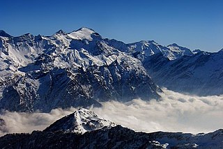
The Alpine region of Switzerland, conventionally referred to as the Swiss Alps, represents a major natural feature of the country and is, along with the Swiss Plateau and the Swiss portion of the Jura Mountains, one of its three main physiographic regions. The Swiss Alps extend over both the Western Alps and the Eastern Alps, encompassing an area sometimes called Central Alps. While the northern ranges from the Bernese Alps to the Appenzell Alps are entirely in Switzerland, the southern ranges from the Mont Blanc massif to the Bernina massif are shared with other countries such as France, Italy, Austria and Liechtenstein.

The Grisons or Graubünden, more formally the Canton of the Grisons or the Canton of Graubünden, is one of the twenty-six cantons of Switzerland. It has eleven districts, and its capital is Chur. The German name of the canton, Graubünden, translates as the "Grey Leagues", referring to the canton's origin in three local alliances, the Three Leagues. The other native names also refer to the Grey League: Grischùn in Sutsilvan, Grischun in the other forms of Romansh, and Grigioni in Italian. Rhaetia is the Latin name for the area. The Alpine ibex is the canton's heraldic symbol.

The Engadin or Engadine is a long high Alpine valley region in the eastern Swiss Alps in the canton of Graubünden in southeasternmost Switzerland with about 25,000 inhabitants. It follows the route of the Inn from its headwaters at Maloja Pass in the southwest running roughly northeast until the Inn flows into Austria, little less than one hundred kilometers downstream. The En/Inn subsequently flows at Passau into the Danube, making it the only Swiss river to drain into the Black Sea. The Engadine is protected by high mountain ranges on all sides and is famous for its sunny climate, beautiful landscapes and outdoor activities.

The Silvretta Alps are a mountain range of the Central Eastern Alps shared by Tirol, Vorarlberg and Graubünden (Switzerland). The Austrian states of Tirol and Vorarlberg are connected by a pass road. The majority of the peaks are elevated above three thousand metres and are surrounded by glaciers. Thus, the area is also known as the "Blue Silvretta".

The Central Eastern Alps, also referred to as Austrian Central Alps or just Central Alps, comprise the main chain of the Eastern Alps in Austria and the adjacent regions of Switzerland, Liechtenstein, Italy and Slovenia. South them is the Southern Limestone Alps.

The Samnaun Alps are a mountain range of the Central Eastern Alps, named after the Swiss municipality of Samnaun. They are located at the border of the Austrian state of Tyrol and the Graubünden canton of Switzerland.
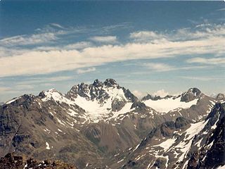
The Fluchthorn or Piz Fenga is a mountain in the Silvretta Alps, located on the border between Austria and Switzerland. With a height of 3,399 metres (11,152 ft) above sea level, it is the second highest summit of the Silvretta Alps. The Fluchthorn lies between the Jamtal (Tyrol) and the Val Fenga (Graubünden). It consists of three summits of which the southern one was the highest.

The Eastern Alps are usually defined as the area east of a line from Lake Constance and the Alpine Rhine valley, up to the Splügen Pass at the Alpine divide, and down the Liro River to Lake Como in the south. The peaks and mountain passes are lower than the Western Alps, while the range itself is broader and less arched.
The Rheinwaldhorn is the highest point in the Swiss canton of Ticino at 3,402 metres above sea level. It lies on the border between the cantons of Graubünden and Ticino, in the Adula massif, part of the St. Gotthard massif of the Adula Alps in southern Switzerland.

Val Poschiavo is a valley in the southern, Italian-speaking part of the Swiss canton of the Grisons. The main town is Poschiavo.

The Gamspleisspitze or Paraid Naira (Romansh) is a mountain of the Silvretta Alps, located on the border between Austria and Switzerland. From this peak, the border approaching south from the Fluchthorn departs east to intersect the neighboring valley in an Austrian lower (north) part named Fimbatal and an uninhabited Swiss upper (south) part, named Val Fenga. On the Austrian west site lies the also uninhabited Larein valley.
The Val Curciusa is an alpine valley in Graubünden, Switzerland. In the region of the San Bernardino Pass, it provides a connection between the Rheinwald valley and the Misox valley.

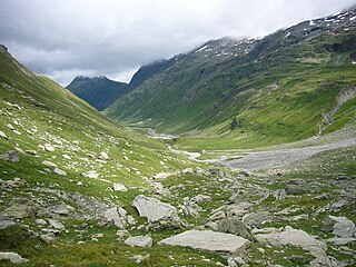
The Heidelberger Hut is a mountain hut located in the Silvretta in the Swiss canton of Graubünden. It lies at an altitude of 2,264 metres above sea level in the Val Fenga.
The Val Sinestra is a valley of the Swiss Alps, located in the Engadin between the Silvretta and the Samnaun ranges. The valley is drained by La Brancla, a tributary of the Inn basin, near Ramosch. The highest mountains in the Val Sinestra are the Muttler, Piz Tschütta and Piz Tasna. The valley is approximately 10 kilometres long.

The Val Russein is a valley of the Swiss Alps, located south of the Tödi Group in Graubünden. The valley is drained by the Aua da Russein, a tributary of the Vorderrhein, near Cumpadials. The Val Russein belongs to the municipalities of Disentis and Sumvitg.

The Val Roseg is a valley of the Swiss Alps, located on the north side of the Bernina Range in the canton of Graubünden (Engadin). The valley is drained by the Ova da Roseg, a tributary of the Flaz, at Pontresina. Most of the valley is part of an exclave of the municipality of Samedan. Only the bottom of Val Roseg lies in the municipality of Pontresina.

The Simplon Valley or Divedro Valley is a valley of the Alps, situated between the Pennine and the Lepontine ranges. The valley is drained by the Diveria or Chrummbach, a tributary of the Toce at Crevoladossola. The Simplon Valley is the only valley of Valais located south of the main chain of the Alps.

Val Fex is a southern side valley from the Upper Engadine in Switzerland, located at an altitude of around 1,800 to 2,000 metres above sea level. It belongs to the municipality of Sils im Engadin/Segl.
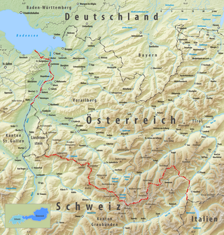
The border between the modern states of Austria and Switzerland is divided into two parts, separated by the Principality of Liechtenstein, with a total length of 180 km (110 mi). The longer, southern stretch runs across the Grison Alps and the shorter one following mostly the Alpine Rhine, except near Diepoldsau and between Lustenau and Lake Constance, where it follows the Old Rhine bed. The border continues northward to the Austrian-Swiss-German tripoint located within Upper Lake Constance.
Val Fedoz is a side valley of the Upper Engadin in the Swiss Canton of Grisons. Politically, it is part of the municipality of Bregaglia.
