The Bezirk Landeck is an administrative district (Bezirk) in Tyrol, Austria. It borders the district Reutte in the north, the district Imst in the east, South Tyrol (Italy) and Graubünden (Switzerland) in the south, and the district Bludenz (Vorarlberg) in the west.
Horgen District is a district of Canton of Zürich in Switzerland. The district is located in the Zimmerberg and Sihl Valley region; its capital is the town of Horgen. The district consists of 11 municipalities and has a population of 124,110 and an area of 104.16 km2 (40.22 sq mi).
Kulm District is a district in the canton of Aargau, Switzerland. It is located west of Lake Hallwil and covers parts of the Wyna and Suhre valleys. The principal town is Unterkulm; the largest municipality is Reinach. The district contains 17 municipalities, is 101.35 km² in area and has a population of 41,029.
Kreuzlingen District is one of the five districts of the canton of Thurgau in Switzerland. It has a population of 47,823. Its capital is the city of Kreuzlingen.
Olvio is a settlement in the municipality Topeiros in the Xanthi regional unit of Greece. It is located six kilometers north of Evlalos and 24 kilometers northeast of Xanthi. In 1981, the population of Olvio was around 518 inhabitants. In 1991, the population of the settlement rose to about 593 inhabitants.
Ellighausen is a village and former municipality in the canton of Thurgau, Switzerland.
Strohwilen is a village and former municipality in the canton of Thurgau, Switzerland.

Bettwiesen Castle is a castle in the municipality of Bettwiesen of the Canton of Thurgau in Switzerland. It is a Swiss heritage site of national significance.
Hauptwil Castle is a castle in the municipality of Hauptwil-Gottshaus of the Canton of Thurgau in Switzerland. It is a Swiss heritage site of national significance.
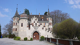
Seeburg Castle is a castle in the municipality of Kreuzlingen of the Canton of Thurgau in Switzerland. It is a Swiss heritage site of national significance.

Mammertshofen Castle is a castle in the municipality of Roggwil of the Canton of Thurgau in Switzerland. It is a Swiss heritage site of national significance.

Eugensberg Castle is a castle in the municipality of Salenstein of the Canton of Thurgau in Switzerland. It is a Swiss heritage site of national significance.

Louisenberg Castle is a castle in the municipality of Salenstein of the Canton of Thurgau in Switzerland. It is a Swiss heritage site of national significance.

Castell Castle is a castle in the municipality of Tägerwilen of the Canton of Thurgau in Switzerland. It is a Swiss heritage site of national significance.

Bachtobel Castle is a castle in the municipality of Weinfelden of the Canton of Thurgau in Switzerland. It is a Swiss heritage site of national significance.

Salenegg Castle is a castle in the municipality of Maienfeld of the Canton of Graubünden in Switzerland. It is a Swiss heritage site of national significance.

The Schwyz Alps are a mountain range in Switzerland. They form part of the North-Eastern Swiss Alps and are bordered by the Glarus Alps to the east, the Appenzell Alps to the north-east, the Emmental Alps in the west, and the Uri Alps to the south-west. The Klausen Pass is the highest point between the Schwyz Alps and the Glarus Alps.


