The transport system of Finland is well-developed. Factors affecting traffic include the sparse population and long distance between towns and cities, and the cold climate with waterways freezing and land covered in snow for winter.

Helsinki is the capital, primate, and most populous city of Finland. Located on the shore of the Gulf of Finland, it is the seat of the region of Uusimaa in southern Finland, and has a population of 656,250. The city's urban area has a population of 1,268,296, making it by far the most populous urban area in Finland as well as the country's most important center for politics, education, finance, culture, and research; while Tampere in the Pirkanmaa region, located 179 kilometres (111 mi) to the north from Helsinki, is the second largest urban area in Finland. Helsinki is located 80 kilometres (50 mi) north of Tallinn, Estonia, 400 km (250 mi) east of Stockholm, Sweden, and 300 km (190 mi) west of Saint Petersburg, Russia. It has close historical ties with these three cities.

A highway is any public or private road or other public way on land. It is used for major roads, but also includes other public roads and public tracks. In some areas of the United States, it is used as an equivalent term to controlled-access highway, or a translation for autobahn, autoroute, etc.

The international E-road network is a numbering system for roads in Europe developed by the United Nations Economic Commission for Europe (UNECE). The network is numbered from E1 up and its roads cross national borders. It also reaches Central Asian countries like Kyrgyzstan, since they are members of the UNECE.

Salo is a town and municipality of Finland. It is located in the Southwest Finland region. The municipality has a population of 51,563 and covers an area of 2,168.30 square kilometres (837.19 sq mi) of which 181.78 km2 (70.19 sq mi) is water. The population density is 25.96/km2 (67.2/sq mi). The municipality is unilingually Finnish.

European route E18 runs from Craigavon in Northern Ireland to Saint Petersburg in Russia, passing through Scotland, England, Norway, Sweden, and Finland. It is about 1,890 kilometres in length.

The Finnish railway network consists of a total track length of 9,216 km (5,727 mi) of railways built with 1,524 mm Old Russian gauge track having electrified track length of 3,249 km (2,019 mi). Passenger trains are operated by the state-owned VR which covers track length of 7,225 km (4,489 mi). They serve all the major cities and many rural areas, though railway connections are available to fewer places than bus connections. Most passenger train services originate or terminate at Helsinki Central railway station, and a large proportion of the passenger rail network radiates out of Helsinki. VR also operates freight services. Maintenance and construction of the railway network itself is the responsibility of the Finnish Rail Administration, which is a part of the Finnish Transport Agency. The network is divided in six areal centres, that manage the use and maintenance of the routes in co-operation. Cargo yards and large stations may have their own signalling systems.

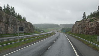
A controlled-access highway is a type of highway that has been designed for high-speed vehicular traffic, with all traffic flow—ingress and egress—regulated. Common English terms are freeway, motorway and expressway. Other similar terms include throughway and parkway. Some of these may be limited-access highways, although this term can also refer to a class of highway with somewhat less isolation from other traffic.

Länsiväylä is a motorway in the Greater Helsinki area of Finland, mainly at the Helsinki conurbation. It is part of the Finnish national road 51. The road begins in Ruoholahti in western Helsinki and continues west through the island of Lauttasaari and then across the city border to Espoo. The Länsiväylä road continues all the way throughout the southern part of Espoo. It continues as a motorway until finally crossing the border west to Kirkkonummi.
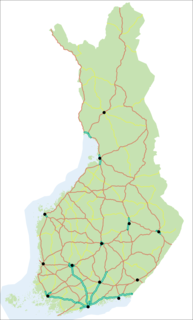
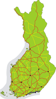
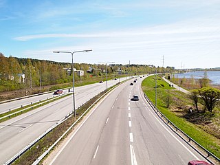
Roads in Finland comprise 78,141 kilometres (48,555 mi) of highways, paved and gravel roads which are divided in four to five classes according to their local importance.

Although Finland has no dedicated high-speed rail lines, sections of its rail network are capable of running speeds of 200 km/h (120 mph). The Finnish national railway company VR operates tilting Alstom Pendolino trains. The trains reach their maximum speed of 220 km/h in regular operation on a 75.7 km (47.0 mi) route between Kerava and Lahti. This portion of track was opened in 2006. The trains can run at 200 km/h (120 mph) on a longer route between Helsinki and Seinäjoki and peak at that speed between Helsinki and Turku. The main railway line between Helsinki and Oulu has been upgraded between Seinäjoki and Oulu to allow for trains to run at speeds between 160 km/h (99 mph) and 200 km/h (120 mph). Other parts of the Finnish railway network are limited to lower speed.
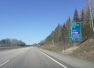
Finnish national road 3 is a highway in Finland between Helsinki and Vaasa via Hämeenlinna and Tampere. The road is 424 kilometres (263 mi) long and it is part of the European route E12. 180 kilometres (110 mi) of the highway is motorway, connecting Helsinki to Tampere. North of Tampere, the road is mostly two-lane road, with a share of 2+1 road. The busiest point on Highway 3 is in Helsinki, north of the Ring I junction, where the average traffic volume is about 90,000 vehicles per day.
Finnish national road 7 is a highway in Finland. It runs from Erottaja in Helsinki to the Russian frontier at the Vaalimaa border crossing point in Virolahti. The road is 189 kilometres (117 mi) long. The road is also European route E18 and it is a part of TERN.

Highways in Finland, or Main roads, comprise the highest categories of roads in Finland:

The Tampere Ring Road or former Finnish National Road 60 is a ring road in Tampere sub-region, Finland. It leads from Ylöjärvi to Tampere, passing by Nokia and Pirkkala. Its western part forms part of Highway 3, while its eastern part forms part of Highway 9.

The Helsinki–Turku high-speed railway or tunnin juna, also formerly known as the ELSA-rata (Espoo-Lohja-Salo), is a proposed railway line in the planning stage to provide a more direct connection between Helsinki and Turku, Finland than the current Rantarata railway line which follows the southern coast.
The Finnish national road 9 is the main route. It runs from Turku through Loimaa, Tampere, Jämsä, Jyväskylä, Kuopio, Outokumpu and Joensuu to the Niirala border guard station in Tohmajärvi, right next to the Russian border. The length of the road is 663 kilometres (412 mi).

Muijala is a district in Lohja, Finland. It is located northeast of the city center of Lohja along the connecting road 1125 and the Hyvinkää–Karjaa railway between the Turku Highway and the Hanko Highway. The driving time from Muijala to Helsinki along the Turku highway is about 45 minutes and buses run to Helsinki every 15-50 minutes during peak hours. The easternmost area of Muijala is an industrial area called Muijalannummi.

Finnish regional road 110, or Turku Road, is the leading regional road from Helsinki to Turku. The road is a parallel to the former Highway 1 and the current Highway 1 (E18).