
Fiordland, is a non-administrative geographical region of New Zealand in the south-western corner of the South Island, comprising the western third of Southland. Most of Fiordland is dominated by the steep sides of the snow-capped Southern Alps, deep lakes, and its steep, glacier-carved and now ocean-flooded western valleys. The name "Fiordland" derives from an alternate spelling of the Scandinavian word for steep glacial valleys, "fjord". The geographic area of Fiordland is dominated by, and roughly coterminous with, Fiordland National Park, New Zealand's largest national park.

Fiordland National Park is a national park in the south-west corner of South Island of New Zealand. It is the largest of the 13 national parks in New Zealand, with an area covering 12,607 km2 (4,868 sq mi), and a major part of the Te Wāhipounamu a UNESCO World Heritage Site established in 1990. The park is administered by the Department of Conservation. The southern ranges of the Southern Alps cover most of Fiordland National Park, combined with the deep glacier-carved valleys.

Manapōuri Power Station is an underground hydroelectric power station on the western arm of Lake Manapouri in Fiordland National Park, in the South Island of New Zealand. At 854 MW installed capacity, it is the largest hydroelectric power station in New Zealand, and the second largest power station in New Zealand. The station is noted for the controversy and environmental protests by the Save Manapouri Campaign against raising the level of Lake Manapouri to increase the station's hydraulic head, which galvanised New Zealanders and was one of the foundations of the New Zealand environmental movement.

Lake Manapouri is located in the South Island of New Zealand. The lake is situated within the Fiordland National Park and the wider region of Te Wahipounamu South West New Zealand World Heritage Area.

Lake Te Anau is in the southwestern corner of the South Island of New Zealand. The lake covers an area of 344 km2 (133 sq mi), making it the second-largest lake by surface area in New Zealand and the largest in the South Island. It is the second largest lake in Australasia by fresh water volume. The main body of the lake runs north-south, and is 65 km in length. Three large fiords form arms to the lake on its western flank: North Fiord, Middle Fiord and South Fiord. These are the only inland fiords that New Zealand has, the other 14 are out on the coast. Several small islands lie in the entrance to Middle Fiord, which forks partway along its length into northwest and southwest arms. The surface of the lake is at an altitude of 210 m. It has a maximum depth of 425 m, so much of its bed lies below sea level, with the deepest part of the lake being 215 metres below sea level.

Te Anau is a town in the Southland region of the South Island of New Zealand. In Māori, Te-Anau means the Place of the Swirling Waters. It is on the eastern shore of Lake Te Anau in Fiordland. Te Anau is 155 kilometres north of Invercargill and 171 kilometres to the southwest of Queenstown. Manapouri lies 21 kilometres to the south. Te Anau lies at the southern end of the Milford Road, 117 kilometres to the south of Milford Sound.

Manapouri is a small town in Southland / Fiordland, in the southwest corner of the South Island, in New Zealand. The township is the westernmost municipality in New Zealand. Located at the edge of the Fiordland National Park, on the eastern shore of Lake Manapouri, close to its outflow into the Waiau River, tourist boat services are based in the town.

Lake Hauroko is the deepest lake in New Zealand. The lake, which is 462 metres deep, is located in a mountain valley in Fiordland National Park.
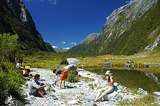
The Milford Track is a hiking route in New Zealand, located amidst mountains and temperate rain forest in Fiordland National Park in the southwest of the South Island. The 53.5 km (33.2 mi) hike starts at Glade Wharf at the head of Lake Te Anau and finishes in Milford Sound at Sandfly Point, traversing rainforests, wetlands, and an alpine pass.

The Waiau River is the largest river in the Southland region of New Zealand. 'Waiau' translates to 'River of Swirling Currents'. It is the outflow of Lake Te Anau, flowing from it into Lake Manapouri 10 kilometres (6 mi) to the south, and from there flows south for 70 kilometres (43 mi) before reaching the Foveaux Strait 8 kilometres (5 mi) south of Tuatapere. It also takes water from Lake Monowai.

The Kepler Track is a 60 km (37 mi) circular hiking track which travels through the landscape of the South Island of New Zealand and is situated near the town of Te Anau. The track passes through many landscapes of the Fiordland National Park such as rocky mountain ridges, tall mossy forests, lake shores, deep gorges, rare wetlands and rivers. Like the mountains it traverses, the track is named after Johannes Kepler. The track is one of the New Zealand Great Walks and is administered by the Department of Conservation (DOC).

The Kepler Challenge Mountain Run is the premier mountain running event in New Zealand and follows the 60 km Kepler Track through the Fiordland National Park. It has been held annually since 1988, and draws competitors from throughout New Zealand and around the world. Around 450 runners enter the event with nearly all completing the demanding course.

State Highway 94 is a New Zealand state highway connecting the large Southland town of Gore with one of New Zealand's most popular destinations, Milford Sound. It also passes the significant townships of Lumsden and Te Anau as well going through the Homer Tunnel. The road also goes through Fiordland and crosses the Main Divide of the Southern Alps.

Southland is New Zealand's southernmost region. It consists of the southwestern portion of the South Island and includes Stewart Island. Southland is bordered by the culturally similar Otago Region to the north and east, and the West Coast Region in the extreme northwest. The region covers over 3.1 million hectares and spans 3,613 km of coastline. As of June 2023, Southland has a population of 103,900, making it the eleventh-most-populous New Zealand region, and the second-most sparsely populated. Approximately half of the region's population lives in Invercargill, Southland's only city.
Leslie Hutchins was a New Zealand tourism operator and conservationist. Together with his wife, he bought a tourism company in 1954 that is today RealNZ; it still remains mostly in family ownership. Hutchins was one of the founding members of the Save Manapouri campaign and became one of the initial six Guardians of Lake Manapouri.

RealNZ is a New Zealand tourism company based in Queenstown. The company offers a range of travel, cruises and excursions in Queenstown, Milford Sound / Piopiotahi, Te Anau, Fiordland and Stewart Island / Rakiura. It also operates two skifields Cardrona Alpine Resort, and Treble Cone. The company is the successor of a series of acquisitions in the South Island tourist sector over more than 60 years. The brand RealNZ was launched in October 2021 to bring together multiple brands and businesses including Real Journeys that were previously part of the Wayfare Group, although some of the businesses have retained individual branding.

Taumoana Marine Reserve is a marine reserve covering an area of 464 hectares in Fiordland on New Zealand's South Island. It was established in 2005 and is administered by the Department of Conservation. It is located next to the Five Fingers Peninsula, at the entrance to Tamatea / Dusky Sound.

Te Tapuwae o Hua Marine Reserve is a marine reserve covering an area of 3,672 hectares in Te Awaroa / Long Sound in Fiordland on New Zealand's South Island. It was established in 2005 and is administered by the Department of Conservation.

Taipari Roa Marine Reserve is a marine reserve covering an area of 613 hectares around Elizabeth Island, in the inner Doubtful Sound / Patea of Fiordland on New Zealand's South Island. It was established in 2005 and is administered by the Department of Conservation.

Te Awaatu Channel Marine Reserve is a marine reserve covering an area of 93 hectares in Fiordland on New Zealand's South Island. It was established in 1993 and is administered by the Department of Conservation.
