Related Research Articles
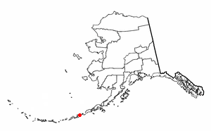
Aleutians West Census Area is a census area located in the U.S. state of Alaska. As of the 2020 census, the population was 5,232, down from 5,561 in 2010.

Nikolski is a census-designated place (CDP) on Umnak Island in Aleutians West Census Area, Alaska, United States. The population was 39 at the 2020 census, up from 18 in 2010. Nikolski is on Nikolski Bay, off the southwest end of the island. It is 116 air miles west of Unalaska, and 900 air miles from Anchorage. Residents are known as Unangan, and Aleut is spoken in most of the remaining homes.
The Fox Islands are a group of islands in the eastern Aleutian Islands of the U.S. state of Alaska. The Fox Islands are the closest to mainland North America in the Aleutian chain, and just east of Samalga Pass and the Islands of Four Mountains group.
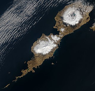
Umnak is one of the Fox Islands of the Aleutian Islands. With 686.01 square miles (1,776.76 km2) of land area, it is the third largest island in the Aleutian archipelago and the 19th largest island in the United States. The island is home to a large volcanic caldera on Mount Okmok and the only field of geysers in Alaska. It is separated from Unalaska Island by Umnak Pass. In 2000, Umnak was permanently inhabited by only 39 people and by 2010, around 18, placing the settlement of Nikolski in difficulty and its school was closed.
Amaknak Island or Umaknak Island is the most populated island in the Aleutian Islands, an archipelago which is part of the U.S. state of Alaska.

MVSelendang Ayu, IMO number: 9145528, was a Malaysian-registered Panamax bulk cargo ship chartered by the IMC Group. It ran aground off Unalaska Island in western Alaska's Aleutian Islands on 8 December 2004 after its engine failed. Six crew members died when a rescue helicopter was engulfed by a breaking wave; the ship broke in two, resulting in a large oil spill.

The Alaska Maritime National Wildlife Refuge is a United States National Wildlife Refuge comprising 2,400 islands, headlands, rocks, islets, spires and reefs in Alaska, with a total area of 4.9 million acres (20,000 km2), of which 2.64 million acres (10,700 km2) is wilderness. The refuge stretches from Cape Lisburne on the Chukchi Sea to the tip of the Aleutian Islands in the west and Forrester Island in the southern Alaska Panhandle region in the east. The refuge has diverse landforms and terrains, including tundra, rainforest, cliffs, volcanoes, beaches, lakes, and streams.

Bogoslof Island or Agasagook Island is the summit of a submarine stratovolcano at the south edge of the Bering Sea, 35 miles (56 km) northwest of Unalaska Island of the Aleutian Islands chain. It has a land area of 319.3 acres (1.292 km2) and is uninhabited. It is 1,040 meters (3,410 ft) long and 1,512 m (4,961 ft) wide, with a peak elevation of 490 feet (150 m). The stratovolcano rises about 6,000 ft (1,800 m) from the seabed, but the summit is the only part that projects above sea level. The island is believed to be relatively new, with the volcano being entirely below sea level before 1796, and most of the presently 300-acre island being formed by eruptions since 1900.
Otter Island is a small island located 6 miles (9.7 km) southwest of Saint Paul Island, Alaska, in the Bering Sea. It is a member of the Pribilof Islands. Its land area is 165.21 acres (0.6686 km2) and there is no resident population. The highest point on the island is 935 feet (285 m) above sea level. The island is closed to hunting.

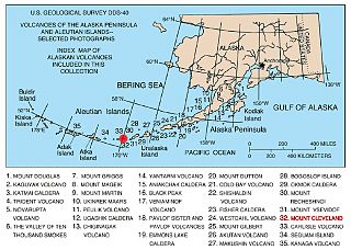
The Alaska Volcano Observatory (AVO) is a joint program of the United States Geological Survey (USGS), the Geophysical Institute of the University of Alaska Fairbanks (UAFGI), and the State of Alaska Division of Geological and Geophysical Surveys (ADGGS). AVO was formed in 1988, and uses federal, state, and university resources to monitor and study Alaska's volcanology, hazardous volcanoes, to predict and record eruptive activity, and to mitigate volcanic hazards to life and property. The Observatory website allows users to monitor active volcanoes, with seismographs and webcameras that update regularly. AVO now monitors more than 20 volcanoes in Cook Inlet, which is close to Alaskan population centers, and the Aleutian Arc due to the hazard that plumes of ash pose to aviation.
Unalga Island is one of the Fox Islands subgroup of the Aleutian Islands of southwestern Alaska, United States. It lies just northeast of Unalaska Island and across Akutan Pass from Akutan Island to its northeast. It is the westernmost island in the Aleutians East Borough. Unalga Island has a land area of 11.004 square miles and is unpopulated. The island is 6.7 kilometres (4.2 mi) long and 8.2 kilometres (5.1 mi) wide.
Egg Island is a small island in the Fox Islands subgroup of the Aleutian Islands in the U.S. state of Alaska. It lies off the eastern end of Unalaska Island and just off the northeastern tip of Sedanka Island. It is the easternmost island in the Aleutians West Census Area of Alaska. The island has a land area of 311.12 acres (1.2591 km2) and is uninhabited.

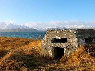
Cape Field at Fort Glenn was a military site significant for its role in World War II. It consists of Fort Glenn, an airfield of the United States Army Air Corps later renamed Cape Air Force Base, and the adjacent Naval Air Facility Otter Point, both located on Umnak Island in the Aleutian Islands of southwestern Alaska. The site was listed on the National Register of Historic Places and declared a National Historic Landmark in 1987.

Unalaska is a volcanic island in the Fox Islands group of the Aleutian Islands in the US state of Alaska located at 53°38′N167°00′W. The island has a land area of 1,051 square miles (2,720 km2). It measures 79.4 mi (127.8 km) long and 34.7 mi (55.8 km) wide. The city of Unalaska, Alaska, covers part of the island and all of neighboring Amaknak Island where the Port of Dutch Harbor is located. The population of the island excluding Amaknak as of the 2000 census was 1,759 residents.
Anangula Island is a small island in the Fox Islands group of the Aleutian Islands of southwestern Alaska. The 1.4-mile (2.3 km)-long island is separated from Umnak Island by a channel about 0.93 miles (1.50 km) wide and consists of a mostly barren tundra landscape of volcanic ash.

Amak Volcano is a basaltic andesite stratovolcano in the Aleutian Islands of Alaska, United States, 618 miles (995 km) from Anchorage. It is located on the eponymous island, 31 miles (50 km) from Frosty Volcano and near the edge of the Alaskan Peninsula's western flank. Only boats are allowed to access the island with a certain permit.
The Aleutian Arc is a large volcanic arc of islands extending from the Southwest tip of the U.S. state of Alaska to the Kamchatka Peninsula of the Russian Federation.

The Aleutian Islands —also called the Aleut Islands, Aleutic Islands, or, before 1867, the Catherine Archipelago—are a chain of 14 main, larger volcanic islands and 55 smaller ones. Most of the Aleutian Islands belong to the U.S. state of Alaska, with the archipelago encompassing the Aleutians West Census Area and the Aleutians East Borough. The Commander Islands, located further to the west, belong to the Russian federal subject of Kamchatka Krai, of the Russian Far East. The islands form part of the Aleutian Arc of the Northern Pacific Ocean, and occupy a land area of 6,821 sq mi (17,666 km2) that extends westward roughly 1,200 mi (1,900 km) from the Alaskan Peninsula mainland, in the direction of the Kamchatka Peninsula; the archipelago acts as a border between the Bering Sea to the north and the Pacific Ocean to the south. Crossing longitude 180°, at which point east and west longitude end, the archipelago contains both the westernmost and easternmost parts of the United States, by longitude. The westernmost U.S. island, in real terms, however, is Attu Island, west of which runs the International Date Line.
Cape Air Force Base also known as Fort Glenn Army Air Base, is a site significant for its role in World War II fighting, operating alongside Naval Air Facility Otter Point.
Cold Bay Air Force Station is a closed United States Air Force General Surveillance Radar station. It is located 625 miles (1,006 km) southwest of Anchorage, Alaska.
References
- ↑ Voice, Senior. "Alaska's island of mystery". Senior Voice. Retrieved 2024-11-11.
- ↑ "Life returns fast to lonely island". www.uaf.edu. Retrieved 2024-11-11.
| | This article about a location in the Aleutians West Census Area, Alaska is a stub. You can help Wikipedia by expanding it. |