Related Research Articles
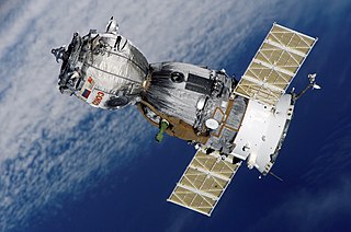
In the context of spaceflight, a satellite is an object that has been intentionally placed into orbit. These objects are called artificial satellites to distinguish them from natural satellites such as Earth's Moon.
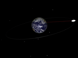
A geosynchronous orbit is an Earth-centered orbit with an orbital period that matches Earth's rotation on its axis, 23 hours, 56 minutes, and 4 seconds. The synchronization of rotation and orbital period means that, for an observer on Earth's surface, an object in geosynchronous orbit returns to exactly the same position in the sky after a period of one sidereal day. Over the course of a day, the object's position in the sky may remain still or trace out a path, typically in a figure-8 form, whose precise characteristics depend on the orbit's inclination and eccentricity. A circular geosynchronous orbit has a constant altitude of 35,786 km (22,236 mi), and all geosynchronous orbits share that semi-major axis.

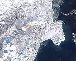
Satellite temperature measurements are inferences of the temperature of the atmosphere at various altitudes as well as sea and land surface temperatures obtained from radiometric measurements by satellites. These measurements can be used to locate weather fronts, monitor the El Niño-Southern Oscillation, determine the strength of tropical cyclones, study urban heat islands and monitor the global climate. Wildfires, volcanos, and industrial hot spots can also be found via thermal imaging from weather satellites.

A wildfire, wildland fire or rural fire is an uncontrolled fire in an area of combustible vegetation occurring in rural areas. Depending on the type of vegetation present, a wildfire can also be classified more specifically as a brush fire, bushfire, desert fire, forest fire, grass fire, hill fire, peat fire, prairie fire, vegetation fire, or veld fire. Many organizations consider wildfire to mean an unplanned and unwanted fire, while wildland-fire is a broader term that includes prescribed fire as well as wildland fire use.

An unmanned aerial vehicle (UAV) is an aircraft without a human pilot on board and a type of unmanned vehicle. UAVs are a component of an unmanned aircraft system (UAS); which include a UAV, a ground-based controller, and a system of communications between the two. The flight of UAVs may operate with various degrees of autonomy: either under remote control by a human operator, autonomously by onboard computers or piloted by an autonomous robot.

The Landsat program is the longest-running enterprise for acquisition of satellite imagery of Earth. It is a joint NASA/USGS program. On July 23, 1972 the Earth Resources Technology Satellite was launched. This was eventually renamed to Landsat. The most recent, Landsat 8, was launched on February 11, 2013. The instruments on the Landsat satellites have acquired millions of images. The images, archived in the United States and at Landsat receiving stations around the world, are a unique resource for global change research and applications in agriculture, cartography, geology, forestry, regional planning, surveillance and education, and can be viewed through the U.S. Geological Survey (USGS) 'EarthExplorer' website. Landsat 7 data has eight spectral bands with spatial resolutions ranging from 15 to 60 meters ; the temporal resolution is 16 days. Landsat images are usually divided into scenes for easy downloading. Each Landsat scene is about 115 miles long and 115 miles wide.
The Moderate Resolution Imaging Spectroradiometer (MODIS) is a payload imaging sensor built by Santa Barbara Remote Sensing that was launched into Earth orbit by NASA in 1999 on board the Terra satellite, and in 2002 on board the Aqua satellite. The instruments capture data in 36 spectral bands ranging in wavelength from 0.4 μm to 14.4 μm and at varying spatial resolutions. Together the instruments image the entire Earth every 1 to 2 days. They are designed to provide measurements in large-scale global dynamics including changes in Earth's cloud cover, radiation budget and processes occurring in the oceans, on land, and in the lower atmosphere. MODIS utilizes four on-board calibrators in addition to the space view in order to provide in-flight calibration: solar diffuser (SD), solar diffuser stability monitor (SDSM), spectral radiometric calibration assembly (SRCA), and a v-groove black body. MODIS has used the marine optical buoy for vicarious calibration. MODIS is succeeded by the VIIRS instrument on board the Suomi NPP satellite launched in 2011 and future Joint Polar Satellite System (JPSS) satellites.
Orbital Sciences Corporation was an American company specializing in the design, manufacture and launch of small- and medium- class space and rocket systems for commercial, military and other government customers. In 2014 Orbital merged with Alliant Techsystems to create a new company called Orbital ATK, Inc., which in turn was purchased by Northrop Grumman in 2018. The remnants of the former Orbital Sciences Corporation today are a subsidiary of Northrop Grumman and is known as Northrop Grumman Innovation Systems.

Geosynchronous Satellite Launch Vehicle (GSLV) is an expendable launch system operated by the Indian Space Research Organisation (ISRO). GSLV was used in thirteen launches from 2001 to 2018, with more launches planned. Even though GSLV Mark III shares the name, it is an entirely different launch vehicle.
The Indian Space Research Organisation is the space agency of the Government of India and has its headquarters in the city of Bangalore. Its vision is to "harness space technology for national development while pursuing space science research & planetary exploration". The Indian National Committee for Space Research (INCOSPAR) was established by Jawaharlal Nehru under the Department of Atomic Energy (DAE) in 1962, with the urging of scientist Vikram Sarabhai recognising the need in space research. INCOSPAR grew and became ISRO in 1969, also under the DAE. In 1972, the Government of India had set up a Space Commission and the Department of Space (DOS), bringing ISRO under the DOS. The establishment of ISRO thus institutionalised space research activities in India. It is managed by the DOS, which reports to the Prime Minister of India.
Fuego is the Spanish word for "fire". It may also refer to:
PAS-22, previously known as AsiaSat 3 and then HGS-1, was a geosynchronous communications satellite, which was salvaged from an unusable geosynchronous transfer orbit by means of the Moon's gravity.
The Department of Space (DoS) is an Indian government department responsible for administration of the Indian space program. It manages several agencies and institutes related to space exploration and space technologies. The Indian space program under the DoS aims to promote the development and application of space science and technology for the socio-economic benefit of the country. It includes two major satellite systems, INSAT for communication, television broadcasting and meteorological services, and Indian Remote Sensing Satellites (IRS) system for resources monitoring and management. It has also developed two satellite launch vehicles Polar Satellite Launch Vehicle (PSLV) and Geosynchronous Satellite Launch Vehicle (GSLV) to place IRS and INSAT class satellites in orbit.
Upravlyaemy Sputnik Kontinentalny or US-K is a series of Russian, previously Soviet, satellites used to detect missile launches as part of the Oko system. It consists of a constellation of satellites, usually in molniya orbits, designated under the Kosmos system. The satellites are built by the company NPO Lavochkin and are launched on Molniya-M rockets. Oko can be directly translated as the Russian word for eye. As of June 2014, only two of the eight satellites in orbit were still functional, rendering the system inoperable.

Atmospheric satellite or pseudo-satellite is a marketing term for an aircraft that operates in the atmosphere at high altitudes for extended periods of time, in order to provide services conventionally provided by an artificial satellite orbiting in space.
Technosignature or technomarker is any measurable property or effect that provides scientific evidence of past or present technology. Technosignatures are analogous to the biosignatures that signal the presence of life, whether or not intelligent. Some authors prefer to exclude radio transmissions from the definition, but such restrictive usage is not widespread. Jill Tarter has proposed that the search for extraterrestrial intelligence (SETI) be renamed "the search for technosignatures". Various types of technosignatures, such as radiation leakage from megascale astroengineering installations such as Dyson spheres, the light from an extraterrestrial ecumenopolis, or Shkadov thrusters with the power to alter the orbits of stars around the Galactic Center, may be detectable with hypertelescopes. Some examples of technosignatures are described in Paul Davies's 2010 book The Eerie Silence, although the terms "technosignature" and "technomarker" do not appear in the book.
Deimos and Phobos Interior Explorer (DePhine) is a European mission concept to use a dedicated orbiter to explore the two Moons of Mars: Phobos and Deimos. The mission concept was proposed in 2016 to the European Space Agency's Cosmic Vision programme for launch in 2030, but it was not chosen as a finalist for the M5 mission class.

Drones, also known as Unmanned Aerial Systems/Vehicles (UAS/UAV), or Remotely Piloted Aircraft, are used in wildfire surveillance and suppression. They help in the detection, containment, and extinguishing of fires. They are also used for locating a hot spot, firebreak breaches, and then to deliver water to the affected site. In terms of maneuverability, these are superior to a helicopter or other forms of manned aircraft. They help firefighters determine where a fire will spread through tracking and mapping fire patterns. These empower scientists and incident personnel to make informed decisions. These devices can fly when and where manned aircraft are unable to fly. They are associated with low cost and are flexible devices that offer a high spatiotemporal resolution.
References
- ↑ "Fighting Forest Fires Before They Get Big—With Drones". WIRED . 9 June 2015. Retrieved 27 December 2015.
- ↑ Staff, Tianyi Dong | (6 July 2015). "Berkeley researchers develop satellite, drones system for wildfire detection". The Daily Californian . Retrieved 27 December 2015.
- ↑ Pennypacker, Carlton R.; Jakubowski, Marek K.; Kelly, Maggi; Lampton, Michael; Schmidt, Christopher; Stephens, Scott; Tripp, Robert (17 October 2013). "FUEGO – Fire Urgency Estimator in Geosynchronous Orbit – A Proposed Early-Warning Fire Detection System". Remote Sensing. 5 (10): 5173–5192. Bibcode:2013RemS....5.5173P. doi: 10.3390/rs5105173 .