The Republic of Texas, or simply Texas, was a breakaway state in North America. It existed for just under 10 years, from March 2, 1836 to February 19, 1846. It shared borders with Mexico, the Republic of the Rio Grande, and the United States of America.

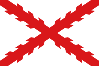
Santa Fe de Nuevo México was a province of the Spanish Empire and New Spain, and later a territory of independent Mexico. The first capital was San Juan de los Caballeros from 1598 until 1610, and from 1610 onward the capital was La Villa Real de la Santa Fe de San Francisco de Asís.

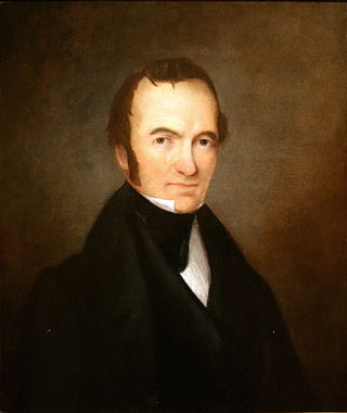
Stephen Fuller Austin was an American-born empresario. Known as the "Father of Texas" and the founder of Anglo Texas, he led the second and, ultimately, the successful colonization of the region by bringing 300 families and their slaves from the United States to the Tejas region of Mexico in 1825.

The Territory of Kansas was an organized incorporated territory of the United States that existed from May 30, 1854, until January 29, 1861, when the eastern portion of the territory was admitted to the Union as the free state of Kansas.

The Mexican Cession is the region in the modern-day western United States that Mexico previously controlled, then ceded to the United States in the Treaty of Guadalupe Hidalgo in 1848 after the Mexican–American War. This region had not been part of the areas east of the Rio Grande that had been claimed by the Republic of Texas, which had been claiming independence since its Texas Revolution of 1836 and subsequent brief war for independence, followed afterwards a decade later by the American annexation and admitted statehood in 1845. It had not specified the southern and western boundary of the new state of Texas with New Mexico consisting of roughly 529,000 square miles (1,370,000 km2), not including any Texas lands, the Mexican Cession was the third-largest acquisition of territory in U.S. history, surpassed only by the 827,000-square-mile (2,140,000 km2) Louisiana Purchase of 1803 and the later 586,000-square-mile (1,520,000 km2) Alaska Purchase from Russia in 1867.

The District of Louisiana, or Louisiana District, was an official and temporary United States government designation for the portion of the Louisiana Purchase that had not been organized into the Territory of Orleans or "Orleans Territory". The district officially existed from March 10, 1804, until July 4, 1805, when it was organized as the Louisiana Territory.

The Territory of Missouri was an organized incorporated territory of the United States that existed from June 4, 1812, until August 10, 1821. In 1819, the Territory of Arkansas was created from a portion of its southern area. In 1821, a southeastern portion of the territory was admitted to the Union as the State of Missouri, and the rest became unorganized territory for several years.

In the United States before 1865, a slave state was a state in which slavery and the internal or domestic slave trade were legal, while a free state was one in which they were prohibited. Between 1812 and 1850, it was considered by the slave states to be politically imperative that the number of free states not exceed the number of slave states, so new states were admitted in slave–free pairs. There were, nonetheless, some slaves in most free states up to the 1840 census, and the Fugitive Slave Clause of the U.S. Constitution, as implemented by the Fugitive Slave Act of 1793 and the Fugitive Slave Act of 1850, provided that a slave did not become free by entering a free state and must be returned to their owner. Enforcement of these laws became one of the controversies which arose between slave and free states.

The territory of the United States and its overseas possessions has evolved over time, from the colonial era to the present day. It includes formally organized territories, proposed and failed states, unrecognized breakaway states, international and interstate purchases, cessions, and land grants, and historical military departments and administrative districts. The last section lists informal regions from American vernacular geography known by popular nicknames and linked by geographical, cultural, or economic similarities, some of which are still in use today.

The Santa Fe Trail was a 19th-century route through central North America that connected Franklin, Missouri, with Santa Fe, New Mexico. Pioneered in 1821 by William Becknell, who departed from the Boonslick region along the Missouri River, the trail served as a vital commercial highway until 1880, when the railroad arrived in Santa Fe. Santa Fe was near the end of El Camino Real de Tierra Adentro which carried trade from Mexico City. The trail was later incorporated into parts of the National Old Trails Road and U.S. Route 66.

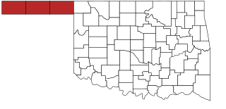
The Oklahoma Panhandle is a salient in the extreme northwestern region of the U.S. state of Oklahoma. It consists of, from west to east, Cimarron County, Texas County and Beaver County. As with other salients in the United States, its name comes from the similarity of its shape to the handle of a pan. Its largest city is Guymon in Texas County. Black Mesa State Park, located in Cimarron County, is the highest point in the state. Other points of interest include Beaver Dunes Park, Optima Lake, and the Optima National Wildlife Refuge. Oklahoma Panhandle State University is ten miles away from Guymon.
William Becknell was an American soldier, politician, and freight operator who is credited by Americans with opening the Santa Fe Trail in 1821. He found a trail for part of the route that was wide enough for wagon trains and draft teams, making it easier for trader and emigrants along this route. The Santa Fe Trail became an early major transportation route through central North America that connected Franklin, Missouri with Santa Fe, New Mexico, serving both trading and emigrant parties. It served as a vital commercial highway from the 1820s until 1880, when the railroad was introduced to Santa Fe. Becknell made use of long-established trails made by Native Americans, and Spanish and French colonial explorers and traders for centuries before his trip.

The parallel 36°30′ north is a circle of latitude that is 36 and one-half degrees north of the equator of the Earth. This parallel of latitude is particularly significant in the history of the United States as the line of the Missouri Compromise, which was used to divide the prospective slave and free states west of the Mississippi River, with the exception of Missouri, which is mostly north of this parallel. The line continues to hold cultural, economic and political significance to this day; the Kinder Institute for Urban Research defines the Sun Belt as being south of 36°30′N latitude.

Louisiana, or the Province of Louisiana, was a province of New Spain from 1762 to 1801 primarily located in the center of North America encompassing the western basin of the Mississippi River plus New Orleans. The area had originally been claimed and controlled by France, which had named it La Louisiane in honor of King Louis XIV in 1682. Spain secretly acquired the territory from France near the end of the Seven Years' War by the terms of the Treaty of Fontainebleau (1762). The actual transfer of authority was a slow process, and after Spain finally attempted to fully replace French authorities in New Orleans in 1767, French residents staged an uprising which the new Spanish colonial governor did not suppress until 1769. Spain also took possession of the trading post of St. Louis and all of Upper Louisiana in the late 1760s, though there was little Spanish presence in the wide expanses of what they called the "Illinois Country".
The timeline of Kansas details past events that happened in what is present day Kansas. Located on the eastern edge of the Great Plains, the U.S. state of Kansas was the home of sedentary agrarian and hunter-gatherer Native American societies, many of whom hunted American bison. The region first appears in western history in the 16th century at the time of the Spanish conquest of the Aztec Empire, when Spanish conquistadors explored the unknown land now known as Kansas. It was later explored by French fur trappers who traded with the Native Americans. It became part of the United States in the Louisiana Purchase of 1803. In the 19th century, the first American explorers designated the area as the "Great American Desert."

The 1763 Treaty of Paris ended the major war known by Americans as the French and Indian War and by Canadians as the Seven Years' War / Guerre de Sept Ans, or by French-Canadians, La Guerre de la Conquête. It was signed by Great Britain, France and Spain, with Portugal in agreement. Preferring to keep Guadeloupe, France gave up Canada and all of its claims to territory east of the Mississippi River to Britain. With France out of North America this dramatically changed the European political scene on the continent.
Silas Bent Jr. was an American land surveyor, attorney, and jurist who served as a Judge of the Missouri Supreme Court from 1817 to 1821. His son, Charles Bent, was a fur trader and appointed as the first territorial governor of New Mexico during the United States invasion of Mexico in the Mexican-American War. Three of his other sons William, George, and Robert had been in business with Charles and built Bent's Old Fort and other outposts of trade in the American Southwest.
Facundo Melgares was a Spanish military officer who served as both the last Spanish Governor of New Mexico and the first Mexican Governor of New Mexico. Melgares was, like most of the officials of the Spanish crown in his time, a member of the Spanish upper class. He is described as a "portly man of military demeanour" and as "a gentleman and gallant soldier".


