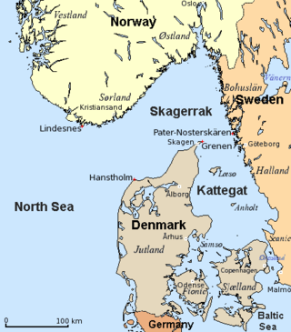
The Kattegat is a 30,000 km2 (12,000 sq mi) sea area bounded by the peninsula of Jutland in the west, the Danish straits islands of Denmark and the Baltic Sea to the south and the Swedish provinces of Bohuslän, Västergötland, Halland and Scania in Sweden in the east. The Baltic Sea drains into the Kattegat through the Danish straits. The sea area is a continuation of the Skagerrak and may be seen as a bay of the North Sea and North Atlantic Ocean, though this is not the case in traditional Scandinavian usage.

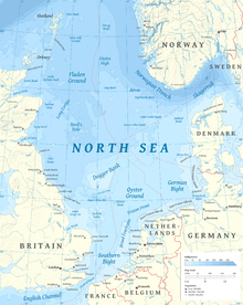
The North Sea lies between Great Britain, Denmark, Norway, Germany, the Netherlands, Belgium and France. An epeiric sea on the European continental shelf, it connects to the Atlantic Ocean through the English Channel in the south and the Norwegian Sea in the north. It is more than 970 kilometres (600 mi) long and 580 kilometres (360 mi) wide, covering 570,000 square kilometres (220,000 sq mi).

The Wash is a shallow natural rectangular bay and multiple estuary on the east coast of England in the United Kingdom. It is an inlet of the North Sea and is the largest multiple estuary system in the UK, as well as being the largest natural bay in England and is the outflow for the rivers Witham, Welland, Nene and the Great Ouse. It is also one of the most important places of conservation in Europe, with several nature reserves located within this area.

The Shipping Forecast is a BBC Radio broadcast of weather reports and forecasts for the seas around the British Isles. It is produced by the Met Office and broadcast by BBC Radio 4 on behalf of the Maritime and Coastguard Agency. The forecast dates back over 150 years. There are currently two or three broadcasts per day, at 00:48, 05:20, and 17:54 UK local time.
The Skagerrak is a strait running between the Jutland peninsula of Denmark, the east coast of Norway and the west coast of Sweden, connecting the North Sea and the Kattegat sea.

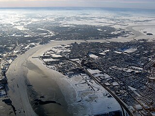
IJmuiden is a port city in the Dutch province of North Holland. It is the main town in the municipality of Velsen which lies mainly to the south-east. Including its large sea locks, it straddles the mouth of the North Sea Canal to Amsterdam. To the south it abuts a large reserve of plant-covered dunes, the Zuid-Kennemerland National Park. The city is on the south bank; the north bank is otherwise a steel plant and Velsen-Noord.

The Little Belt is a strait between the island of Funen and the Jutland Peninsula in Denmark. It is one of the three Danish Straits that drain and connect the Baltic Sea to the Kattegat strait, which drains west to the North Sea and Atlantic Ocean.

The Frisian Islands, also known as the Wadden Islands or the Wadden Sea Islands, form an archipelago at the eastern edge of the North Sea in northwestern Europe, stretching from the northwest of the Netherlands through Germany to the west of Denmark. The islands shield the mudflat region of the Wadden Sea from the North Sea.

The Second Happy Time was a phase in the Battle of the Atlantic during which Axis submarines attacked merchant shipping and Allied naval vessels along the east coast of North America. The First Happy Time was in 1940–1941 in the North Atlantic and North Sea. Adolf Hitler and Benito Mussolini declared war on the United States on 11 December 1941, and as a result their navies could begin the Second Happy Time.
The Limfjord is a shallow part of the sea, located in Denmark where it has been regarded as an inlet ever since Viking times. However, it now has entries both from the North Sea and Kattegat, and hence separates the North Jutlandic Island from the rest of the Jutland Peninsula. The Limfjord extends from Thyborøn Channel on the North Sea to Hals on the Kattegat. It is approximately 180 kilometres long and of an irregular shape with numerous bays, narrowings, and islands, most notably Mors, and the smaller ones Fur, Venø, Jegindø, Egholm and Livø. It is deepest at Hvalpsund.

The German Bight is the southeastern bight of the North Sea bounded by the Netherlands and Germany to the south, and Denmark and Germany to the east. To the north and west it is limited by the Dogger Bank. The Bight contains the Frisian and Danish Islands. The Wadden Sea is approximately ten to twelve kilometres wide at the location of the German Bight. The Frisian islands and the nearby coastal areas are collectively known as Frisia. The southern portion of the bight is also known as the Heligoland Bight. Between 1949 and 1956 the BBC Sea Area Forecast used "Heligoland" as the designation for the area now referred to as German Bight.

Dogger Bank is a large sandbank in a shallow area of the North Sea about 100 kilometres (62 mi) off the east coast of England.
Long Forties is a zone of the northern North Sea that is fairly consistently forty fathoms deep.

The Outer Banks are a 200 mi (320 km) string of barrier islands and spits off the coast of North Carolina and southeastern Virginia, on the east coast of the United States. They line most of the North Carolina coastline, separating Currituck Sound, Albemarle Sound, and Pamlico Sound from the Atlantic Ocean. A major tourist destination, the Outer Banks are known for their wide expanse of open beachfront and the Cape Hatteras National Seashore. The seashore and surrounding ecosystem are important biodiversity zones, including beach grasses and shrubland that help maintain the form of the land.
Kangersuatsiaq, formerly Prøven, is an island settlement in the Avannaata municipality in northwestern Greenland. It had 130 inhabitants in 2020.

Selsey Bill is a headland into the English Channel on the south coast of England in the county of West Sussex.
The Sole Bank is a sand bank in the Atlantic Ocean, south-west of Cornwall.

Iroise or the Iroise Sea is the part of the Atlantic Ocean which stretches from the Ile de Sein to Ushant off the coast of Brittany in north-western France. It is contained within the Celtic Sea, bordering the remainder of the Celtic Sea to the north and west, and the Bay of Biscay to the south. It is one of the most dangerous seas in Europe for sea-going vessels. In winter, there are often violent storms with huge waves. It is also one of the richest areas for marine life and was designated as one of UNESCO's biosphere reserves in 1988 and as France's first marine park in October 2007.
The geography of the North Sea studies coastal and submarine features as well as the people who live on its coasts. It is bounded by the east coasts of England and Scotland to the west and the northern and central European mainland to the east and south, including Norway, Denmark, Germany, the Netherlands, Belgium, and France. In the south-west, beyond the Straits of Dover, the North Sea becomes the English Channel. In the east, it connects to the Baltic Sea via the Skagerrak and Kattegat, narrow straits that separate Denmark from Norway and Sweden respectively. In the north, it opens in a widening funnel shape to the Norwegian Sea, which lies in the very north-eastern part of the Atlantic.