External links
| | This article about a location in Western Australia is a stub. You can help Wikipedia by expanding it. |
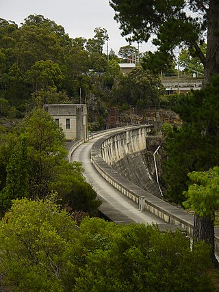
The Fitzroy River Barrage is a dam type structure built as part of the Camballin Irrigation Scheme in Western Australia. [1]
It was a series of collapsible shutters which were designed to collapse when the river level was approximately twelve inches over the shutters. The structure was intended to divert the water in the Fitzroy River to be stored in the Seventeen Mile Dam, by flowing up Uralla Creek, unnaturally in the opposite direction. [2] [3]
The barrage was built by the Public Works Department of Western Australia and was designed to hold 4.58 x 10⁶ cubic metres of water. [4] [5]
A small village was erected at the barrage site during the construction phase. Presently there is still the superstructure remaining along with the stilted shed which was used as a machinery shed. The Department of Water currently still maintains a small shed on the site for its stream gauging equipment.
{{citation}}: CS1 maint: multiple names: authors list (link)| | This article about a location in Western Australia is a stub. You can help Wikipedia by expanding it. |

A dam is a barrier that stops or restricts the flow of surface water or underground streams. Reservoirs created by dams not only suppress floods but also provide water for activities such as irrigation, human consumption, industrial use, aquaculture, and navigability. Hydropower is often used in conjunction with dams to generate electricity. A dam can also be used to collect or store water which can be evenly distributed between locations. Dams generally serve the primary purpose of retaining water, while other structures such as floodgates or levees are used to manage or prevent water flow into specific land regions.

The St. Francis Dam was a concrete gravity dam located in San Francisquito Canyon in northern Los Angeles County, California that was built between 1924 and 1926 to serve the city of Los Angeles's growing water needs. It failed catastrophically in 1928 due to a defective soil foundation and design flaws, unleashing a flood that claimed the lives of at least 431 people. The collapse of the dam is considered to have been one of the worst American civil engineering disasters of the 20th century, and remains the 3rd-greatest loss of life in California's history, exceeded only by the 1906 San Francisco earthquake and fire and the Great Flood of 1862.

Lake Parramatta is a heritage-listed man-made reservoir and a recreational area located in North Parramatta, City of Parramatta, in the Western Sydney region of New South Wales, Australia. The masonry arch-walled dam across Hunts Creek was completed in 1856 to supply water for domestic purposes; and was operational until 1909. The dam has since been decommissioned and the lake and the surrounding nature reserve are a popular recreational area.

The Fitzroy River is located in the West Kimberley region of Western Australia. It has 20 tributaries and its catchment occupies an area of 93,829 square kilometres (36,228 sq mi), within the Canning Basin and the Timor Sea drainage division.

The Cataract Dam is a heritage-listed dam in Cataract, New South Wales, Australia, provides water to the Macarthur and Illawarra regions, the Wollondilly Shire, and metropolitan Sydney. It is one of four dams and weirs in the catchment of the Upper Nepean Scheme. Completed in 1907 under the supervision of Ernest Macartney de Burgh, the dam is currently owned by Water NSW, an agency of the Government of New South Wales. The dam was listed on the NSW State Heritage Register on 18 November 1999.

The Cordeaux Dam is a heritage-listed dam in Cordeaux, New South Wales, Australia. It provides water to the Macarthur and Illawarra regions, the Wollondilly Shire, and metropolitan Sydney. It is one of four dams and weirs in the catchment of the Upper Nepean Scheme. Completed in 1926 under the supervision of Ernest Macartney de Burgh, the dam is owned by Water NSW, an agency of the Government of New South Wales. It was listed on the New South Wales State Heritage Register on 18 November 1999.
The Nepean Dam is a heritage-listed dam split across Avon in the Wingecarribee Shire and Bargo in the Wollondilly Shire, both in New South Wales, Australia. The reservoir created by the dam spreads across Avon, Bargo and also Yerrinbool in Wingecarribee Shire. The Nepean Dam is one of four dams and weirs in the catchment of the Upper Nepean Scheme, in New South Wales, Australia, and provides water to the Macarthur and Illawarra regions, the Wollondilly Shire, and metropolitan Sydney. Completed in 1935 under the supervision of Ernest Macartney de Burgh, the dam is currently managed by the Sydney Catchment Authority and is listed on the New South Wales State Heritage Register.

The Avon Dam is a heritage-listed dam in Avon, Wingecarribee Shire, New South Wales, Australia. It is one of four dams and weirs in the catchment of the Upper Nepean Scheme, providing water to the Macarthur and Illawarra regions, the Wollondilly Shire, and metropolitan Sydney. The arch dam across the Avon River was completed in 1927 under the supervision of Ernest Macartney de Burgh, the dam is currently managed by the Sydney Catchment Authority and is listed on the New South Wales State Heritage Register.

The Woronora Dam is a heritage-listed concrete gravity dam with an uncontrolled serpentine spillway across the Woronora River, located south of Greater Metropolitan Sydney, in the suburb of Woronora Dam, Sutherland Shire, New South Wales, Australia. The principal purpose of the dam is for potable water supply for Sydney's southern suburbs and the northern suburbs of the Illawarra region. The impounded 71,790-megalitre reservoir is also called Woronora Dam and is sometimes incorrectly called Lake Woronora. The dam was designed by G. E. Haskins, Chief Engineer and the Metropolitan Water, Sewerage and Drainage Board of NSW (MWS&DB) and built from 1927 to 1941 by the MWS&DB. The property is owned by the Sydney Catchment Authority, an agency of the Government of New South Wales. It was added to the New South Wales State Heritage Register on 18 November 1999.

The Prospect Reservoir is a heritage-listed 50,200-megalitre potable water supply and storage reservoir created by the Prospect Dam, across the Prospect Creek located in the Western Sydney suburb of Prospect, in New South Wales, Australia. The eastern bounds of the reservoir are a recreational area and the western periphery are within the bounds of Western Sydney Parklands. It was added to the New South Wales State Heritage Register on 18 November 1999.
The Public Works Department (PWD) was the State Government Agency of Western Australia, which was charged with providing and maintaining public infrastructure such as dams, water supplies, schools, hospitals, harbours and other public buildings. The department is no longer operational, having its responsibilities reassigned to other State Government Departments and corporate entities since 1985.
The Camballin Irrigation Scheme consisted of the Fitzroy River Barrage, the Seventeen Mile Dam, Company Pump, numerous irrigation channels, a seventeen kilometre levee bank, silos for grain storage which were built at the Broome Jetty and other support infrastructure located at the Camballin townsite.
The Seventeen Mile Dam was constructed as part of the Camballin Irrigation Scheme by the Public Works Department of Western Australia.
Camballin is a small town in the West Kimberley district of Western Australia. The town is located on the Camballin Station about 110 km (68 mi) south of Derby and between Derby and Fitzroy Crossing, with the homestead being situated in the town. The town was established in the 1950s by the Public Works Department of Western Australia to service the Camballin Irrigation Scheme.

The Canning Dam and reservoir are a major source of fresh water for the city of Perth, Western Australia. The dam is situated on the Darling Scarp and is an impoundment of the Canning River. It is noted for its innovative structural and hydraulic design that was considered to be at the forefront of concrete gravity dam design at the time of construction in from 1933 to its completion 1940.
Dimond Gorge is a gorge on the Fitzroy River, Western Australia, within Mornington Sanctuary.
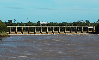
The Fitzroy River Barrage is a mid-river dam system constructed on the Fitzroy River in Rockhampton, Queensland, Australia which separates the tidal river into saltwater and freshwater sections. It was designed to dam the river, enabling a permanent water supply to be stored for the city and its surrounding communities as well as providing an agricultural water supply for registered rural users.

Aldeadávila Dam is a concrete arch-gravity dam on the Duero River in Spain, near the border with Portugal. The nearest town is Aldeadávila de la Ribera in the Province of Salamanca, about 11.3 kilometres (7.0 mi) to the east. The nearest Portuguese town is Fornos in Bragança District, about 8 kilometres (5.0 mi) to the southwest. The Portuguese side of the river around the dam site lies within the Arribes del Duero Natural Park.

A barrage is a type of low-head, diversion dam which consists of a number of large gates that can be opened or closed to control the amount of water passing through. This allows the structure to regulate and stabilize river water elevation upstream for use in irrigation and other systems. The gates are set between flanking piers which are responsible for supporting the water load of the pool created. The term barrage is borrowed from the French word "barrer" meaning "to bar".

The Bethanga Bridge is a steel truss road bridge that carries the Riverina Highway across Lake Hume, an artificial lake on the Murray River in Australia. The dual heritage-listed bridge crosses the border between the Australian states of New South Wales and Victoria, linking the Victorian towns of Bellbridge and Bethanga with the regional New South Wales city of Albury.