
Five Mile Plains in Nova Scotia
Five Mile Plains is a community in the Canadian province of Nova Scotia, located in the Municipal District of West Hants.
Five Mile Plains is a community in the Canadian province of Nova Scotia, located in the Municipal District of West Hants.

The Gulf of St. Lawrence is the outlet of the North American Great Lakes via the St. Lawrence River into the Atlantic Ocean. The gulf is a semi-enclosed sea, covering an area of about 226,000 square kilometres (87,000 sq mi) and containing about 34,500 cubic kilometres (8,300 cu mi) of water, at an average depth of 152 metres (500 ft).
Greenwood is a village located in the western part of Kings County in Nova Scotia's Annapolis Valley.

The Municipality of the District of Chester is a Nova Scotia district municipality occupying the northeastern half of Lunenburg County, Canada.
Mill Village is a Canadian rural community in the Region of Queens Municipality, Nova Scotia. It developed in relation to the lumber industry. Located inland from the Atlantic coast, Mill Village was the site of Canada's first satellite earth station constructed in the 1960s.

The Sackville River is a river in Hants County and Halifax Regional Municipality, Nova Scotia, Canada. It empties into Bedford Basin. The Little Sackville River is a tributary.

The St. Croix River is a river in Nova Scotia entirely contained in Hants and Halifax Counties. Its headwaters are Panuke Lake. The river has been exploited for water power. There were water mills in the nineteenth century and in the 1930s three hydroelectric dams were built; they still operate.
Lewis Lake, Nova Scotia could mean the following:
Flat Lake (Nova Scotia) could refer to the following lakes:
Port Medway is a community in the Canadian province of Nova Scotia, located in the Region of Queens Municipality.
The Lodge is a small community in the Canadian province of Nova Scotia, located in the Chester Municipal District on the Aspotogan Peninsula. Its only significant road is Nova Scotia Route 329, on the Lighthouse Route.
Middlefield is a community in the Canadian province of Nova Scotia, located in the Region of Queens Municipality.
Newcombville is a community in the Canadian province of Nova Scotia, located in the Lunenburg Municipal District in Lunenburg County 11 kilometers or seven miles from Bridgewater-the county service center on the shores of the LaHave River.
Blockhouse is a community in the Canadian province of Nova Scotia, located in the Lunenburg Municipal District in Lunenburg County. It was named after the blockhouses constructed by Captain Ephraim Cook to protect colonists following a raid in 1756. The final blockhouse in the community burned down in 1874.
Hebb's Cross is a community in the Canadian province of Nova Scotia, located in the Municipality of the District of Lunenburg in Lunenburg County on Highway 103 about seven miles south-southwest of Bridgewater, between Hebbville and Italy Cross.
Torbrook is a community in the Canadian province of Nova Scotia, located in Annapolis County. It is located on the South Mountain of Nova Scotia's Annapolis Valley to the east of the Nictaux River.
There are various Black Lakes in Nova Scotia, Canada. They vary widely in size, depth and usability. Many counties, such as Cumberland, Halifax, Inverness, and Pictou Counties have more than one Black Lake so named, while other counties mentioned in this article have only one named Black Lake.
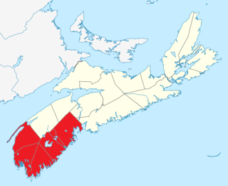
Southern Nova Scotia or the South Shore is a region of Nova Scotia, Canada. The area has no formal identity and is variously defined by geographic, county and other political boundaries. Statistics Canada, defines Southern Nova Scotia as an economic region, composed of Lunenburg County, Queens County, Shelburne County, Yarmouth County, and Digby County. According to Statistics Canada, the region had the highest decrease of population in Canada from 2009 to 2010, with a population decrease of 10.2 residents per thousand. The region also has the second-highest median age in Canada at 47.1 years old.

A township in Nova Scotia, Canada, was an early form of land division and local administration during British colonial settlement in the 18th century. They were created as a means of populating the colony with people loyal to British rule. They were typically rural or wilderness areas of around 100,000 acres (400 km2) that would eventually include several villages or towns. Some townships, but not all, returned a member to the General Assembly of Nova Scotia; others were represented by the members from the county. Townships became obsolete by 1879 by which time towns and counties had become incorporated.
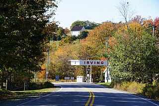
| | This Hants County, Nova Scotia location article is a stub. You can help Wikipedia by expanding it. |