Related Research Articles

In aviation, instrument flight rules (IFR) is one of two sets of regulations governing all aspects of civil aviation aircraft operations; the other is visual flight rules (VFR).
In aviation, visual flight rules (VFR) are a set of regulations under which a pilot operates an aircraft in weather conditions generally clear enough to allow the pilot to see where the aircraft is going. Specifically, the weather must be better than basic VFR weather minima, i.e. in visual meteorological conditions (VMC), as specified in the rules of the relevant aviation authority. The pilot must be able to operate the aircraft with visual reference to the ground, and by visually avoiding obstructions and other aircraft.

Airspace is the portion of the atmosphere controlled by a country above its territory, including its territorial waters or, more generally, any specific three-dimensional portion of the atmosphere. It is not the same as aerospace, which is the general term for Earth's atmosphere and the outer space in its vicinity.

In the United States, airways or air routes are defined by the Federal Aviation Administration (FAA) in two ways:

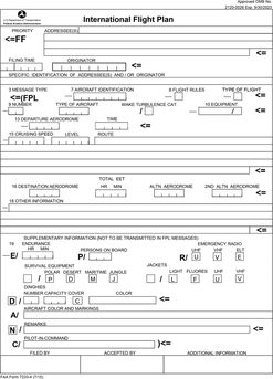
Flight plans are documents filed by a pilot or flight dispatcher with the local Air Navigation Service Provider prior to departure which indicate the plane's planned route or flight path. Flight plan format is specified in ICAO Doc 4444. They generally include basic information such as departure and arrival points, estimated time en route, alternate airports in case of bad weather, type of flight, the pilot's information, number of people on board and information about the aircraft itself. In most countries, flight plans are required for flights under IFR, but may be optional for flying VFR unless crossing international borders. Flight plans are highly recommended, especially when flying over inhospitable areas, such as water, as they provide a way of alerting rescuers if the flight is overdue. In the United States and Canada, when an aircraft is crossing the Air Defense Identification Zone (ADIZ), either an IFR or a special type of VFR flight plan called a DVFR flight plan must be filed. For IFR flights, flight plans are used by air traffic control to initiate tracking and routing services. For VFR flights, their only purpose is to provide needed information should search and rescue operations be required, or for use by air traffic control when flying in a "Special Flight Rules Area".
In general aviation, scud running is a practice in which pilots lower their altitude to avoid clouds or instrument meteorological conditions (IMC). The goal of scud running is to stay clear of weather to continue flying with visual, rather than instrument, references. This practice is widely accepted to be dangerous, and has led to death in many cases from pilots flying into terrain or obstacles, such as masts and towers, normally referred to as CFIT; however, even instrument-rated pilots sometimes elect to take the risk to avoid icing or embedded thunderstorms in cloud, or in situations where the minimum instrument altitudes are too high for their aircraft.

A flight service station (FSS) is an air traffic facility that provides information and services to aircraft pilots before, during, and after flights, but unlike air traffic control (ATC), is not responsible for giving instructions or clearances or providing separation. They do, however, relay clearances from ATC for departure or approaches. The people who communicate with pilots from an FSS are referred to as flight service specialists.
Special visual flight rules are a set of aviation regulations under which a pilot may operate an aircraft. It is a special case of operating under visual flight rules (VFR).
A pilot report or PIREP is a report of actual weather conditions encountered by an aircraft in flight. This information is usually relayed by radio to the nearest ground station, but other options also exist in some regions. The message would then be encoded and relayed to other weather offices and air traffic service units.
A UNICOM station is an air-ground communication facility operated by a non-air traffic control private agency to provide advisory service at uncontrolled aerodromes and airports and to provide various non-flight services, such as requesting a taxi, even at towered airports. It is also known as an aeronautical advisory station. The equivalent European/ICAO service is known as (aerodrome) flight information service, abbreviated as AFIS or FIS.

In aviation, a non-towered airport is an airport without a control tower, or air traffic control (ATC) unit. The vast majority of the world's airports are non-towered. In the United States, there are close to 20,000 non-towered airports compared to approximately 500 airports with control towers. Airports with a control tower without 24/7 ATC service follow non-towered airport procedures when the tower is closed but the airport remains open, for example at night.

Iowa City Municipal Airport, is two miles southwest of Iowa City, in Johnson County, Iowa. It is the oldest civil airport west of the Mississippi River still in its original location.

West Bend Municipal Airport is a city-owned public-use airport located three nautical miles (6 km) east of the central business district of West Bend, a city in Washington County, Wisconsin, United States. It is included in the Federal Aviation Administration (FAA) National Plan of Integrated Airport Systems for 2021–2025, in which it is categorized as a regional reliever airport facility.

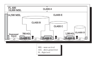
The United States airspace system's classification scheme is intended to maximize pilot flexibility within acceptable levels of risk appropriate to the type of operation and traffic density within that class of airspace – in particular to provide separation and active control in areas of dense or high-speed flight operations.
An Aviation Area Forecast was a message product of the National Weather Service (NWS) in the United States. It has been replaced by Graphic Area Forecasts, or GFA, in 2017.
ATC Zero is an official term used by the U.S. Federal Aviation Administration (FAA) that means the FAA is unable to safely provide the published ATC services within the airspace managed by a specific facility. The term is always used in conjunction with a facility reference. FAA ATC facilities include Air Route Traffic Control Centers (ARTCC); Terminal Radar Control facility (TRACON), Air Traffic Control Tower (ATCT), Flight Service Stations (FSS), or the Air Traffic Control System Command Center (ATCSCC). The term is defined in FAA Order JO 1900.47, Air Traffic Control Operational Contingency Plans. It is one of three designations used by the FAA to describe degraded operations and invoke operational contingency plans.
The National Airspace System (NAS) is the airspace, navigation facilities and airports of the United States along with their associated information, services, rules, regulations, policies, procedures, personnel and equipment. It includes components shared jointly with the military. It is one of the most complex aviation systems in the world, and services air travel in the United States and over large portions of the world's oceans.

Automatic Dependent Surveillance–Broadcast (ADS–B) is a surveillance technology in which an aircraft determines its position via satellite navigation or other sensors and periodically broadcasts it, enabling it to be tracked. The information can be received by air traffic control ground stations as a replacement for secondary surveillance radar, as no interrogation signal is needed from the ground. It can also be received by other aircraft to provide situational awareness and allow self-separation. ADS–B is "automatic" in that it requires no pilot or external input. It is "dependent" in that it depends on data from the aircraft's navigation system.

On August 8, 2009, at 11:53 a.m. (15:53 UTC), nine people died when a tour helicopter and a small private airplane collided over the Hudson River near Frank Sinatra Park in Hoboken, New Jersey. The aircraft were in an area known as the "Hudson River VFR Corridor", which extends from the surface of the river to altitudes of 800 to 1,500 feet at various locations along the Hudson River in the immediate area of New York City. Within this corridor, aircraft operate under visual flight rules (VFR), under which the responsibility to see and avoid other air traffic rests with the individual pilots rather than with the air traffic controller.
AirNav.com is a privately owned website for pilots and aviation enthusiasts. The site publishes aeronautical and airport information released by the Federal Aviation Administration (FAA) such as runway distances, airfield traffic patterns, airport frequencies, airport operations, facilities and services, chart location, navigational coordinates and locations, radio aids, ownership information and other pertinent information that all pilots need when traveling into or out of an airport or around the United States National Airspace System (NAS). The same information is published in the Airport/Facility Directory (A/FD), updated every 56 days.
References
- ↑ "FAR/AIM 7-1-20. Pilot Weather Reports (PIREPs) c." FAA. 2014-04-03.
- ↑ "FAA Order JO 7110.10V, Flight Services, Ch. 4, Section 6, En Route Flight Advisory Service (EFAS)". FAA. 2012-02-09. Archived from the original on 2012-06-04. Retrieved 2012-06-01.
- ↑ "Oct. 1 end date for 'Flight Watch' frequency 122.0". AOPA. 2015-08-18. Retrieved 2015-11-28.