Related Research Articles

Bangladesh, officially the People's Republic of Bangladesh, is a country in South Asia. It is the eighth-most populous country in the world and seventh most densely populated with a population of 173,562,364 in an area of 148,460 square kilometres (57,320 sq mi). Bangladesh shares land borders with India to the north, west, and east, and Myanmar to the southeast. To the south, it has a coastline along the Bay of Bengal. To the north, it is separated from Bhutan and Nepal by the Siliguri Corridor, and from China by the mountainous Indian state of Sikkim. Dhaka, the capital and largest city, is the nation's political, financial, and cultural centre. Chittagong is the second-largest city and the busiest port. The official language is Bengali, with Bangladeshi English also used in government.

Dhaka, formerly known as Dacca, is the capital and largest city of Bangladesh. It is the ninth-largest and seventh-most densely populated city in the world with a density of 23,234 people per square kilometer within a total area of approximately 300 square kilometers. Dhaka is a megacity, and has a population of 10.2 million residents as of 2024, and a population of over 23.9 million residents in Dhaka Metropolitan Area. It is widely considered to be the most densely populated built-up urban area in the world. Dhaka is the most important cultural, economic, and scientific hub of Eastern South Asia, as well as a major Muslim-majority city. Dhaka ranks third in South Asia and 39th in the world in terms of GDP. Lying on the Ganges Delta, it is bounded by the Buriganga, Turag, Dhaleshwari and Shitalakshya rivers. Dhaka is also the largest Bengali-speaking city in the world.

Bangladesh is a densely populated, low-lying, mainly riverine country located in South Asia with a coastline of 580 km (360 mi) on the northern littoral of the Bay of Bengal. The delta plain of the Ganges (Padma), Brahmaputra (Jamuna), and Meghna Rivers and their tributaries occupy 79 percent of the country. Four uplifted blocks occupy 9 percent and steep hill ranges up to approximately 1,000 metres (3,300 ft) high occupy 12 percent in the southeast and in the northeast. Straddling the Tropic of Cancer, Bangladesh has a tropical monsoon climate characterised by heavy seasonal rainfall, high temperatures, and high humidity. Natural disasters such as floods and cyclones accompanied by storm surges periodically affect the country. Most of the country is intensively farmed, with rice the main crop, grown in three seasons. Rapid urbanisation is taking place with associated industrial and commercial development. Exports of garments and shrimp plus remittances from Bangladeshis working abroad provide the country's three main sources of foreign exchange income.
The National Weather Service (NWS) is an agency of the United States federal government that is tasked with providing weather forecasts, warnings of hazardous weather, and other weather-related products to organizations and the public for the purposes of protection, safety, and general information. It is a part of the National Oceanic and Atmospheric Administration (NOAA) branch of the Department of Commerce, and is headquartered in Silver Spring, Maryland, within the Washington metropolitan area. The agency was known as the United States Weather Bureau from 1890 until it adopted its current name in 1970.

The Meteorological Office, abbreviated as the Met Office, is the United Kingdom's national weather and climate service. It is an executive agency and trading fund of the Department for Science, Innovation and Technology and is led by CEO Penelope Endersby, who took on the role as Chief Executive in December 2018 and is the first woman to do so. The Met Office makes meteorological predictions across all timescales from weather forecasts to climate change.
The Environment Agency (EA) is a non-departmental public body, established in 1996 and sponsored by the United Kingdom government's Department for Environment, Food and Rural Affairs, with responsibilities relating to the protection and enhancement of the environment in England.

Sylhet is a metropolitan city located in the northeastern region of Bangladesh. It is the administrative center of Sylhet Division and is situated on the banks of the Surma River. Sylhet is the fifth-largest city in Bangladesh, with a population of around 530,000 people in 2022.

Hussain Muhammad Ershad was a Bangladeshi military officer and politician who served as the president of Bangladesh from 1982 to 1990.
The Bureau of Meteorology is an executive agency of the Australian Government responsible for providing weather services to Australia and surrounding areas. It was established in 1906 under the Meteorology Act, and brought together the state meteorological services that existed before then. The states officially transferred their weather recording responsibilities to the Bureau of Meteorology on 1 January 1908.
The Philippine Atmospheric, Geophysical and Astronomical Services Administration is the National Meteorological and Hydrological Services (NMHS) agency of the Philippines mandated to provide protection against natural calamities and to ensure the safety, well-being and economic security of all the people, and for the promotion of national progress by undertaking scientific and technological services in meteorology, hydrology, climatology, astronomy and other geophysical sciences. Created on December 8, 1972, by reorganizing the Weather Bureau, PAGASA now serves as one of the Scientific and Technological Services Institutes of the Department of Science and Technology.

Gulshan is a thana situated in Dhaka, Bangladesh. It is an affluent residential and business neighbourhood and is now home to a number of the city's restaurants, five star hotels, shopping centers, schools, banks, offices and members' clubs; it also hosts the majority of embassies and high commissions in Bangladesh. Many Bangladeshi and international companies have their offices in Gulshan.
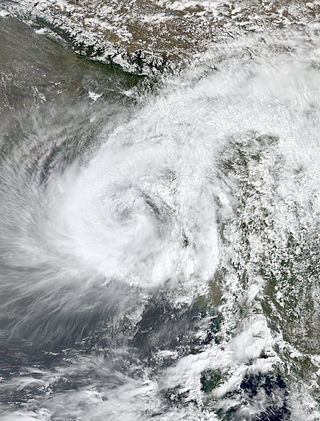
Cyclonic Storm Akash was the first named tropical cyclone of the 2007 North Indian Ocean cyclone season. Warned by both India Meteorological Department (IMD) and Joint Typhoon Warning Center (JTWC), it formed from an area of disturbed weather on the Bay of Bengal on May 12, and gradually organized as it drifted northward. An eye began to develop as it approached land, and after reaching peak 3-min sustained winds of 85 km/h (55 mph) it struck about 115 km (71 mi) south of Chittagong in Bangladesh. Akash rapidly weakened over land, and advisories were discontinued on May 15.

Extremely Severe Cyclonic Storm Sidr was a tropical cyclone that resulted in one of the worst natural disasters in Bangladesh. The fourth named and the deadliest storm of the 2007 North Indian Ocean cyclone season, Sidr formed in the central Bay of Bengal, and quickly strengthened to reach peak 1-minute sustained winds of 260 km/h (160 mph), making it a Category-5 equivalent tropical cyclone on the Saffir–Simpson scale. The storm eventually made landfall in Bangladesh on November 15, 2007, causing large-scale evacuations. At least 3,447 deaths have been blamed on the storm, with some estimates reaching 15,000.

Severe Cyclonic Storm Aila was the second named tropical cyclone of the 2009 North Indian Ocean cyclone season. Warned by both the Regional Specialized Meteorological Center (RMSC) and Joint Typhoon Warning Center (JTWC), Aila formed over a disturbance over the Bay of Bengal on May 23, 2009 and started to intensify and organize reaching sustained wind speeds of 110 kmh (70 mph). It was the worst natural disaster to affect Bangladesh since Cyclone Sidr in November 2007. A relatively strong tropical cyclone, it caused extensive damage in India and Bangladesh.
The Flood Forecasting Centre (FFC) is a joint venture between the Environment Agency and the Met Office to provide improved flood risk guidance for England and Wales. The FFC is based in the Operations Centre at the Met Office headquarters in Exeter and is jointly staffed from both organisations.

The Dhaka Metro Rail, or simply the Dhaka Metro, is a mass rapid transit system serving Dhaka, the capital and largest city of Bangladesh. It is operated by the Dhaka Mass Transit Company Limited (DMTCL). Together with the under construction Dhaka BRT, proposed Dhaka Subway and Dhaka suburban circular rail, it is expected to reduce traffic congestion in the city. The metro rail network has five planned lines which are the MRT Line 6, the only operational line, MRT Line 1 and MRT line 5, which are under construction, and MRT Line 2 and MRT Line 4, which are in the planning stages. It is part of the Strategic Transport Plan outlined by the Dhaka Transport Coordination Authority (DTCA).

Regional Meteorological Centre, Chennai is one of the six regional meteorological centres (RMCs) of the India Meteorological Department (IMD) and is responsible for the weather-related activities of the southern Indian peninsula comprising the states of Andhra Pradesh, Telangana, Karnataka, Kerala, Tamil Nadu and the union territories of Andaman and Nicobar, Lakshadweep Islands and Puducherry. The other regional centres are located at Kolkata, Guwahati, Mumbai, Nagpur and New Delhi.

The Ministry of Water Resources is a ministry of the government of the People's Republic of Bangladesh, which formulates all kinds of policies, plans, strategies, guidelines and laws, rules, regulations, etc. for the development and management of water resources and the management and control of the departments under its jurisdiction. This ministry prepares and implements development projects on flood control, irrigation and drainage, prevention of riverbank erosion, delta development, land reclamation, etc. through the construction of barrages, regulators, sluices, canals, embankments, rubber dams, flood control dams, coastal embankments and canals. Excavation-re-excavation provides services such as irrigation, flood control, flood prevention, river bank erosion prevention, land reclamation etc.

Severe Cyclonic Storm Mora was a moderate but deadly tropical cyclone that caused widespread devastation and severe flooding in Sri Lanka, Andaman and Nicobar Islands, Bangladesh, Myanmar and Northeast India in May 2017. The second named storm of the 2017 annual cyclone season, Mora developed from an area of low pressure over the southeastern Bay of Bengal on May 28. Mora reached peak strength with maximum sustained winds of 110 km/h (70 mph). The cyclone made landfall near Chittagong on the morning of May 30 and steadily weakened, dissipating early in the morning on May 31. Across its path, Mora dropped a large amount of rain, including 225mm of rainfall in Chittagong and northeast India. The storm is estimated to have caused damages nearing US$300 million.

Beginning in May 2022, deadly floods hit northeastern India and Bangladesh. Over 9 million people in both countries have been affected, and around 300 people were killed.
References
- ↑ "Mission". ffwc.gov.bd. Archived from the original on 4 October 2017. Retrieved 4 October 2017.
- ↑ "Satellite Data Is Saving Lives with Flood Forecasting in Bangladesh". usaid.gov. Archived from the original on 4 October 2017. Retrieved 4 October 2017.
- ↑ "Early Flood Warning Saves Lives". The Daily Star. 11 March 2017. Retrieved 4 October 2017.
- ↑ "Floods in Bangladesh: The way forward". The Daily Star. 6 November 2007. Retrieved 4 October 2017.
- ↑ Bharati, Luna; Sharma, Bharat R.; Smakhtin, Vladimir (2016). The Ganges River Basin: Status and Challenges in Water, Environment and Livelihoods. Routledge. ISBN 9781317479475 . Retrieved 4 October 2017.
- ↑ "Anisul warns of severe flood next month". The Daily Star. 27 July 2017. Retrieved 4 October 2017.
- ↑ Singh, Ashbindu; Zommers, Zinta (2014). Reducing Disaster: Early Warning Systems For Climate Change. Springer. p. 170. ISBN 9789401785983 . Retrieved 4 October 2017.
- ↑ "Flood Bulletin (FFWC)" (PDF). FFWC. 17 June 2023. Retrieved 17 June 2023.
| | This article about a Bangladeshi organisation is a stub. You can help Wikipedia by expanding it. |