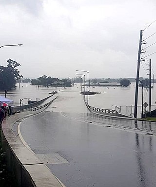
Floods in Greymouth

Last updated

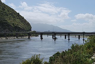
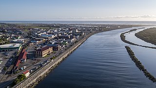
The town of Greymouth, at the mouth of the Grey River on New Zealand's West Coast, has been regularly flooded since its founding. [1] Many floods were assigned names, such as: The Great Flood (1872); The Jubilee Flood (1887); The Big Flood (1905); The Biggest Since 1887 (1936); The Biggest Since 1936 (1977); The Big One (May 1988); and The Biggest (September 1988). [2] :81 A flood protection wall was completed in 1990, and the town has not since experienced flooding from the river.

Contents

Historic floods

The Great Flood (1872)

1872 Greymouth Flood Hh-Greymouth-Floods-003 1872.jpg
1872 Greymouth Flood

This flood occurred on 9 February 1872 after a week of heavy rain combined with heavy seas along the coast. The high sea exacerbated the situation as the flood waters were prevented from draining away and consequently backed up. [3] Richmond Quay was the most affected area; whole blocks of offices, shops and other structures were washed out to sea. [4] Dozens of houses were lifted off their piles and floated down the river, their kerosene lamps still burning. As soon as they crossed the Bar however, the lights were extinguished and the houses broken into matchwood by the sea. One life was lost, the youngest son of William Dale was drowned. [5] The flood did a great deal of damage and extended over a wide area. Luckily the Prime Minister, Sir William Fox, was visiting Westport on the night of the flood. He travelled to Greymouth the next day and made an inspection, ordering the building of a protective wall which was completed in 1885 [2] :81 at a cost of five thousand pounds. [4]

The Jubilee Flood (1887)
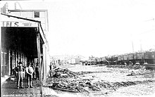
1887 Greymouth Flood Hh-Greymouth-Floods-053 Jubille Flood 1887.jpg
1887 Greymouth Flood

Wednesday 6 July 1887 witnessed the worst flooding in Greymouth since the great flood of 1872 with water reaching two feet higher. Water invaded many homes with hundreds made homeless, needing to seek refuge in churches and in the State School. [4] Flood waters overflowed the wharf and 9.00am, peaked at noon, and receded by dusk. Every business and house along Māwhera Quay was flooded to a depth of at least 1 metre and boats were needed to rescue people between 3.00am and 10.00am. At its peak the river nearly touched the base of the Cobden Bridge; the water level in the mid-channel area was reported to be about 1 metre higher than at the banks. [6]

The Big Flood (1905)
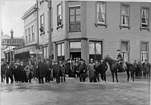
1905 Greymouth Flood Hh-Greymouth-Floods-001 1905.jpg
1905 Greymouth Flood

At 4am on Saturday 24 June 1905 the firebell sounded the alarm bringing businessmen rushing to their premises to lift goods from floor level. Many people had kept watch on the Friday night but although there was a howling gale and heavy rain, the river did not give the indications of the forthcoming heavy flood. It rose rapidly however in the following two hours and was lapping the wharf at 5am. All the main streets of the town were flooded with the current in Māwhera Quay a raging torrent.

In the twenty-four hours between 9am on Friday to 9am on Saturday 4+34 inches (120 mm) of rain fell at Greymouth, even more in the country areas. At Bealey 11 inches (280 mm) were recorded. In spite of the falling tide, the river continued to rise and from 11am to 2pm it was at its height.

The borough engineer, Mr E. I. Lord, took a desperate step to relieve the pressure of water backing up into the town area. At about 10am he sent a gang of workmen to the Blaketown area. Near the site of the old powder magazine, a channel was cut between the lagoon and the sea and helped prevent even worse damage to the town.

The work of rescuing was accomplished with boats and vehicles with great difficulty getting some families out of their flood-surrounded homes. The whole of the Greymouth business area was under water. In the quay below Tainui Street and in Mackay Street, Hospital (now Guinness Street), Boundary and Albert Streets and Richmond Quay, dangerously deep streams were rushing down, tearing the thoroughfare up in all directions. The water was rushing over the top of the wharf and tearing away the embankments, undermining and destroying the railway tracks along Māwhera Quay.

The Brian Boru, Albion, Club, Caledonian, Commercial, Imperial, Oriental and Criterion Hotels all faced the full force of the rushing water as it poured over the wharf. The Imperial Hotel had a concrete cellar and as there was no means of getting rid of the water, one of the fire brigade's manual pumps was brought in on Monday morning.

Though the ships in port had a trying time at the height of the flood, no damage was reported. One large snag was caught in the wharf between the hydraulic cranes but this was removed on Monday afternoon. The Greymouth Bar which had been shallow for a number of weeks, had 24 feet of water with a straight channel to sea. In consequence, shipping movements were unhampered, vessels taking away full cargoes.

At Coal Creek several settlers lost nearly all their stock while several of them, with their families, were perched on the tops of buildings until mid-day on Saturday before being rescued. Further up the Grey Valley, settlers were heavy losers, large numbers of cattle, sheep and horses being drowned.

Railway traffic was completely suspended with a number of wash-outs on the Greymouth-Reefton and Greymouth-Otira lines. There was one wash-out on the Greymouth-Hokitika line but traffic on this section resume on the Saturday afternoon.

The water began to recede about 4pm and by 10pm the main thoroughfares in the town were clear. Huge holes had been torn in the main streets and the estimated cost of repairs was 500 pounds. The flood proved disastrous for the district as the completion of the railway was postponed indefinitely. An embankment in the form of a wing dam, a distance of 10 or 12 chains and almost a year's work, was completely levelled. The damage here was estimated at 2,000 pounds. [2] :84–87

Biggest Since 1887 (1936)

1936 Greymouth Flood Hh-Greymouth-Floods-070 Tainui St 1936.jpg
1936 Greymouth Flood

What was described as a once in 50 year flood, Greymouth felt the effects of 55 mm of rain over a 36 hour period, 35 mm of which fell in six hours causing the Grey River to breach its banks on Saturday, 10 October 1936. The rising floodwaters, backed up by the tide, forced gaping holes in the railway ballast and protection works at the lower end of the town. Within a comparatively short time the waters had reached as far as the railway line, extending from Tainui Street to Karoro. For over five hours the raging river continued to overflow. With the fall of the tide shortly after 9 o'clock, the situation eased and the waters started receding until noon when little water remained on the streets in the business area.

There were no deaths but many narrow escapes were recorded, rescue work being done by many who secured rowboats.

When the waters cleared, a thick layer of silt covered the inundated areas. Great as was the loss in Greymouth, it was a fraction of the enormous damage in the Grey Valley. Thousands of pounds worth of stock was swept down the Grey River and its tributaries, some farmers losing hundreds of pounds worth.

At its height in this flood, the Grey River was running at 12 knots (22 km/h). Older residents, who retained marks on the walls of their homes, indicated that the waters were 9 inches (230 mm) higher than in 1913. [2] :87–88

Biggest Since 1936 (1977)

On Tuesday, 18 January 1977 the Grey River burst its banks at 1.30am sending a torrent of water through the main business area. A state of civil emergency was declared by the district civil defence controller, Mayor O. H. Jackson at 3.30am. The flooding was described as the worst in Greymouth since the big flood in March 1936.

The burst bank occurred almost opposite the Tainui Street – Māwhera Quay corner, flooding dozens of shops, hotels and other businesses. Blaketown, Cobden and the Arney-Leonard Street area bore the brunt of the damage to homes and about 40 people had to be evacuated. Flood water was five feet deep in some houses. Mayor Jackson closed the town centre to sightseers although some businesses re-opened by mid-afternoon.

The state of emergency was in place until 4pm on Saturday 22 January to allow the town centre to be cleared of silt. Mr Jackson saw this flood proved the need for a flood protection wall. [2] :88–89

The Big One (May 1988)

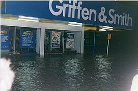
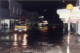
In 1988 flooding occurred in May and September. The May event brought flooding to the entire West Coast, particularly the Greymouth area. On the morning of 19 May, warnings were broadcast that up to 150mm of rain was expected in the Greymouth area, and with heavy rain already falling in the back country, this posed a serious threat of flooding. By 5pm the rivers up country were running approximately a foot higher than the level of the November 1984 flood. It was predicted the Grey River would come over the wharf at 10pm. At 8.30pm it was decided to close the town from the railway crossings at Herbert, Tarapuhi, Albert and Tainui Streets and Māwhera Quay. By 9pm the lagoons were overflowing and water entering houses and businesses in Blaketown and the lower town areas. Water was pouring through the Richmond Hotel at 9.20pm. The river was running at 14.5 knots against a heavy sea. [2] :89–90

A Civil Defence Emergency was declared for the Greymouth Borough on 20 May, and roads and properties suffered damage. Four hundred people had to be evacuated with 102 houses affected and 2 being condemned. [7]

The Biggest One (September 1988)

On Monday 12 September 1988 farmers were warned to move stock to high ground. The Meteorological Service advised that up to 250mm of rain would fall in the region over a 36 hour period. By mid afternoon, all rivers and creeks in the Grey catchment rose rapidly over the next few hours. By 8.30am on Tuesday 13 September the river was spilling its banks at Richmond Quay, the Blaketown lagoons were overflowing and water was starting to enter houses. Heavy seas combined with a high tide left no doubt the flooding would be disastrous. When the river peaked about 3.35pm it was overflowing its banks from the Cobden Bridge to the Railways goods shed in Gresson Street to a depth of one metre. The Greymouth aerodrome runways were under more than a metre of water and the basement of the Greymouth Hospital was flooded. The whole town was a lake. Over 300 people had to be evacuated, many by jet boat from Blaketown, Kaiata and Coal Creek.

Statue commemorating volunteer work in the 1988 floods Greymouth Statue A 001 (cropped).JPG
Statue commemorating volunteer work in the 1988 floods

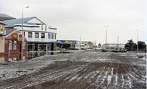
A state of regional civil emergency was declared. The flooding caused two massive landslips, one of which claimed the life of Rewanui mine site caretaker, Keith Butler, as it swept away the old bath house there. Overall damage was extensive: there were broken stormwater, sewerage and high pressure service lines, smashed shop windows and goods scattered throughout the town which was inches deep in silt, much of it contaminated with oil and sewage. For several days the town was under curfew to allow the cleanup to proceed. [2] :90

Flood protection

After the floods of 1988, the mayor of Greymouth, Barry Dallas, embarked on an ambitious project to build a flood protection wall. The wall was completed in September 1990 at an overall cost of NZ$4m: 80% from the New Zealand government and 20% from Grey District Council. [1] Since its completion, river flooding has not affected the town again. [8] To commemorate the work of the hundreds of locals who helped sandbag, fruitlessly, against the 1988 floods, and who assisted in the cleanup afterwards, the town erected a statue of a fisherman on the new flood wall. Cast in concrete by local sculptor Stephan Newby, a plaque at its base has the dedication "To those who help others". [4]

Related Research Articles

<span class="mw-page-title-main">Greymouth</span> Town in West Coast, New Zealand

Greymouth is the largest town in the West Coast region in the South Island of New Zealand, and the seat of the Grey District Council. The population of the whole Grey District is 14,200, which accounts for 43% of the West Coast's inhabitants. The Greymouth urban area had an estimated population of 8,320. A large proportion of the District, 65%, is part of the Conservation Estate owned and managed by the Department of Conservation making Greymouth a natural centre for walkers and trampers.

<span class="mw-page-title-main">Grey River (New Zealand)</span> River in the South Island of New Zealand

The Grey River / Māwheranui is located in the northwest of the South Island of New Zealand. It rises 12 kilometres southwest of the Lewis Pass in Lake Christabel, one of numerous small lakes on the western side of the Southern Alps, and runs westward for 120 kilometres before draining into the Tasman Sea at Greymouth. Thomas Brunner, who explored the area in the late 1840s, named the river in honour of Sir George Grey, who first served as Governor of New Zealand from 1845 to 1854. The Ngāi Tahu Claims Settlement Act 1998 changed the official name of the river to Grey River / Māwheranui in 1998. The Māori name for the river system and surrounding area is Māwhera, with Māwheranui being distinguished from the northern branch Little Grey River / Māwheraiti.

<span class="mw-page-title-main">Grey District</span> Territorial authority district in West Coast Regional Council, New Zealand

Grey District is a district in the West Coast Region of New Zealand that covers Greymouth, Runanga, Blackball, Cobden, and settlements along the Grey River. It has a land area of 3,474.44 square kilometres (1,341.49 sq mi). The seat of the Grey District Council, the local government authority that administers the district, is at Greymouth, where 58.6% of the district's population live.

<span class="mw-page-title-main">Hurricane Bertha (1996)</span> Category 3 Atlantic hurricane in 1996

Hurricane Bertha was an intense and early-forming major hurricane that affected areas from the Leeward Islands to the United States in July of the 1996 Atlantic hurricane season. The second named storm, first hurricane, and first major hurricane during the season. Bertha originated from a tropical wave that moved off the coast of Africa in early July. Steadily organizing while moving generally towards the west, the disturbance was designated as a tropical depression at 0000 UTC on July 5, and was further upgraded to a tropical storm by 1200 UTC later that day. Over the next few days, continued intensification occurred, and Bertha became a Category 1 hurricane on the Saffir-Simpson hurricane scale, the first hurricane of the season, prior to moving through the northern Leeward Islands. Late on July 8, a period of rapid intensification began, and at 0600 UTC on July 9, Bertha reached its peak intensity with maximum sustained winds of 115 mph (185 km/h) with a minimum barometric pressure of 960 mbar (28 inHg). Moving around the western periphery of the subtropical ridge, Bertha passed north of the Bahamas as a weakening hurricane before turning towards the north-northeast and undergoing another period of rapid intensification. Late on July 12, Bertha made landfall between Wrightsville Beach and Topsail Beach, North Carolina with winds of 105 mph (169 km/h). Gradual weakening ensued the following day as Bertha moved up the Mid-Atlantic and into New England before becoming an extratropical cyclone on July 14. The storm's remnants persisted for another several days, before dissipating on July 18.

<span class="mw-page-title-main">Tropical Storm Alberto (1994)</span>

Tropical Storm Alberto produced extensive flooding over portions of Alabama, Georgia, and Florida in July 1994. The first tropical cyclone and named storm of the annual hurricane season, Alberto developed from a tropical wave over the northwestern Caribbean Sea on June 30. Initially a tropical depression, the system moved westward, before curving northwestward on July 1 and entering the Gulf of Mexico. Early on the following day, the depression intensified into Tropical Storm Alberto. Alberto strengthened steadily over the Gulf of Mexico, and by midday on July 3, it peaked as a strong tropical storm with maximum sustained winds of 65 mph (100 km/h). A few hours later, the cyclone made landfall near Destin, Florida, at the same intensity. The system quickly weakened to a tropical depression early on July 4. Thereafter, a high pressure system caused Alberto to drift over west-central Georgia and central Alabama, until the storm dissipated over Alabama on July 7.

<span class="mw-page-title-main">1939 California tropical storm</span> Category 1 Pacific hurricane in 1939

The 1939 California tropical storm, also known as the 1939 Long Beach tropical storm, and El Cordonazo, was a tropical cyclone that affected Southern California in September 1939. Formerly a hurricane, it was the only tropical storm to make landfall in California in the twentieth century. Fisherman in the villages along the Mexican coast have named these storms, the Lash of St. Francis. The only other known tropical cyclone to directly affect California at tropical storm intensity or higher is the 1858 San Diego hurricane, and only three other eastern Pacific tropical cyclones have produced gale-force winds in the continental United States. The tropical storm caused heavy flooding, leaving many dead, mostly at sea.

<span class="mw-page-title-main">Hurricane Gordon (2000)</span> Category 1 Atlantic hurricane in 2000

Hurricane Gordon caused minor damage in the Eastern United States. The seventh named storm and fourth hurricane of the 2000 Atlantic hurricane season, Gordon developed in the extreme western Caribbean Sea from a tropical wave on September 14. Shortly thereafter, the depression moved inland over the Yucatán Peninsula and later emerged into the Gulf of Mexico on September 15. The depression began to quickly organize, and by early on September 16, it was upgraded to Tropical Storm Gordon. After becoming a tropical storm, Gordon continued to intensify and was reclassified as a hurricane about 24 hours later; eventually, the storm peaked as an 80 mph (130 km/h) Category 1 hurricane. However, southwesterly upper-level winds caused Gordon to weaken as it approached land, and it was downgraded to a tropical storm by late on September 17. At 0300 UTC on September 18, Gordon made landfall near Cedar Key, Florida as a strong tropical storm. After moving inland, Gordon rapidly weakened and had deteriorated to tropical depression status by nine hours later. Later that day, Gordon merged with a frontal boundary while centered over Georgia.

Floods in the United States are generally caused by excessive rainfall, excessive snowmelt, and dam failure. Below is a list of flood events that were of significant impact to the country during the 20th century, from 1900 through 1999, inclusive.

<span class="mw-page-title-main">2004 Boscastle flood</span> Flooding event in Boscastle, England

The 2004 Boscastle flood occurred on Monday, 16 August 2004 in the two villages of Boscastle and Crackington Haven in Cornwall, England, United Kingdom. The villages suffered extensive damage after flash floods caused by an exceptional amount of rain that fell over eight hours that afternoon. The flood in Boscastle was filmed and extensively reported but the floods in Crackington Haven and Rocky Valley were not mentioned beyond the local news. The floods were the worst in local memory. A study commissioned by the Environment Agency from hydraulics consulting firm HR Wallingford concluded that it was among the most extreme ever experienced in Britain. The peak flow was about 140 m3/s, between 5:00 pm and 6:00 pm BST. The annual chance of this flood in any one year is about 1 in 400. The probability each year of the heaviest three-hour rainfall is about 1 in 1300. At midday on 16 August 2004, heavy thundery showers had developed across the South West due to a weak disturbance to the northeast of the United Kingdom.

<span class="mw-page-title-main">June 2008 Midwest floods</span> Weather outbreak that lead to flooding in the American Midwest

The June 2008 Midwestern United States floods were flooding events which affected portions of the Midwestern United States. After months of heavy precipitation, a number of rivers overflowed their banks for several weeks at a time and broke through levees at numerous locations. Flooding continued into July. States affected by the flooding included Illinois, Indiana, Iowa, Michigan, Minnesota, Missouri and Wisconsin. The American Red Cross assisted the victims of flooding and tornadoes across seven states and the National Guard was mobilized to assist in disaster relief and evacuation.

<span class="mw-page-title-main">2008 Ireland floods</span>

The 2008 Irish flash floods were a series of flash floods that occurred across the island of Ireland in August 2008. The floods and related weather conditions primarily affected the following counties; Limerick, Cork, Dublin, Antrim, Carlow, Galway, Laois, Louth, Meath, Kildare, Kilkenny, Tipperary, Offaly, Sligo and Donegal. Parts of Ireland's large urban centres, including Dublin and Belfast, were submerged, whilst Carlow town has experienced some of the worst flooding in the country. One person died; 31-year-old dad-of-one Przemyslaw Jablonski. He went missing in the River Fergus, in Ennis, and was found 6 days later in the same river. He was pronounced dead at the scene.

<span class="mw-page-title-main">Hurricane Waldo</span> Category 2 Pacific hurricane in 1985

Hurricane Waldo was a Pacific hurricane whose remnants caused significant flooding in Kansas during October 1985. It was also the only hurricane to make landfall during the extremely active 1985 Pacific hurricane season. The twenty-fourth tropical cyclone, twenty-second named storm, and eleventh hurricane of the season, Waldo originated from a disturbance first detected by ship report on October 5, 1985. After developing into a tropical depression on October 7, it steadily intensified, becoming a tropical storm that day. Waldo reached hurricane intensity on October 8. After peaking as a moderate Category 2 hurricane on the Saffir–Simpson hurricane scale, it re-curved to the east, making landfall at peak intensity near Culiacán. Afterward, it rapidly dissipated. In all, Waldo caused moderate damage in Sonora. The remnants of the storm combined with a cold front over the Great Plains. Significant flooding and one death was recorded in Kansas. Many rivers and creeks overflowed its banks.

The 1998 Townsville and Thuringowa city floods began on 10 January 1998, the cities of Townsville and Thuringowa were hit by one of the worst floods in the cities' history.

<span class="mw-page-title-main">North Sea flood of 1978</span> Storm surge on the east coast of England

North Sea flood of 1978 was a storm surge which occurred over 11–12 January causing extensive coastal flooding and considerable damage on the east coast of England between the Humber and Kent. Higher water levels were reached than during the devastating North Sea flood of 1953 from North Shields to King's Lynn, but values were lower towards the Thames. Locally severe flooding occurred in Lincolnshire, The Wash, north Norfolk and Kent. Improvements in flood protection following the devastating flood of 1953 meant that the catastrophic losses seen during that storm were not repeated. The storm caused severe damage to many piers along the east coast of England.

<span class="mw-page-title-main">1804 Antigua–Charleston hurricane</span> Hurricane in 1804

The 1804 Antigua–Charleston hurricane was the most severe hurricane in the American state of Georgia since 1752, causing over 500 deaths and at least $1.6 million (1804 USD) in damage throughout the Southeastern United States. Originating near Antigua on 3 September, it initially drifted west-northwestward, soon nearing Puerto Rico. Throughout its existence in the Caribbean Sea, the hurricane damaged, destroyed, and capsized numerous ships, and at Saint Kitts, it was considered to be the worst since 1772. By 4 September, the storm arrived at the Bahamas and turned northward before approaching the coast of northern Florida on 6 September. The hurricane eventually came ashore along the coastline of Georgia and South Carolina while producing mostly southeasterly winds. A severe gale was noted in New England later that month, on 11 and 12 September, although it was likely not the same system as that which had passed through the Caribbean and southeastern United States earlier that month.

<span class="mw-page-title-main">Tropical Storm Bill (2015)</span> Atlantic tropical storm in 2015

Tropical Storm Bill was a tropical cyclone that produced widespread rainfall across East Texas, Oklahoma, the Midwest, and Mid-Atlantic. The second named storm of the season, Bill developed from a broad area of low pressure over the northwestern Gulf of Mexico on June 16. Because the system was already producing tropical storm force winds, it was immediately classified as Tropical Storm Bill. Initially continuing northwestward, Bill re-curved west-northwestward later on June 16. Around 12:00 UTC, the storm peaked with maximum sustained winds of 60 mph (95 km/h). Just under five hours later, Bill made landfall near on Matagorda Island, Texas, at the same intensity. The cyclone weakened to a tropical depression and turned northward early on June 17. Bill remained a tropical cyclone until late on June 18, when it degenerated into a remnant low. The remnant low moved east-northeastward until dissipating over West Virginia on June 21.

<span class="mw-page-title-main">Severe storm events in Sydney</span> Severe storms in Sydney, Australia from the 18th century to present day

Severe storm events in Sydney, New South Wales, Australia are not uncommon and include hailstorms, wind storms, and flash flooding from rain caused by East coast lows, black nor'easters and/or tropical cyclone remnants. East coast lows are low pressure depressions or extratropical cyclones that can bring significant damage by heavy rain, cyclonic winds and huge swells. Sydney is rarely affected by cyclones, although remnants of cyclones do affect the city.

<span class="mw-page-title-main">Hannah's building, Greymouth</span> Commercial in Greymouth, New Zealand

The Hannah's building is a commercial building in Greymouth, on the West Coast of New Zealand's South Island. Completed in 1928, the building was designed by Wellington architect Henry Johns. In 1989, the Hannah's building was granted historic place category 2 status by Heritage New Zealand.

<span class="mw-page-title-main">2021 eastern Australia floods</span> Series of disastrous floods in Australia

Extreme rainfall on the east coast of Australia beginning on 18 March 2021 led to widespread flooding in New South Wales, affecting regions from the North Coast to the Sydney metropolitan area in the south. Suburbs of Sydney experienced the worst flooding in 60 years, and the events were described by NSW Premier Gladys Berejiklian as "one in 100-year" flooding. Far-southeast communities in Queensland were also affected by flooding and heavy rainfall, though to a lesser extent than those in New South Wales.

References

  1. 1 2 "Greymouth Floodwall Rating District 2020–2023 Asset Management Plan" (PDF). 2020. Retrieved 16 October 2021.{{cite web}}: CS1 maint: url-status (link)
  2. 1 2 3 4 5 6 7 Kerridge, Peter, ed. (1993). Glimpses of Greymouth and District. Greymouth: The 125th Jubilee Committee of the Grey District Council. ISBN   0-473-02367-9.
  3. Benn, J.L. (1990). A chronology of flooding on the West Coast, South Island, New Zealand 1846–1990. Greymouth: West Coast Regional Council. p. 19. ISBN   0-908885-00-8.
  4. 1 2 3 4 Carson, Kit, ed. (1990). No surrender: Greymouth's battle to beat the floods. Grey District Library: Greymouth Evening Star.
  5. "The disastrous flood at Greymouth". West Coast Times. No. 1987. 12 February 1872. p. 2. Retrieved 4 November 2021.
  6. Benn, J.L. (1990). A chronology of flooding on the West Coast, South Island, New Zealand 1846–1990. Greymouth: West Coast Regional Council. pp. 24–25. ISBN   0-908885-00-8.
  7. "May 1988 West Coast Flooding (1988-05-19)". hwe.niwa.co.nz. Retrieved 7 July 2019.
  8. Crean, Mike (30 May 2008). "A mayor with a big flood idea". The Press . Retrieved 18 September 2015.