Floor area ratio (FAR) is the ratio of a building's total floor area (gross floor area) to the size of the piece of land upon which it is built. It is often used as one of the regulations in city planning along with the building-to-land ratio. [1] The terms can also refer to limits imposed on such a ratio through zoning. FAR includes all floor areas but is indifferent to their spatial distribution on the lot whereas the building coverage ratio (or lot coverage) measures building footprint on the lot but is indifferent to building height.
Written as a formula, FAR = gross floor area/area of the plot.
Lower maximum-allowed floor area ratios are linked to lower land values and lower housing density. [2] Stringent limits on floor area ratios lead to less housing supply, [3] and higher rents. [4]
Floor Area ratio is sometimes called floor space ratio (FSR), floor space index (FSI), site ratio or plot ratio.
The difference between FAR and FSI is that the first is a ratio, while the latter is an index. Index numbers are values expressed as a percentage of a single base figure. Thus an FAR of 1.5 is translated as an FSI of 150%.
The terms most commonly used for this measurement vary from one country or region to the next.
In Australia floor space ratio (FSR) is used in New South Wales [5] and plot ratio in Western Australia. [6]
In France coefficient d'occupation des sols (COS) is used.
In Brazil, Coeficiente de Aproveitamento (CA) is used.
In Germany Geschossflächenzahl (GFZ) is used. Not to be confused with Grundflächenzahl (GRZ), which is the Site Coverage Ratio.
In India floor space index (FSI) and floor area ratio (FAR) are both used. [7]
In the United Kingdom and Hong Kong both plot ratio and site ratio are used. [8] [9]
In Singapore the terms plot ratio and gross plot ratio (GPR) are more commonly used.
In the United States and Canada, floor space ratio (FSR) and floor area ratio (FAR) are both used. [10]
Use ratios are used as a measure of the density of the site being developed. High FAR indicates a dense construction. The ratio is generated by dividing the building area by the parcel area, using the same units.
One of the purposes of the 1916 zoning ordinance of New York City was to prevent tall buildings from obstructing too much light and air. The 1916 zoning ordinance sought to control building size by regulating height and setback requirements for towers. In 1961, a revision to the zoning ordinance introduced the concept of floor area ratio (FAR). Buildings built before 1961 often have FARs that would be unachievable today, such as the Empire State Building which has an FAR of 25 - meaning that it earns considerably greater rent than a newer building on the same land could hope for. [11]
The floor area ratio (FAR) can be used in zoning to limit urban density. While it directly limits building density, indirectly it also limits the number of people that a building can hold, without controlling a building's external shape.
For example, if a lot must adhere to a 0.1 FAR, then the total area of all floors in all buildings on the lot must be no more than one-tenth the area of the parcel itself. In other words, if the lot was 10,000 sq. ft, then the total floor area of all floors in all buildings must not exceed 1,000 sq. ft.
An architect can plan for either a single-story building consuming the entire allowable area in one floor, or a multi-story building that rises higher above the plane of the land, but which must consequently result in a smaller footprint than would a single-story building of the same total floor area. By combining the horizontal and vertical limits into a single figure, some flexibility is permitted in building design, while achieving a hard limit on at least one measure of overall size. One advantage to fixing this parameter, as opposed to others such as height, width, or length, is that floor area correlates well with other considerations relevant to zoning regulation, such as total parking that would be required for an office building, total number of units that might be available for residential use, total load on municipal services, etc. The amounts of these things tend to be constant for a given total floor area, regardless of how that area is distributed horizontally and vertically. Thus, many jurisdictions have found it unnecessary to include hard height limitations when using floor area ratio calculations.[ citation needed ]
Common exclusions to the total calculation of square footage for the purpose of floor area ratio (FAR) include unoccupied areas such as mechanical equipment floors, basements exclusively used for parking, stair towers, elevator shafts, and parking garages.
Japan has extensively adopted the floor area ratio in the zoning system since 1970.[ citation needed ]
In India FAR and FSI are both used. FAR regulations vary from city to city and generally it is from 1.3 to 3.25. In Mumbai 1.33 is the norm but higher FSI is allowed along the Metro rail line and slum areas like Dharavi. In Bangalore, 40 feet streets allow only an FAR of 1.75 but 100 feet streets allow 3.25 FAR.[ citation needed ]
In New York City FAR or floor Area Ratio is one of the regulations that determine the density and face of the neighborhood, FAR is related to your Zoning Area and Special Districts that can modify the general regulation of the zoning and introduce some exemptions for your property. The other important regulation you must be aware of it as an architect and professional designer is Height and Setback, and open space regulation. In many cases you your calculated FAR allows you to build more, but above regulations that comes from NYC Zoning resolution limits your design and cannot go for the maximum allowed FAR.
FAR has a major impact on the value of the land. Higher allowable FAR yields higher land value.
A 2022 study found that lower maximum-allowed FAR in New York City led to lower land value and lower density. [2]
Andres Duany et al. (2000) note: [12]
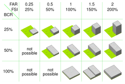
Clarifying Duany's second criticism in reference to "lot coverage": If localities seek to regulate density through floor area ratio, the logical consequence is to encourage expansive one story building with less green space, as single story construction is less expensive than multi-story construction on a per square foot basis. On the other hand, if density is regulated by building coverage ratio (a.k.a. lot coverage or site coverage [14] ) then green space can be preserved and multi-story construction becomes financial advantageous. This outcome is demonstrated in the illustration comparing FAR to BCR.
In urban planning, zoning is a method in which a municipality or other tier of government divides land into "zones", each of which has a set of regulations for new development that differs from other zones. Zones may be defined for a single use, they may combine several compatible activities by use, or in the case of form-based zoning, the differing regulations may govern the density, size and shape of allowed buildings whatever their use. The planning rules for each zone determine whether planning permission for a given development may be granted. Zoning may specify a variety of outright and conditional uses of land. It may indicate the size and dimensions of lots that land may be subdivided into, or the form and scale of buildings. These guidelines are set in order to guide urban growth and development.
Growth management, in the United States, is a set of techniques used by the government to ensure that as the population grows that there are services available to meet their demands. Growth management goes beyond traditional land use planning, zoning and subdivision controls in both the characteristics of development influenced and the scope of government powers used. These are not necessarily only government services. Other demands such as the protection of natural spaces, sufficient and affordable housing, delivery of utilities, preservation of buildings and places of historical value, and sufficient places for the conduct of business are also considered.
Downtown is a term primarily used in North America to refer to a city's sometimes commercial, cultural and often the historical, political, and geographic heart. It is often synonymous with its central business district (CBD). It may also be a center for shopping and entertainment. Downtowns typically contain a small percentage of a city's employment but are concentrated in services, including high-end services. Sometimes, smaller downtowns include lower population densities and nearby lower incomes than suburbs. It is often distinguished as a hub of public transit and culture.
A variance is a deviation from the set of rules a municipality applies to land use and land development, typically a zoning ordinance, building code or municipal code. The manner in which variances are employed can differ greatly depending on the municipality. A variance may also be known as a standards variance, referring to the development standards contained in code. A variance is often granted by a Board or Committee of adjustment.
A setback, in the specific sense of a step-back, is a step-like form of a wall or other building frontage, also termed a recession or recessed story. Importantly, one or more step-backs lowers the building's center of mass, making it more stable. A setback as a minimum one-bay indent across all stories is called a recessed bay or recess and is the more common exterior form of an alcove.
In land use, a setback is the minimum distance which a building or other structure must be set back from a street or road, a river or other stream, a shore or flood plain, or any other place which is deemed to need protection. Depending on the jurisdiction, other things like fences, landscaping, septic tanks, and various potential hazards or nuisances might be regulated and prohibited by setback lines. Setbacks along state, provincial, or federal highways may also be set in the laws of the state or province, or the federal government.
A Form-Based Code (FBC) is a means of regulating land development to achieve a specific urban form. Form-Based Codes foster predictable built results and a high-quality public realm by using physical form as the organizing principle, with less focus on land use, through municipal regulations. An FBC is a regulation, not a mere guideline, adopted into city, town, or county law and offers a powerful alternative to conventional zoning regulation.
Height restriction laws are laws that restrict the maximum height of structures. There are a variety of reasons for these measures. Some restrictions serve aesthetic values, such as blending in with other housing and not obscuring important landmarks. Other restrictions may serve a practical purpose, such as height restrictions around airports for flight safety. Height restriction laws for housing have become a source of contention by restricting housing supply, increasing housing costs, and depressing land values.
SmartCode is a unified land development ordinance template for planning and urban design. Originally developed by Duany Plater-Zyberk & Company, this open source program is a model form-based unified land development ordinance designed to create walkable neighborhoods across the full spectrum of human settlement, from the most rural to the most urban, incorporating a transect of character and intensity within each. It folds zoning, subdivision regulations, urban design, and basic architectural standards into one compact document. Because the SmartCode enables community vision by coding specific outcomes that are desired in particular places, it is meant to be locally calibrated by professional planners, architects, and attorneys.
In real estate, a land lot or plot of land is a tract or parcel of land owned or meant to be owned by some owner(s). A plot is essentially considered a parcel of real property in some countries or immovable property in other countries. Possible owners of a plot can be one or more persons or another legal entity, such as a company, corporation, organization, government, or trust. A common form of ownership of a plot is called fee simple in some countries.
Build-out is an urban planner’s estimate of the amount and location of potential development for an area. Sometimes called a "lot-yield analysis", build-out is one step of the land use planning process. Evaluation of potential development impacts begins with a build-out analysis.
The 1916 Zoning Resolution in New York City was the first citywide zoning code in the United States. The zoning resolution reflected both borough and local interests, and was adopted primarily to stop massive buildings from preventing light and air from reaching the streets below. It also established limits in building massing at certain heights, usually interpreted as a series of setbacks and, while not imposing height limits, restricted towers to 25% of the lot size. The chief authors of this resolution were George McAneny and Edward M. Bassett.
SouthField is a form-based code planned community located on the former South Weymouth Naval Air Station in South Weymouth, Massachusetts. It is a 1,400-acre (6 km2) site 12 miles (19 km) south of Boston that overlaps three towns: Weymouth, Abington, and Rockland. Developed by LNR Property Corporation, SouthField will contain 2,855 housing units and up to 2,000,000 square feet (186,000 m2) that include single-family homes, apartments, and townhouses. The site will also have up to 1.7 million square feet of commercial development, a 45-acre recreational facility, an 18-hole golf course, walking trails and 1,000 acres of undeveloped land.
Zoning is a law that divides a jurisdiction's land into districts, or zones, and limits how land in each district can be used. In the United States, zoning includes various land use laws enforced through the police power rights of state governments and local governments to exercise authority over privately owned real property.
Robert Michael Scarano Jr. is an American architect who works primarily in Brooklyn, New York City. In March 2010, Scarano was barred from submitting plans for new buildings to New York City's Department of Buildings.
A residential cluster development, or open space development, is the grouping of residential properties on a development site to use the extra land as open space, recreation or agriculture. It is increasingly becoming popular in subdivision development because it allows the developer to spend much less on land and obtain much the same price per unit as for detached houses. The shared garden areas can be a source of conflict, however. Claimed advantages include more green/public space, closer community, and an optimal storm water management. Cluster development often encounters planning objections.
Exclusionary zoning is the use of zoning ordinances to exclude certain types of land uses from a given community, especially to regulate racial and economic diversity. In the United States, exclusionary zoning ordinances are standard in almost all communities. Exclusionary zoning was introduced in the early 1900s, typically to prevent racial and ethnic minorities from moving into middle- and upper-class neighborhoods. Municipalities use zoning to limit population density, such as by prohibiting multi-family residential dwellings or setting minimum lot size requirements. These ordinances raise costs, making it less likely that lower-income groups will move in. Development fees for variance, a building permit, a certificate of occupancy, a filing (legal) cost, special permits and planned-unit development applications for new housing also raise prices to levels inaccessible for lower income people.
A pencil tower is a high-rise building or skyscraper with a very high slenderness ratio that is very tall and thin. There is no universal definition of how slender these buildings are to be categorized, but some definitions of 10:1 or 12:1 ratios and higher have been used.
In architecture, construction, and real estate, floor area, floor space, or floorspace is the area taken up by a building or part of it. The ways of defining "floor area" depend on what factors of the building should or should not be included, such as external walls, internal walls, corridors, lift shafts, stairs, etc. Generally there are three major differences in measuring floor area.
Missing middle housing refers to a lack of medium-density housing in the North American context. The term describes an urban planning phenomenon in Canada, the United States, Australia and more recent developments in industrialized and newly industrializing countries due to zoning regulations favoring social and racial separation and car-dependent suburban sprawl.