Sud-Est is one of the ten departments of Haiti. It has an area of 2,034.10 km² and a population of 632,601 (2015). Its capital is Jacmel.

Jaala is a former municipality of Finland.
Grand Lake can refer to at least 9 different lakes in the Canadian province of Nova Scotia:
Johnstone Creek Provincial Park is a provincial park in British Columbia, Canada, located west of the confluence of Rock Creek and the Kettle River and the town of Rock Creek. The park has roughly 38ha area, and is fairly near to the Crowsnest Highway.
Mehatl Creek Provincial Park is a provincial park in British Columbia, Canada, located in the central Lillooet Ranges to the west of Boston Bar.
Moose Valley Provincial Park is a provincial park in British Columbia, Canada, located in the South Cariboo region 31 km west of 100 Mile House.
Upper Violet Creek Provincial Park is a provincial park in British Columbia, Canada.
Stuart River Provincial Park is a provincial park in British Columbia, Canada. It is located in two sections north and northwest of Vanderhoofalong the Stuart River southeast of Stuart Lake and the city of Fort St. James. The upper section is located at 54°13′20″N124°00′00″W and comprises c.7391 ha. while the lower, eastern section is centred at 54°03′00″N123°37′00″W and comprises c.3390 ha. and is within the Greater Prince George area. The upper site, which is located around the confluence of the Stuart and Nechako Rivers, includes the site of Chinlac, a Dakelh village whose inhabitants were massacred and enslaved by the Tsilhqot'in of Anahim Lake c. 1745.
Tsintsunko Lakes Provincial Park is a provincial park in British Columbia, Canada. It is located south of the Deadman River between Kamloops (SE) and Bonaparte Lake (NW).
Paltas is located to the south of Loja city and is one of the oldest cantons of province of the same name. It was named after the Paltas, community who used to live over the new city now called Catacocha in Ecuador.

The Gwa'Sala-Nakwaxda'xw Nations are a union of two Kwakwaka'wakw peoples in a band government based on northern Vancouver Island in British Columbia, Canada, whose main reserve community is near the town of Port Hardy in the Queen Charlotte Strait region of the Central Coast region of British Columbia, Canada. The band government is a member of the Kwakiutl District Council and, for treaty negotiation purposes, the Winalagalis Treaty Group which includes three other members of the Kwakiutl District Council.
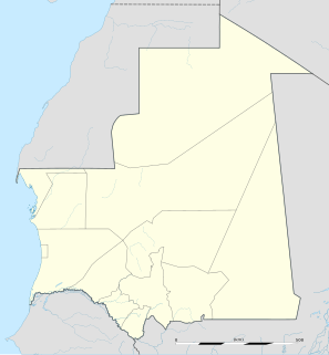
Mederdra is a small town and commune in south-west Mauritania. In 2000 it had a population of 6,858.

Wagners is a former settlement in Butte County, California. It was located 9 miles (14 km) north-northwest of Clipper Mills, at an elevation of 4101 feet. It appears on maps as of 1897.
The Sentinel Range is one of the northernmost sub-ranges of the Canadian Rockies, lying between Muncho Lake (SW) and the Liard River (N). The northernmost is the Terminal Range, so named for its position at the terminus of the Rockies, and lies to its west.
Camizunzo is a small town to the east of the capital of Angola, Luanda, in Bengo Province.
Ffryes is a town in Saint Philip Parish, located on northeastern Antigua island in Antigua and Barbuda.
The Leq' a: mel First Nation, formerly known as the Lakahahmen First Nation, is a First Nations band government whose community and offices are located in the area near Deroche, British Columbia, Canada, about 12 kilometres east of the District of Mission. They are a member government of the Sto:lo Nation tribal council, which is one of two tribal councils of the Sto:lo.

Fern Ridge is a neighbourhood of Langley, British Columbia. It is located in the southwestern area of Langley Township, near Campbell Valley Park. 200th Street, or Carvolth Road, runs south through Fern Ridge, and TransLink provides hourly bus service during daylight hours to Langley City. There is one church in the community, a Mennonite church.

Burdenis Glacier is the 6 km long and 1.7 km wide glacier on the east side of the main crest of north-central Sentinel Range in Ellsworth Mountains, Antarctica. It is situated north of Delyo Glacier and south of Gerila Glacier. The glacier drains the north slopes of Mount Viets and the southeast slopes of the southern summit of Long Gables Peak, flows northeastwards and together with Delyo Glacier and Gerila Glacier joins upper Ellen Glacier north of Bruguière Peak.