Related Research Articles
The ceremonial county of Lincolnshire is the second largest of the English counties and one that is predominantly agricultural in character. Despite its relatively large physical area, it has a comparatively small population. The unusually low population density that arises gives the county a very different character from the much more densely populated an urbanised counties of south-east and northern England, and is, in many ways, key to understanding the nature of the county.
Aby with Greenfield is a civil parish in the East Lindsey district of Lincolnshire, England. The population of the civil parish at the 2011 Census was 196. It consists of the villages of Aby and Greenfield. The parish is situated approximately 7 miles (11 km) south-east from Louth.

Beesby with Saleby is a civil parish in the East Lindsey district of Lincolnshire, England. It includes Beesby and Saleby. According to the 2001 Census it had a population of 228, increasing to 258 at the 2011 Census.
Brackenborough with Little Grimsby is a civil parish in the East Lindsey district of Lincolnshire, England.

Spilsby was a rural district in Lincolnshire, parts of Lindsey from 1894 to 1974.
Aby for Claythorpe was a railway station on the East Lincolnshire Railway which served the hamlets of Aby and Claythorpe in Lincolnshire between 1848 and 1961. It originally opened as Claythorpe, but was renamed in 1885. Withdrawal of goods facilities took place in 1961, on the same day that the station was closed to passengers. The line through the station is closed.

Sibsey was a railway station on the East Lincolnshire Railway which served the village of Sibsey in Lincolnshire between 1848 and 1964. Withdrawal of passenger services took place in 1961, followed by goods facilities in 1964. The line through the station remains in use as part of the Poacher Line between Boston and Skegness.

East Ville was a railway station on the East Lincolnshire Railway which served the village of Eastville in Lincolnshire between 1848 and 1964. It originally opened as East Ville and New Leake, but was renamed in 1850. Withdrawal of passenger services took place in 1961, followed by goods facilities in 1964. The line through the station remains in use as the Poacher Line

Burgh-le-Marsh was a railway station on the East Lincolnshire Railway which served the village of Burgh le Marsh in Lincolnshire between 1848 and 1970. It originally opened as Burgh, but was renamed in 1923. Withdrawal of goods facilities took place in 1966, followed by passenger services in 1970. The line through the station is now closed.

Willoughby was a railway station on the East Lincolnshire Railway which served the village of Willoughby in Lincolnshire between 1848 and 1970. In 1886, a second larger station replaced the first following the opening of a junction with the Mablethorpe Loop Line to Sutton-on-Sea and later Mablethorpe. The withdrawal of goods facilities at Willoughby took place in 1966, followed by passenger services in 1970. All lines through the station are now closed.

Alford Town was a railway station on the East Lincolnshire Railway which served the town of Alford in Lincolnshire between 1848 and 1970. It originally opened as Alford, but was renamed in 1923. When passenger services were withdrawn in 1970 the line through the station was closed.

Authorpe was a railway station on the East Lincolnshire Railway, which served the village of Authorpe in Lincolnshire between 1848 and 1964. The station was closed to passengers in 1961, and withdrawal of goods facilities took place in 1964. The line through the station is closed.
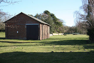
Legbourne Road was a railway station on the East Lincolnshire Railway which served the village of Legbourne in Lincolnshire between 1848 and 1964. The station was closed to passengers in 1953, and withdrawal of goods facilities took place in 1964. The line through the station closed in 1970. The station once housed a museum containing railway memorabilia; this closed in 1998 and the building is once again a private residence.

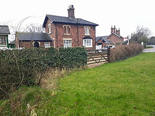
Saltfleetby railway station was a station in Saltfleetby, Lincolnshire on the line between Louth and Mablethorpe which was closed in 1960.

Ulceby with Fordington is a civil parish in the East Lindsey district of Lincolnshire, England. The parish is situated 27 miles (43 km) east from the city and county town of Lincoln and 3 miles (5 km) south-west from Alford. The A1028 road runs through the parish.
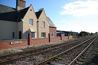
Snelland railway station was a station in Snelland, Lincolnshire, opened in 1848 as part of the Sheffield and Lincolnshire Extension Railway. and closed in 1965.

Haxey and Epworth railway station was located near Haxey, Lincolnshire, England. It closed to passengers in 1959 and completely in 1964.
Fordington may refer to:
Legbourne Priory was a priory in the village of Legbourne, Lincolnshire, England.
The south bank of the Humber Estuary in England is a relatively unpopulated area containing large scale industrial development built from the 1950s onward, including national scale petroleum and chemical plants as well as gigawatt scale gas fired power stations.
References
- Cox, John Charles. Lincolnshire: Little guides. Methuen, 1924.
Coordinates: 53°13′23″N0°07′23″E / 53.223°N 0.123°E
| This Lincolnshire location article is a stub. You can help Wikipedia by expanding it. |