
The Isle of Wight is a county and the largest and second-most populous island in England. It is in the English Channel, between 2 and 5 miles off the coast of Hampshire, separated by the Solent. The island has resorts that have been holiday destinations since Victorian times, and is known for its mild climate, coastal scenery, and verdant landscape of fields, downland and chines. The island is designated a UNESCO Biosphere Reserve.
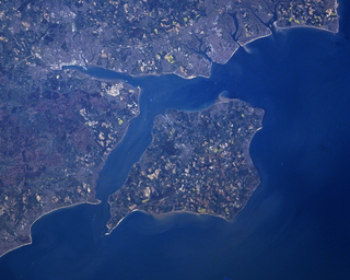
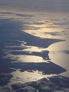
The Solent is the strait that separates the Isle of Wight from the mainland of England. It is about 20 miles long and varies in width between 2 1⁄2 and 5 mi, although the Hurst Spit which projects 1 1⁄2 mi (2.4 km) into the Solent narrows the sea crossing between Hurst Castle and Colwell Bay to just over 1 mi (1.6 km).

Alum Bay is a bay near the westernmost point of the Isle of Wight, England, within close sight of the Needles rock formation. Of geological interest and a tourist attraction, the bay is noted for its multi-coloured sand cliffs. The waters and adjoining seabed form part of the Needles Marine Conservation Zone and the shore and heath above are part of the Headon Warren and West High Down Site of Special Scientific Interest.
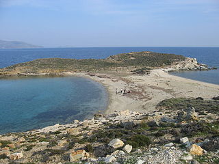
A tombolo, from the Italian tombolo, derived from the Latin tumulus, meaning 'mound', and sometimes translated as ayre, is a deposition landform in which an island is attached to the mainland by a narrow piece of land such as a spit or bar. Once attached, the island is then known as a tied island. A tombolo is a sandy isthmus.
Ballard Down is an area of chalk downland on the Purbeck Hills in the English county of Dorset. The hills meet the English Channel here, and Ballard Down forms a headland, Ballard Point, between Studland Bay to the north and Swanage Bay to the south. The chalk here forms part of a system of chalk downlands in southern England, and once formed a continuous ridge between what is now west Dorset and the present day Isle of Wight. Old Harry Rocks, just offshore from the dip slope of the down, and The Needles on the westernmost tip of the Isle of Wight, are remnants of this ridge. The scarp slope of the down faces south, over Swanage, meeting the sea as Ballard Cliff.

A promontory fort is a defensive structure located above a steep cliff, often only connected to the mainland by a small neck of land, thus using the topography to reduce the ramparts needed. Although their dating is problematic, most seem to date to the Iron Age. They are mainly found in Brittany, Ireland, the Orkney Islands, the Isle of Man, Devon and Cornwall.

In geography, a cape is a headland or a promontory of large size extending into a body of water, usually the sea. A cape usually represents a marked change in trend of the coastline which makes them prone to natural forms of erosion, mainly tidal actions. This results in capes having a relatively short geological lifespan. Capes can be formed by glaciers, volcanoes, and changes in sea level. Erosion plays a large role in each of these methods of formation.
Pentire Head is a headland and peninsula on the Atlantic coast in North Cornwall, England, and is about one mile square. The headland projects north-west with Pentire Point at its north-west corner and The Rumps promontory at its north-east corner.

Lützow-Holm Bay is a large bay, about 220 kilometres (120 nmi) wide, indenting the coast of Queen Maud Land in Antarctica between Riiser-Larsen Peninsula and the coastal angle immediately east of the Flatvaer Islands. It was discovered by Captain Hjalmar Riiser-Larsen in two airplane flights from his expedition vessel, the Norvegia, on February 21 and 23, 1931. The name honours Commander Finn Lützow-Holm of the Royal Norwegian Navy Air Service, a pilot for Captain Riiser-Larsen on the Aagaard in 1935.

Sandown Bay is a broad open bay which stretches for much of the length of the Isle of Wight's southeastern coast. It extends 8 1⁄2 miles (13.7 km) from Culver Down, near Yaverland in the northeast of the Island, to just south of Shanklin, near the village of Luccombe in the southwest. At Luccombe, the bay is separated from The Undercliff by a large headland from which Upper Ventnor sits atop. The towns of Shanklin, Lake and Sandown are on the bay's coast, while Luccombe and Upper Ventnor feature panoramic views across both Sandown Bay to the East and the Undercliff to the southwest. Due to the bay being relatively sheltered from offshore winds it is often used as temporary anchorage point for boats, including large cargo ships, before continuing east towards Continental Europe, or north towards The Solent.

Foreland or Forelands, and the adjacent Foreland Fields, is the easternmost point of the Isle of Wight, part of the village of Bembridge. It is located about 6.5 miles due south of the city of Portsmouth on the British mainland, separated by the eastern reaches of the Solent. It is characterised by a pub called the Crab and Lobster Inn and various beach huts plus a beach cafe and a coast guard lookout. In the sea are the reefs of Bembridge Ledge which is rich in edible crabs, lobsters and spider crabs and shoals of mackerel. In the Crab & Lobster Inn are photographs of the many shipwrecks, which included the submarine HMS Alliance, now a museum ship at Gosport and the First World War troopship the S.S. Mehndi carrying troops from South Africa, with great loss of life.
Selsey Bill is a headland into the English Channel on the south coast of England in the county of West Sussex.

Chillerton is a village between Newport and Chale in the Isle of Wight in southern England. Chillerton is in the middle of a farming community. The appropriate civil parish is called Chillerton and Gatcombe.

Foreland Point is a rocky headland in Devon near Lynmouth, and is the most northerly point along the Devon and Exmoor coast. The highest cliff is 89 metres (292 ft) above the high tide, although the highest point of the entire headland is near Countisbury at 302 metres (991 ft). The headland is owned by the National Trust; some areas are open to public access all year, as part of the South West Coast Path, while other areas have limited access. The Trinity House-operated Lynmouth Foreland Lighthouse is also located here.

Possession Bay is a bay 2 miles (3.2 km) wide on the north coast of South Georgia, an island in the southern Atlantic Ocean. It recedes southwest for 5 miles (8 km), and is separated from Cook Bay to the north by Black Head promontory. It is connected to King Haakon Bay by Shackleton Gap, a mountain pass.
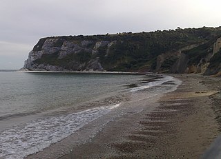
Whitecliff Bay is a sandy bay near Foreland which is the easternmost point of the Isle of Wight, England, about two miles south-west of Bembridge and just to the north of Culver Down. The bay has a shoreline of around three-quarters of a mile (1.2 km) and has a popular sandy shingle beach which is over half a mile long. It is a tourist site with three holiday parks in the vicinity of the bay; it has two cafes though minimal facilities. Access is limited and only possible down two steeply sloping concrete tracks.

Horseshoe Bay is a small bay on the south-east coast of the Isle of Wight, England. It lies at the east end of the headland of Culver Down. It faces south-east towards the English Channel and its shoreline is approximately 100 yards (90 m) in length. It should not be confused with a similarly named Horseshoe Bay about 8 miles (13 km) southwest at Bonchurch.

North Foreland is an ice-free headland on the northern coast of King George Island, the largest of the South Shetland Islands of Antarctica. It lies at the eastern entrance to Emerald Cove, 4.5 km east of Milosz Point, extending northwards for about 2 km and forming the northernmost extremity of the Island.

The Ness of Burgi fort is an iron-age promontory fort on the Ness of Burgi, a narrow finger of land reaching south from the Scat Ness in the far south of the island of Mainland, Shetland in Scotland.