La Défense is a major business district located three kilometres west of the city limits of Paris. It is part of the Paris Metropolitan Area in the Île-de-France region, located in the department of Hauts-de-Seine in the communes of Courbevoie, Nanterre, and Puteaux.

The Roman Catholic Archdiocese of Besançon is a Latin Rite Roman Catholic ecclesiastical territory in France. It comprises the département of Doubs and the département of Haute-Saône, except for the canton of Héricourt.

The arrondissement of Besançon is an arrondissement of France in the Doubs department in the Bourgogne-Franche-Comté region. In 2009 the two cantons of Pierrefontaine-les-Varans and Vercel that previously belonged to the arrondissement of Besançon were added to the arrondissement of Pontarlier. It has 256 communes.

The Vallée Blanche Cable Car, , is a passenger cable car linking a mountain peak above Courmayeur (Italy) to a peak above Chamonix (France) by passing over the Mont Blanc massif, in the Alps. The engineering was developed by Vittorio Zignoli of Polytechnic University of Turin. No helicopters were used, and all the workers were chosen among locals and alpine guides. After a construction period of four years, it began service in 1958.
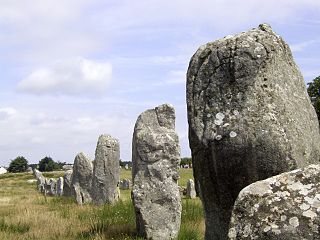
The Carnac stones are an exceptionally dense collection of megalithic sites around the village of Carnac in Brittany, consisting of alignments, dolmens, tumuli and single menhirs. More than 3,000 prehistoric standing stones were hewn from local rock and erected by the pre-Celtic people of Brittany, and form the largest such collection in the world. Most of the stones are within the Breton village of Carnac, but some to the east are within La Trinité-sur-Mer. The stones were erected at some stage during the Neolithic period, probably around 3300 BCE, but some may date to as early as 4500 BCE.
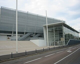
Palais des Sports is an indoor sports arena, located in Besançon, France. The capacity of the arena is 4,000 people.

The A36 autoroute is a toll motorway in northeastern France connecting the German border with Burgundy. It is also known as La Comtoise. The road forms part of European route E60.

Battant is one of the oldest parts of Besançon, Doubs, France, and has been under architectural protection since 1964. It is situated on the right bank of the river Doubs, north of the ox-bow that encircles the center of the city. A bridge across the Doubs joins the two quarters Battant and La Boucle, via the Vauban quay and Jouffroy d'Abbans Place.
Bregille is a district of the French city of Besançon, located on the right bank of the Doubs, south-east of the historic center. It has developed on the eponymous hill Bregille which culminates at 458 meters, almost 200 meters above the river level. It has about 6 500 inhabitants in the early 2000s

Montrapon, with Fontaine-Écu are two sectors forming an area located in the north of Besançon (France). In 1990, they counted approximately 10,000 inhabitants.

The fort of Planoise is a fortification located on the summit of the hill of Planoise, in Besançon. Although its location was extremely strategic, the fort was not used during the first nor second World War.

Fort de Villey-le-Sec, also known as Fort Trévise, is a fortification of the 19th century, built as part of the Séré de Rivières system of fortifications in Villey-le-Sec, France, one of the defenses of Toul. It is a unique example for its time of a defensive enclosure around a village. Conceived after the defeat of the Franco-Prussian War of 1870-71, the fort was located away from the main combat zone of World War I and has remained almost intact. The fort's preservation association has been at work since 1961 to restore and interpret the site. It has been included in the Inventory of Historic Sites and has been designated as a preserved natural area.

Fort du Mont Bart is located to the south of Montbéliard, France. It was built between November 1874 and July 1877 as part of the Séré de Rivières system of fortifications. The fort overlooks the valleys of the Doubs and the Allan at an elevation of 497 metres (1,631 ft), standing to the south and rear of the fortified region of Belfort and in control of the road to Besançon. The fort was intended to augment the Belfort fortifications and to prevent an enemy from bypassing them. The most striking feature of the Fort du Mont Bart is its "interior street", originally constructed in the open air as a sunken court, then covered before World War I with reinforced concrete.

Bibliothèque municipale de Besançon is the most important library in Besançon, but also the first French building which was constructed to be the public library.
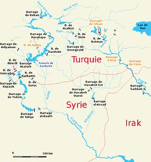
The Sājūr River is a 108 kilometres (67 mi) long river originating in Turkey and flowing into the Euphrates in Syria. It is the smallest of the three rivers joining the Euphrates in Syria, and the only one that joins the Euphrates on its right bank. Occupation in the Sājūr basin started in the Lower Palaeolithic period and continues until today.
The Fort de Fléron is one of twelve forts built as part of the Fortifications of Liège in the late 19th century in Belgium. It was built between 1881 and 1891 according to the plans of General Henri Alexis Brialmont. Contrasting with the French forts built in the same era by Raymond Adolphe Séré de Rivières, the fort was built exclusively of unreinforced concrete, a new material, rather than masonry. The fort was heavily bombarded by German artillery in the Battle of Liège. Fléron was upgraded in the 1930s to become part of the fortified position of Liège in an attempt to forestall or slow an attack from Germany. Located in the center of Fléron, the fort has been buried and is surrounded by apartments.

The Fort de Barchon is one of twelve forts built as part of the Fortifications of Liège in the late 19th century in Belgium. It was built between 1881 and 1884 according to the plans of General Henri Alexis Brialmont. Contrasting with the French forts built in the same era by Raymond Adolphe Séré de Rivières, the fort was built exclusively of unreinforced concrete, a new material, rather than masonry. The fort was heavily bombarded by German artillery in the Battle of Liège. Barchon was upgraded in the 1930s to become part of the fortified position of Liège in an attempt to forestall or slow an attack from Germany. It saw action in 1940 during the Battle of Belgium, and was captured by German forces. It is preserved as a museum and may be visited by the public.

Tell Zeitoun also called Tell Dnaibe, is an arcaheological site 8 kilometres (5.0 mi) southwest of Rashaya in Lebanon at an altitude of 900 metres (3,000 ft).

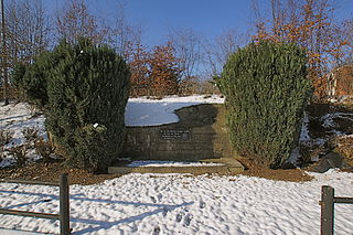
The Fort of Justices was built in the 1860s or early 1870s located in Montrapon-Fontaine-Écu, Besançon, Franche-Comté. It was constructed for use in the Franco-Prussian War to stop the Prussian forces from invading from Vesoul, but was never used in battle and was abandoned. It was later demolished in the 1980s.