The Frøya Tunnel is an undersea tunnel connecting the municipalities of Frøya and Hitra in Trøndelag county, Norway. The tunnel is located about 4 kilometres (2.5 mi) south of the village of Sistranda on Frøya.

Hestvika is a village in the municipality of Hitra in Trøndelag county, Norway. The village is located on the southeastern tip of the island of Hitra along the Trondheimsleia, about 6 kilometres (3.7 mi) east of the village of Sandstad and the entrance to the Hitra Tunnel. The 0.36-square-kilometre (89-acre) village has a population (2018) of 263 and a population density of 731 inhabitants per square kilometre (1,890/sq mi).
Mørkdalstuva or Mørkdalstua is the tallest mountain on the island of Hitra in the municipality of Hitra in Trøndelag county, Norway. The 345-metre (1,132 ft) tall mountain lies on the western side of the island, about 8 kilometres (5.0 mi) northeast of the village of Forsnes and 7.5 kilometres (4.7 mi) southeast of the village of Kvenvær.
Fillan is the administrative centre of Hitra municipality in Trøndelag county, Norway. The village is located on the northeastern side of the island of Hitra, about 5 kilometres (3.1 mi) south of the village of Ansnes. The island of Fjellværsøya lies about 3 kilometres (1.9 mi) to the northeast, across the Fillfjorden.

Sandstad is a village in Hitra municipality in Trøndelag county, Norway. The village is located along the Trondheimsleia on the southeastern coast of the island of Hitra, about 6 kilometres (3.7 mi) southwest of the village of Hestvika. The north entrance to the Hitra Tunnel lies just south of the village of Sandstad. The Terningen lighthouse lies in the Trondheimsleia, about 3 kilometres (1.9 mi) southwest of the village. In 2018, there were about 229 residents in the village. Sandstad Church is located here.

Hitra Wind Farm is a 24-turbine wind farm located in the municipality of Hitra in Trøndelag county, Norway and operated by Statkraft. The farm is located on top of the Elsfjellet plateau in the central part of the island of Hitra, just 3 kilometres (1.9 mi) south of the village of Straum and about 15 kilometres (9.3 mi) west of Sandstad. Until the expansion of the Smøla Wind Farm in 2005, Hitra was the largest wind farm in the country and had total cost of 450 million kr.
Ulvan is a village on the island of Ulvøya in the municipality of Hitra in Trøndelag county, Norway. It is located on the western side of the island, along the Frøyfjorden, about 2.5 kilometres (1.6 mi) west of the village of Knarrlaget. Ulvan is home to a large fish processing plant operated by Marine Harvest.
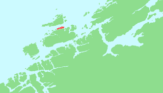
Hammarvika is a village in the municipality of Frøya in Trøndelag county, Norway. The village is located about 4 kilometres (2.5 mi) south of the municipal center of Sistranda on the southeastern side of the island of Frøya. The 0.58-square-kilometre (140-acre) village has a population (2018) of 461 and a population density of 795 inhabitants per square kilometre (2,060/sq mi).
Dolmøya is an island in the municipality of Hitra in Trøndelag county, Norway. The island is located in the Frøyfjorden, just north of the village of Melandsjøen on the island of Hitra. The island of Dolmøya is flat, swampy, and has very few trees. The 14.5-square-kilometre (5.6 sq mi) island is also the location of the southern entrance to the Frøya Tunnel. The medieval Dolm church is located on the southeastern shore of the island. There were about 488 residents living on the island in 2017.

Fjellværsøya is an island in the municipality of Hitra in Trøndelag county, Norway. The island is located in the eastern part of Hitra municipality, east of the main island of Hitra and it is surrounded by the Frøyfjorden, Kråkvågfjorden, and Fillfjorden.

Helgbustadøya is an island in the municipality of Hitra in Trøndelag county, Norway. It is an island located in the Straumsfjorden just off the northwestern coast of the island of Hitra, just east of the Bispøyan islands, about 10 kilometres (6.2 mi) northeast of the village of Kvenvær, and about 8 kilometres (5.0 mi) southwest of the village of Melandsjøen.
Ulvøya is an island in the municipality of Hitra in Trøndelag county, Norway. The 6.4-square-kilometre (1,600-acre) island is located just north of Fjellværsøya island. The Knarrlagsundet bridge connects the two islands. The island is home to the villages of Knarrlagsund and Ulvan. Marine Harvest has a fish processing plant in Ulvan. The large island of Hitra lies about 3 kilometres (1.9 mi) to the southwest.
Ansnes is a village in the municipality of Hitra in Trøndelag county, Norway. The village is located along the Fillfjorden on the northeastern coast of the island of Hitra. There is a bridge from Ansnes to the island of Fjellværsøya to the east. The village is located about 6 kilometres (3.7 mi) north of the municipal center of Fillan. The village has a fishing harbor and is home to many aspects of the fishing industry.
Knarrlagsund or Knarrlaget is a village on the island of Ulvøya in the municipality of Hitra in Trøndelag county, Norway. It is located on the southern part of the island about 2.5 kilometres (1.6 mi) east of the village of Ulvan.
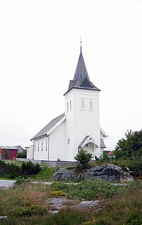
Kvenvær Church is a parish church in Hitra municipality in Trøndelag county, Norway. It is located in the village of Kvenvær on the northwestern coast of the island of Hitra. It is the main church for the Kvenvær parish which is part of the Orkdal prosti (deanery) in the Diocese of Nidaros. The white, wooden church was built in a long church style in 1909 by the architect Nils Ryjord. The church seats about 500 people.

Besselvassheia is a mountain in the municipality of Frøya in Trøndelag county, Norway. The 76-metre (249 ft) tall mountain is the highest point on the island of Frøya. It lies about 4 kilometres (2.5 mi) west of the village of Sistranda and about 4 kilometres (2.5 mi) northwest of the village of Hammarvika.

Hemnskjela is an island in the municipality of Snillfjord in Trøndelag county, Norway. The 4.4-square-kilometre (1.7 sq mi) island is located in the Trondheimsleia strait at the mouth of the Hemnfjorden, just 2 kilometres (1.2 mi) south of the village of Sandstad on the nearby island of Hitra.
Hitra is an island in Hitra municipality in Trøndelag county, Norway. The 571.5-square-kilometre (220.7 sq mi) island is the 7th largest island in Norway and it is the largest island south of the Lofoten archipelago. The island lies between the Trondheimsleia strait and the Frøyfjorden, just southwest of the entrance to the Trondheimsfjorden. Hitra is surrounded by many islands such as Smøla to the southwest; Bispøyan, Helgbustadøya, Dolmøya, and Frøya to the north; Ulvøya, Fjellværsøya, and Leksa to the east; and Hemnskjela and the mainland of Norway to the south. The 345-metre (1,132 ft) tall Mørkdalstuva is the highest point on the island.
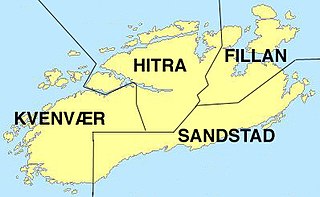
Kvenvær is a former municipality in the old Sør-Trøndelag county, Norway. The 216-square-kilometre (83 sq mi) municipality existed from 1913 until 1964. It is located in what is now the municipality of Hitra in Trøndelag county. The municipality included the western part of the island of Hitra plus many surrounding islands including Bispøyan. The administrative centre of the municipality was the village of Kvenvær where Kvenvær Church is located. Other villages in Kvenvær municipality included Forsnes and Andersskogan.


