This site was first fortified in 1736 by the Spanish, when they held colonies in Florida. From 1736, various nations to control the territory have garrisoned and fortified this site to protect the entrance to the St. Marys River and Cumberland Sound.
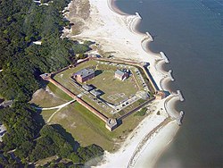
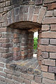
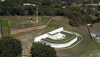
After the end of the Second Seminole War, the United States started construction of a fort, later named Fort Clinch, in 1847. It was part of its Third System of coastal defenses conceived earlier in the century, which guided fortifications throughout this period. The fortified compound is pentagonal in shape, with both inner and outer walls, and consists of almost five million bricks. There are corner bastions and embrasures in the outer walls and several structures in the interior courtyards, including a two-story barracks. The fort was named in honor of General Duncan Lamont Clinch after his death in 1849. General Clinch fought in the War of 1812 and was an important figure in the First and Second Seminole Wars.
Confederate forces seized the fort in early 1861. It was used as a safe haven for Confederate blockade runners during the first year of the Civil War. However, changes in technology, specifically the development of rifled cannon, had improved weaponry to the point that the fort's brick walls were vulnerable to attacks and thus obsolete. In March 1862 General Robert E. Lee ordered abandonment of the fort in order to use scarce troops in other areas. Afterwards Federal troops re-occupied the fort, taking control of the adjacent Georgia and Florida coasts. They used the fort as the base of Union operations in the area throughout the Civil War.
The fort was placed on caretaker status in 1869; it remained so until 1898, when the Army garrisoned it during the short Spanish–American War. In September of that year, the Army abandoned it again. The fort gradually deteriorated.[2]
During the Great Depression, workers of the Civilian Conservation Corps (CCC) began restoration of the fort during the 1930s. It was restored to the Civil War era.[3] In 1935, the State of Florida bought 256 acres (1.0km2) that included the then-abandoned fort and the surrounding area. Fort Clinch State Park including the fort, opened to the public in 1938.
The fort was closed to the public during World War II and used as a communications and security post. It was re-opened to public visits after the war ended.
The fort was placed on the National Register of Historic Places in 1972. It is interpreted largely in terms of its use as a base of Union operations during the American Civil War.[3] State Park personnel reenact military life at the fort, which is open from 8:00am until sundown, year-round.
Recreational Activities
Fort Clinch has a living history program. Visitors can interact with and learn from reenactors who dress in period-appropriate fashion and portray individuals who lived in the 1860s. On the first weekend of every month a soldier garrison fires cannons and demonstrates other battlefield skills.[4]
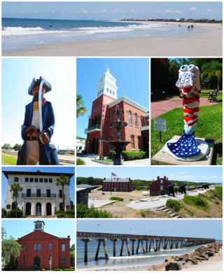
Fernandina Beach is a city in northeastern Florida and the county seat of Nassau County, Florida, United States. It is the northernmost city on Florida's Atlantic coast, situated on Amelia Island, and is one of the principal municipalities comprising Greater Jacksonville. The area was first inhabited by the Timucuan Indian people. Known as the "Isle of 8 Flags", Amelia Island has had the flags of the following nations flown over it: France, Spain, Great Britain, Spain (again), the Republic of East Florida (1812), the Republic of the Floridas (1817), Mexico, the Confederate States of America, and the United States.
Fort William and Mary was a colonial fortification in Britain's worldwide system of defenses, defended by soldiers of the Province of New Hampshire who reported directly to the royal governor. The fort, originally known as "The Castle," was situated on the island of New Castle, New Hampshire, at the mouth of the Piscataqua River estuary. It was renamed Fort William and Mary circa 1692, after the accession of the monarchs William III and Mary II to the British throne. It was captured by Patriot forces, recaptured, and later abandoned by the British in the Revolutionary War. The fort was renamed Fort Constitution in 1808 following rebuilding. The fort was further rebuilt and expanded through 1899 and served actively through World War II.
Fort Macon State Park is a North Carolina state park in Carteret County, North Carolina, in the United States. Located on Bogue Banks near Atlantic Beach, the park opened in 1936. Fort Macon State Park is the second most visited state park in North Carolina, with an annual visitation of 1.3 million, despite being one of the smallest state parks in North Carolina with 424 acres (1.72 km2). Fort Macon was built as part of the Third System of US fortifications, and was preceded by Fort Hampton of the Second System.
The Castillo de San Marcos is the oldest masonry fort in the continental United States; it is located on the western shore of Matanzas Bay in the city of St. Augustine, Florida.
Fort Moultrie is a series of fortifications on Sullivan's Island, South Carolina, built to protect the city of Charleston, South Carolina. The first fort, formerly named Fort Sullivan, built of palmetto logs, inspired the flag and nickname of South Carolina, as "The Palmetto State". The fort was renamed for the U.S. patriot commander in the Battle of Sullivan's Island, General William Moultrie. During British occupation, in 1780–1782, the fort was known as Fort Arbuthnot.
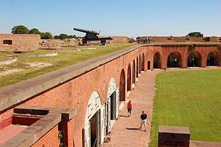
Fort Pulaski National Monument is located on Cockspur Island between Savannah and Tybee Island, Georgia. It preserves Fort Pulaski, the place where the Union Army successfully tested rifled cannon in combat during the American Civil War in 1862, the success of which rendered brick fortifications obsolete. The fort was also used as a prisoner-of-war camp.
San Marcos de Apalache Historic State Park is a Florida State Park in Wakulla County, Florida organized around the historic site of a Spanish colonial fort, which was used by succeeding nations that controlled the area. The Spanish first built wooden buildings and a stockade in the late 17th and early 18th centuries here, which were destroyed by a hurricane.
Fort Morgan is a historic masonry pentagonal bastion fort at the mouth of Mobile Bay, Alabama, United States. Named for American Revolutionary War hero Daniel Morgan, it was built on the site of the earlier Fort Bowyer, an earthen and stockade-type fortification involved in the final land battles of the War of 1812. Construction was completed in 1834, and it received its first garrison in March of the same year.
Fort Jay is a coastal bastion fort and the name of a former United States Army post on Governors Island in New York Harbor, within New York City. Fort Jay is the oldest existing defensive structure on the island, and was named for John Jay, a member of the Federalist Party, New York governor, Chief Justice of the United States, Secretary of State, and one of the Founding Fathers of the United States. It was built in 1794 to defend Upper New York Bay, but has served other purposes. From 1806 to 1904 it was named Fort Columbus, presumably for explorer Christopher Columbus. Today, the National Park Service administers Fort Jay and Castle Williams as the Governors Island National Monument.
Fort Barrancas (1839) or Fort San Carlos de Barrancas is a United States military fort and National Historic Landmark in the former Warrington area of Pensacola, Florida, located physically within Naval Air Station Pensacola, which was developed later around it.
The Fort Clinch State Park is a Florida State Park, located on a peninsula near the northernmost point of Amelia Island, along the Amelia River. Its 1,100 acres (4 km2) include the 19th-century Fort Clinch, sand dunes, plains, maritime hammock and estuarine tidal marsh. The park and fort lie to the northeast of Fernandina Beach at the entrance to the Cumberland Sound.
Fort Foster is a Second Seminole War era fort in central Florida, located 9 miles (14 km) south of current-day Zephyrhills in Pasco County.
Yellow Bluff Fort Historic State Park is a Florida State Park in Jacksonville, Florida. It is located near the mouth of the St. Johns River, a mile south of State Road 105 on New Berlin Road, in the cities Northside area. On September 29, 1970, it was added to the U.S. National Register of Historic Places.
Fort Harker, located near Stevenson, Alabama, was a military fortification built by the Union Army during the American Civil War. Constructed in the summer of 1862 by soldiers and freed slaves of the Army of the Cumberland, the fort helped secure strategic railroad lines to ensure the free movement of Union troops and supplies in southeastern Tennessee and northeastern Alabama. Union General William Rosecrans established his headquarters at Fort Harker in July, 1863, from where he directed a successful campaign against the position of Confederate General Braxton Bragg in Chattanooga, Tennessee. The fort would be abandoned after the war and fall into disrepair. After restoration, the site became a city park in 1985.
Columbus-Belmont State Park, on the shores of the Mississippi River in Hickman County, near Columbus, Kentucky, is the site of a Confederate fortification built during the American Civil War. The site was considered by both North and South to be strategically significant in gaining and keeping control of the Mississippi River. It commemorates military actions in Columbus, Kentucky, and across the river in Belmont, Missouri. This is 1 of 3 state parks in Kentucky that will be in the path of totality for the April 8, 2024, total solar eclipse.
Fort Sewall is a historic coastal fortification in Marblehead, Massachusetts. It is located at Gale's Head, the northeastern point of the main Marblehead peninsula, on a promontory that overlooks the entrance to Marblehead Harbor. Until 1814 it was called Gale's Head Fort.
Fort Davidson, a fortification near the town of Pilot Knob, Missouri, was the site of the Battle of Fort Davidson during the American Civil War. Built by Union Army soldiers during the American Civil War, the fort repulsed Confederate attacks during the Battle of Fort Davidson on September 27, 1864, during Price's Raid. That night, the Union garrison blew up the fort's magazine and abandoned the site. A mass grave was constructed on the site to bury battlefield dead. After the war, the area was used by a mining company, before passing into private hands and eventually the administration of the United States Forest Service. In 1968, the Battle of Pilot Knob State Historic Site was created as a Missouri State Park. The fort itself was added to the National Register of Historic Places in 1970. As of 2020, a visitors center containing a museum is located within the park. The museum contains a fiber optic display, as well as artifacts including Brigadier General Thomas Ewing Jr.'s sword. The fort's walls are still visible, as is the crater created when the magazine was detonated. A monument marks the location of the mass grave.
Fort Pemberton was one of the larger confederate forts was constructed in the defense of Charleston, South Carolina during the American Civil War. At the war's outset in 1861, it became evident that control of the western regions of James Island and the Stono River was to be an important element in the defense of the city. Confederate military authorities of the time believed that Union occupation of James Island would leave Charleston subject to attack from the southeast. From this position the city would assuredly fall to the Union. Although there were many gun batteries in place along the south and east side of James Island, Fort Pemberton was the only fortress in defense of this region.
Fort Norfolk is a historic fort and national historic district located at Norfolk, Virginia. With the original buildings having been built between 1795 and 1809, the fort encloses 11 buildings: main gate, guardhouse, officers' quarters, powder magazine, and carpenter's shop. Fort Norfolk is the last remaining fortification of President George Washington's 18th century harbor defenses, later termed the first system of US fortifications. It has served as the district office for the U.S. Army Engineer District, Norfolk since 1923.
This page is based on this Wikipedia article Text is available under the CC BY-SA 4.0 license; additional terms may apply. Images, videos and audio are available under their respective licenses.