Related Research Articles

The Potomac River is found within the Mid-Atlantic region of the United States and flows from the Potomac Highlands into the Chesapeake Bay. The river is approximately 405 miles (652 km) long, with a drainage area of about 14,700 square miles (38,000 km2). In terms of area, this makes the Potomac River the fourth largest river along the Atlantic coast of the United States and the 21st largest in the United States. Over 5 million people live within the Potomac watershed.

Hampshire County is a county in the U.S. state of West Virginia. As of the 2010 census, the population was 23,964. Its county seat is Romney, West Virginia's oldest town (1762). The county was created by the Virginia General Assembly in 1754, from parts of Frederick and Augusta Counties (Virginia) and is the state's oldest county. The county lies in both West Virginia's Eastern Panhandle and Potomac Highlands regions.

Wardensville is a town in Hardy County, West Virginia, United States. The population was 271 at the 2010 census. Originally named Trout Run, Wardensville was chartered in Virginia in 1832 and incorporated in West Virginia in 1879. Wardensville is located west of the Great North Mountain range, which separates it from the Shenandoah Valley. The town lies on the east bank of the Cacapon River at its confluence with Trout Run. The George Washington and Jefferson National Forests border the town to its east and south.
Thomas Fairfax, 6th Lord Fairfax of Cameron was a Scottish peer. He was the son of Thomas Fairfax, 5th Lord Fairfax of Cameron and of Catherine, daughter of Thomas Colepeper, 2nd Baron Colepeper.

Little Cacapon is an unincorporated community in Hampshire County in the U.S. state of West Virginia. Little Cacapon is located at the mouth of the Little Cacapon River on the Potomac, east of Okonoko. Okonoko-Little Cacapon Road and Spring Gap-Neals Run Road converge south of Little Cacapon. Because of its key location at the mouth of the Little Cacapon and on the Baltimore and Ohio Railroad, Little Cacapon played important roles in both the French and Indian and American Civil Wars. Generally pronounced kə-KAY-pən. Sometimes, despite the current spelling of the word some locals say KAY-pən.

Fairfax Stone Historical Monument State Park is a West Virginia state park commemorating the Fairfax Stone, a surveyor's marker and boundary stone at the source of the North Branch of the Potomac River. The original stone was placed on October 23, 1746 to settle a boundary dispute between Thomas Fairfax, 6th Lord Fairfax of Cameron and the English Privy Council concerning the Northern Neck of Virginia. It determined the proprietorship and boundaries of a large tract of mostly unsurveyed land in the English colonies of Maryland and Virginia.
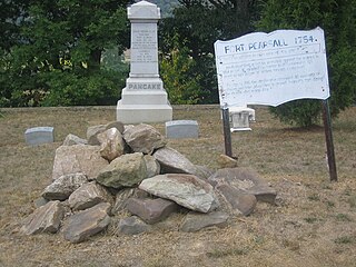
Fort Pearsall was an early frontier fort constructed in 1756 in Romney, West Virginia to protect local settlers in the South Branch Potomac River valley against Native American raids. The area around present-day Romney had been settled as early as 1725 by hunters and traders in the valley.

Capon Chapel, also historically known as Capon Baptist Chapel and Capon Chapel Church, is a mid-19th century United Methodist church located near to the town of Capon Bridge, West Virginia, in the United States. Capon Chapel is one of the oldest existing log churches in Hampshire County, along with Mount Bethel Church and Old Pine Church.
Fort Capon or Fort Enoch was a stockade fort erected in 1756 by the Virginia colonial militia located at the confluence of the North River and the Cacapon near present-day Forks of Cacapon in Hampshire County, West Virginia. The site of Fort Capon can be reached off of Gaston Road from WV 29 or WV 127.
Spring Gap Mountain runs southwest northeast through Morgan and Hampshire counties in West Virginia's Eastern Panhandle, rising to its greatest elevation of 2,237 ft (682 m) north of "Spring Gap", from which the mountain takes its name. The gap is the source for Dug Hill Run, a tributary stream of the Little Cacapon River.
Colonel Thomas Cresap (c.1702—c.1790) was an English-born settler and trader in the states of Maryland and Pennsylvania. Cresap served Lord Baltimore as an agent in the Maryland–Pennsylvania boundary dispute that became known as Cresap's War. Later, together with the Native American chief Nemacolin, Cresap improved a Native American path to the Ohio Valley, and ultimately settled and became a large landowner near Cumberland, Maryland, where he was involved in further disputes near Brownsville, Pennsylvania, including in the French and Indian War and Lord Dunmore's War.

Little Hunting Creek is a 3.6-mile-long (5.8 km) primarily tidal tributary of the Potomac River located in Fairfax County, Virginia, not to be confused with Hunting Creek farther north. A stone-arch bridge, completed in 1931, carries traffic on the George Washington Memorial Parkway across the narrow mouth of the creek, located 96.6 miles (155.5 km) upriver from the mouth of the Potomac. The Washington family built its Mount Vernon plantation on the Potomac River along both banks of Little Hunting Creek during colonial times. The creek is bordered by residential communities in addition to the Mount Vernon property. It is a popular location for recreational fishing, and much of the wildlife characteristic of the tidal Potomac wetlands can be spotted there.

The Northern Neck Proprietary – also called the Northern Neck land grant, Fairfax Proprietary, or Fairfax Grant – was a land grant first contrived by the exiled English King Charles II in 1649 and encompassing all the lands bounded by the Potomac and Rappahannock Rivers in colonial Virginia. This constituted up to 5,000,000 acres (20,000 km2) of Virginia's Northern Neck and a vast area northwest of it.

The Fairfax Line was a surveyor's line run in 1746 to establish the limits of the "Northern Neck land grant" in colonial Virginia.

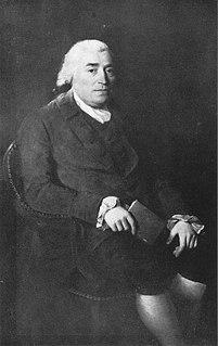
William Fairfax (1691–1757) was a political appointee of the British Crown and a politician: he was Collector of Customs in Barbados, and Chief Justice and governor of the Bahamas; he served as Customs agent in Marblehead, Massachusetts before being reassigned to the Virginia colony.
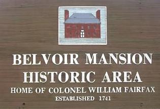
Belvoir was the agricultural forced labor camp and estate of colonial Virginia's prominent William Fairfax family. Built with the forced labor of enslaved people, it sat on the west bank of the Potomac River in Fairfax County, Virginia, at the present site of Fort Belvoir. The main house — called Belvoir Manor or Belvoir Mansion — burned in 1783 and was destroyed during the War of 1812. The site has been listed on the National Register of Historic Places since 1973 as "Belvoir Mansion Ruins and the Fairfax Grave."

Fort Van Meter — or Fort VanMeter — is a mid-18th century frontier fort in the South Branch Potomac River Valley about 9 miles (14 km) southwest of Romney in Hampshire County, West Virginia, USA. It is located 15 miles (24 km) northeast of Moorefield and about a mile northeast of the former community of Glebe at the northern end of the rugged river gorge known as The Trough.
James Caudy was an American frontiersman, settler, and landowner in the Ridge-and-Valley Appalachians of the Colony of Virginia—present-day West Virginia. Caudy was born in the Netherlands, immigrated to the Thirteen Colonies in the 1730s, and settled within the Cacapon River valley near present-day Capon Bridge in Hampshire County. As early as 1741, Caudy was associated with the arrangement and development of transportation routes throughout present-day Hampshire County. Caudy twice hosted George Washington; first during his surveying expedition in 1748 and again upon Washington's 1750 return to the Cacapon River valley.
References
- ↑ U.S. Geological Survey Geographic Names Information System: Fort Cox, West Virginia
- ↑ Lewis, Virgil A. (1906). Biennial Report of the Department of Archives and History of the State of West Virginia. Charleston, WV: The Tribune Printing Company. p. 208.
| This military base or fortification article is a stub. You can help Wikipedia by expanding it. |