
Inwood Hill Park is a 196 acres (79 ha) public park in the Inwood neighborhood of Manhattan, New York City, operated by the New York City Department of Parks and Recreation. On a high schist ridge that rises 200 feet (61 m) above the Hudson River from Dyckman Street to the northern tip of the island, Inwood Hill Park's densely folded, glacially scoured topography contains the largest remaining old-growth forest on the island of Manhattan. The area is also known as the Shorakapkok Preserve, shorakapkok meaning 'the sitting place' in the Munsee language used by the Wecquaesgeek tribe who inhabited the area for nearly 700 years. Unlike other Manhattan parks, Inwood Hill Park is largely natural and consists of mostly wooded, non-landscaped hills.
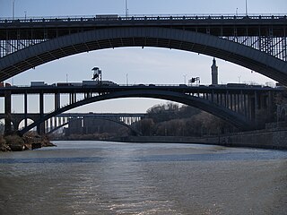
The Harlem River is an 8-mile (13 km) tidal strait in New York City, New York, flowing between the Hudson River and the East River and separating the island of Manhattan from the Bronx on the United States mainland.

Fort Greene Park is a city-owned and -operated park in Fort Greene, Brooklyn. The 30.2-acre (12.2 ha) park was originally named after the fort formerly located there, Fort Putnam, itself was named for Rufus Putnam, George Washington's chief of engineers in the Revolutionary War.

Fort Lafayette was an island coastal fortification in The Narrows of New York Harbor, built offshore from nearby Fort Hamilton at the southern tip of what is now the Bay Ridge neighborhood in the New York City borough of Brooklyn at the western end of Long Island. The fort was built on a natural off-shore island shoal, known as Hendrick's Reef. Construction on the fort began during the War of 1812 (1812-1815), with the British and was completed almost a decade later in 1822, as part of the continuing seacoast defense systems of the United States, built-up over the next two and half centuries with waterfront / island fortifications and artillery batteries outside seaport cities, mouths of rivers / bays and various strategic points, along the East Coast and southern Gulf of Mexico.
Vanderbilt Avenue is the name of three thoroughfares in the New York City boroughs of Brooklyn, Manhattan, and Staten Island. They were named after Cornelius Vanderbilt (1794–1877), the builder of Grand Central Terminal in Midtown Manhattan.

Andrew Haswell Green was an American lawyer, city planner, and civic leader who was influential in the development of New York City. Green was responsible for Central Park, the New York Public Library, the Bronx Zoo, the American Museum of Natural History, the Metropolitan Museum of Art, and also participated in or led significant projects, such as Riverside Drive, Morningside Park, Fort Washington Park, and protecting the Hudson River Palisades from destruction. Green is considered "the Father of Greater New York" for his last project to consolidate the city with neighboring towns, chairing the 1897 committee that drew up the plan of amalgamation.

Harlem Meer is a man-made lake at the northeast corner of New York City's Central Park. It lies west of Fifth Avenue, south of 110th Street, and north of the Conservatory Garden, near the Harlem and East Harlem neighborhoods of Manhattan. The lake, as originally constructed, was 12.634 acres (51,130 m2), but after the completion in 1966 of the Lasker skating rink and swimming pool, it was reduced to approximately 11 acres (45,000 m2) in area and approximately 0.75 miles (1.21 km) in circumference.
Fort Howard was a military installation located on the North Point peninsula, overlooking the main channel of the Patapsco River leading into the harbor of Baltimore, Maryland, USA. Although militarily important since the early 19th century, its surviving elements and name date to the Spanish–American War. It was named by Elihu Root, Secretary of War under President Theodore Roosevelt, in 1902 after Colonel John Eager Howard (1752–1827). The installation earned the nickname the "Bulldog at Baltimore's Gate", serving as the coastal artillery headquarters for Baltimore, Maryland. Fort Howard's historical significance is its military connection with the War of 1812, the Spanish–American War, and World War II.

Fort Bayard was an earthwork fort constructed in 1861 northwest of Tenleytown in the District of Columbia as part of the defenses of Washington, D.C., during the American Civil War. It never faced major opposition during the conflict and was decommissioned following the surrender of Robert E. Lee's Army of Northern Virginia. Named after Brigadier General George Dashiell Bayard, who was killed at the Battle of Fredericksburg, the site of the fort is in Boundary Park, located at the intersection of River Road and Western Avenue NW in Washington, D.C., and is maintained by the U.S. National Park Service. No trace of the fort remains, though a marker commemorating its existence has been erected by the Park Service.

Blockhouse No. 1, colloquially known as The Blockhouse, is a small fort in the North Woods section of Central Park, Manhattan, New York City. Finished in 1814, the Blockhouse is the second-oldest structure in the park, after Cleopatra's Needle, and the oldest surviving structure originally built within the park site. It is located on an overlook of Manhattan schist, with a clear view of the flat surrounding areas north of Central Park.

The Central Park Mall is a pedestrian esplanade in Central Park, in Manhattan, New York City. The mall, leading to Bethesda Fountain, provides the only purely formal feature in the naturalistic original plan of Frederick Law Olmsted and Calvert Vaux for Central Park.

The Civil War Defenses of Washington were a group of Union Army fortifications that protected the federal capital city, Washington, D.C., from invasion by the Confederate States Army during the American Civil War.

The Sawkill or Saw-kill was the largest hydrological network on Manhattan island in New York City before the Dutch colony of New Netherland was founded in 1624. This 44,980-foot-long (13,710 m) stream began "within four blocks of the Hudson River":
A rill flowing east from the rocky ridge overlooking Bloomingdale Village, which rose near Ninth Avenue and 85th Street, flowed in a southerly direction through Manhattan Square, where it spread into a little pond, and then turned east, crossing Central Park to Fifth Avenue, receiving three tributaries within its limits, two from the north and one from the south. At 75th Street near Third Avenue it was joined by another stream. Near this junction the old Boston Post Road crossed it, and then from this point, the stream ran due east to its outlet near the foot of 75th Street
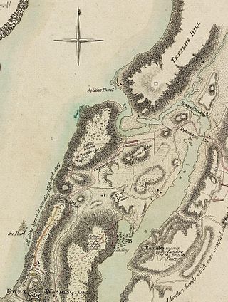
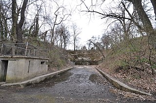
Fort Cockhill was an 18th-century military fortification located on Cox's Hill or Tubby Hook Hill, now known as the present-day Inwood Hill Park in Manhattan, New York City. A small, circular earthwork structure, in height some ten or twelve feet and equipped with two cannon, it was situated at the northwestern extremity of Tubby Hook Hill, at a point overlooking both the Hudson River and the Harlem River valley.

McGowan's Pass is a topographical feature of Central Park in New York City, just west of Fifth Avenue and north of 102nd Street. It pre-dates the park, and was incorporated into the park's East Drive in the early 1860s, during the park's creation. A steep hill descending into a switchback road, it is a popular training route for competitive bicyclists and runners.

Nutter's Battery is a scenic overlook in the North Woods of Central Park in Manhattan, New York City, overlooking the Harlem Meer to the north. The battery was built during the War of 1812 as a small part of an extensive system of fortification intended to defend against a British invasion from the north. After the war, the wall fell into ruin and eventually disappeared. The Parks Department built a low wall in 1945 to mark the spot, and the Central Park Conservancy rebuilt the wall in 2014, adding paths and planting. The battery was named after Valentine Nutter, who owned the surrounding property.

Fort Clinton was a stone-and-earthworks fortification on an elevation within what is now Central Park in New York City. It was built in 1814 near the present line of 107th Street, slightly west of Fifth Avenue. According to maps of the time, Fort Clinton was the easternmost of a connected series of forts, connected to Nutter's Battery on the west by earthworks and a gatehouse over the Old Post Road at the bottom of McGowan's Pass. Fort Clinton and Nutter's Battery were commanded from a third fort at the top of the pass, Fort Fish, which had a sweeping view of Long Island Sound, northern Manhattan, and Westchester County. Fort Fish was across the road from Fort Clinton and connected to Nutter's Battery by another line of earthworks.
Travis Triangle is a narrow green space in the Murray Hill/Flushing neighborhoods of Queens, New York City. It is formed by the separation of Murray Street and Murray Lane, both of which were named after the Murray family, which owned land on the site of these streets from the late colonial period through the early 19th century. In 1932, New York City's Board of Aldermen passed a resolution to name this site Travis Triangle in honor of local American Civil War veteran Ira Underhill Travis, who fought under the name Ira Wilson, in the 11th New York Volunteer Infantry Regiment also known as Colonel Elmer E. Ellsworth’s Zouaves.

Fort George Amusement Park was a trolley park and amusement park that operated in the Washington Heights and Inwood neighborhoods of Upper Manhattan, New York City, in the late 19th and early 20th centuries. It occupied an area between 190th and 192nd Streets east of Amsterdam Avenue, within present-day Highbridge Park.


