Related Research Articles

Marshall County is a county in the U.S. state of West Virginia. At the 2010 census, the population was 33,107. Its county seat is Moundsville. With its southern border at what would be a continuation of the Mason-Dixon line to the Ohio River, it forms the base of the Northern Panhandle of West Virginia.

Hampshire County is a county in the U.S. state of West Virginia. As of the 2010 census, the population was 23,964. Its county seat is Romney, West Virginia's oldest town (1762). The county was created by the Virginia General Assembly in 1754, from parts of Frederick and Augusta Counties (Virginia) and is the state's oldest county. The county lies in both West Virginia's Eastern Panhandle and Potomac Highlands regions.

Fort Ashby is a census-designated place (CDP) in Mineral County, West Virginia, USA, along Patterson Creek. It is part of the Cumberland, MD-WV Metropolitan Statistical Area. The population was 1,380 at the 2010 census. The community was originally chartered as Frankfort and then known as Alaska before it took the name of its well-known historic landmark.

The Northwest Territory, also known as the Old Northwest and formally known as the Territory Northwest of the River Ohio, was formed from unorganized western territory of the United States after the American Revolutionary War. Established in 1787 by the Congress of the Confederation through the Northwest Ordinance, it was the nation's first post-colonial organized incorporated territory.
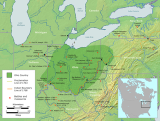
The Ohio Country was a name used in the mid- to late 18th century for a region of North America west of the Appalachian Mountains and north of the upper Ohio and Allegheny rivers, extending to Lake Erie. The area encompassed roughly northwestern West Virginia, Western Pennsylvania, all of the present-day state of Ohio, and a wedge of southeastern Indiana.

The Ohio Company, formally known as the Ohio Company of Virginia, was a land speculation company organized for the settlement by Virginians of the Ohio Country and to trade with the Native Americans. The company had a land grant from Britain and a treaty with Indians, but France also claimed the area, and the conflict helped provoke the outbreak of the French and Indian War.
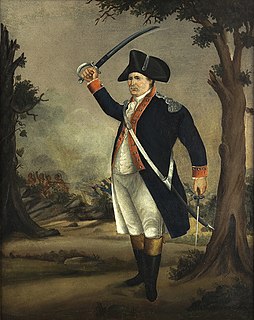
William Darke was an American soldier who served with British forces before the Revolutionary War. He served with British regulars commanded by Major General Edward Braddock in his 1755 expedition to the French-controlled Ohio Valley, as part of the French and Indian War. The British forces were defeated and Braddock died.

Indian Mound Cemetery is a cemetery located along the Northwestern Turnpike on a promontory of the "Yellow Banks" overlooking the South Branch Potomac River and Mill Creek Mountain in Romney, West Virginia, United States. The cemetery is centered on a Hopewellian mound, known as the Romney Indian Mound. Indian Mound Cemetery is also the site of Fort Pearsall, the Confederate Memorial, Parsons Bell Tower, and reinterments from Romney's Old Presbyterian Cemetery. The cemetery is currently owned and maintained by the Indian Mound Cemetery Association, Inc.

The Moneton were a historical Native American tribe from West Virginia. In the late seventeenth century they lived in the Kanawha Valley, near the Kanawha and New Rivers.
Buffalo Creek is a 4.1-mile-long (6.6 km) free-flowing tributary stream of the South Branch Potomac River, itself a tributary of the Potomac River, making it a part of the Chesapeake Bay watershed. Buffalo Creek is located in west-central Hampshire County in the U.S. state of West Virginia. Because the stream flows through several small farms, Buffalo Creek primarily serves agriculture purposes with segments used for livestock watering.

Ridgedale is a 19th-century Greek Revival plantation house and farm on a plateau overlooking the South Branch Potomac River north of Romney, West Virginia, United States. The populated area adjacent to Washington Bottom Farm is known as Ridgedale. The farm is connected to West Virginia Route 28 via Washington Bottom Road.
Captain William Foreman was a colonial American officer from Hampshire County, Virginia, who was killed during an Indian ambush at the McMechen Narrows on the Ohio River south of Wheeling, Virginia in 1777.
The Wrought Iron Bridge Company was a bridge fabrication and construction company based in Canton, Ohio, United States. It specialized in the fabrication of iron truss bridges and was a prolific bridge builder in the late 19th century. It was one of the 28 firms consolidated by J. P. Morgan into the American Bridge Company in 1900. Many of its bridges have been listed on the National Register of Historic Places.

Wappocomo is a late 18th-century Georgian mansion and farm overlooking the South Branch Potomac River north of Romney, Hampshire County, West Virginia, USA. It is located along Cumberland Road and the South Branch Valley Railroad.
Moorefield and North Branch Turnpike was a turnpike in the U.S. state of Virginia built to facilitate travel and commerce between the Baltimore and Ohio Railroad at Green Spring on the North Branch Potomac River and Moorefield. Today, Green Spring Road, Harriott-Wappocomo Road, and West Virginia Route 28 encompass most of the Moorefield and North Branch Turnpike's original route.

Angus McDonald was a prominent Scottish American military officer, frontiersman, sheriff and landowner in Virginia.
Isaac Parsons was an American slave owner, politician, and militia officer in the U.S. state of Virginia. Parsons served as a member of the Virginia House of Delegates representing Hampshire County from 1789 until his death in 1796. Following an act of the Virginia General Assembly in 1789, Parsons was appointed to serve as a trustee for the town of Romney. In 1790, Parsons began serving as a justice for Hampshire County. He served as a captain in command of a company in the Virginia militia during the American Revolutionary War and continued to serve as a captain in the Hampshire County militia following the war. Parsons operated a public ferry across the South Branch Potomac River, and later died from drowning in the river in 1796. Parsons was the grandfather of Isaac Parsons (1814–1862), who also represented Hampshire County in the Virginia House of Delegates and served as an officer in the Confederate States Army.
Isaac Parsons was an American planter, politician, and military officer in the U.S. state of Virginia. Parsons served as a Justice of the Peace of Hampshire County's District 3 from 1852 to 1853. He later served as a member of the Virginia House of Delegates representing Hampshire County from 1854 until 1857. Parsons was the grandson of Virginia House Delegate Isaac Parsons (1752–1796), the great-grandson of Colonial Virginia military officer William Foreman, and the grandfather of First Lady of West Virginia, Edna Brady Cornwell (1868–1958).
Valley was a populated place and post office on the South Branch line of the Baltimore and Ohio Railroad in the U.S. state of West Virginia. It was centered near the intersection of West Sioux Lane and Depot Valley Road, now located within the present-day corporate boundaries of Romney. Valley developed in 1884 following the completion of the South Branch line when the rail line's original southern terminus and corresponding Romney Depot were built there. The United States Post Office Department established a post office at Valley on May 19, 1928, remaining in operation until its disestablishment on June 15, 1937. Following the closure of Valley's post office, its mail was routed through the post office in Romney.
References
- ↑ U.S. Geological Survey Geographic Names Information System: Fort Forman
- ↑ Lewis, Virgil A. (1906). Biennial Report of the Department of Archives and History of the State of West Virginia. Charleston, WV: The Tribune Printing Company. p. 210.