
Petersburg is an independent city in the Commonwealth of Virginia in the United States. As of the 2020 census, the population was 33,458 with a majority black American. The Bureau of Economic Analysis combines Petersburg with Dinwiddie County for statistical purposes. The city is 21 miles (34 km) south of the commonwealth (state) capital city of Richmond.

Colonial Heights is an independent city in the Commonwealth of Virginia. As of the 2020 census, the population was 18,170. The Bureau of Economic Analysis combines the City of Colonial Heights with Dinwiddie County for statistical purposes.
Fort Henry is the name of:
Lewis Wetzel was an American scout and frontiersman. Because of how feared he was by the Native American Tribes, he was nicknamed "Death Wind". He stood about 6 ft with dark brown hair. He was an expert with a knife and tomahawk and was even deadlier with a black powder rifle, or musket. While running at full speed, Death Wind could load powder from his powder horn, a ball round and pack it, aim it and fire with expert marksmanship every time. Raised in what is now the Northern Panhandle of West Virginia, his exploits were once hailed as similar to those of Daniel Boone.

Fort Ouiatenon, built in 1717, was the first fortified European settlement in what is now Indiana, United States. It was a palisade stockade with log blockhouse used as a French trading post on the Wabash River located approximately three miles southwest of modern-day West Lafayette. The name 'Ouiatenon' is a French rendering of the name in the Wea language, waayaahtanonki, meaning 'place of the whirlpool'. It was one of three French forts built during the 18th century in what was then New France, later the Northwest Territory and today the state of Indiana, the other two being Fort Miami and Fort Vincennes. A substantial French settlement grew up around the fort in the mid-18th century. It was ceded to the British and abandoned after the French and Indian War. Later, it passed into Indian hands and was destroyed in 1791 by American militia during the Northwest Indian War. It was never a U.S. fort. The original site was rediscovered in the 1960s; the archaeological site was listed on the National Register of Historic Places in 1970, and was designated a National Historic Landmark in 2021.

Fort Kearny was a historic outpost of the United States Army founded in 1848 in the Western United States during the middle and late 19th century. The fort was named after Colonel and later General Stephen Watts Kearny. The outpost was located along the Oregon Trail near Kearney, Nebraska. The town of Kearney took its name from the fort. The "e" was added to Kearny by postmen who consistently misspelled the town name. A portion of the original site is preserved as Fort Kearny State Historical Park by the Nebraska Game and Parks Commission.
Blandford Cemetery is a historic cemetery located in Petersburg, Virginia. Although in recent years it has attained some notoriety for its large collection of more than 30,000 Confederate graves, it contains remains of people of all classes and races as well as veterans of every American war. It holds the largest mass grave of 30,000 Confederates killed in the Siege of Petersburg (1864–65) and other battles during the American Civil War. Although only 3,700 names of the interred are known, it was listed on the National Register of Historic Places in 1992, in part through the efforts of Charlotte Irving, first president of the Historic Blandford Cemetery Foundation. In addition to this cemetery's historic African American section discussed below, it is located adjacent to the People's Memorial Cemetery, a historic African-American cemetery, and small cemeteries containing additional dead from the lengthy Siege of Petersburg and Battle of the Crater in 1864.

The Tri-Cities of Virginia is an area in the Greater Richmond Region which includes the three independent cities of Petersburg, Colonial Heights, and Hopewell and portions of the adjoining counties of Chesterfield, Dinwiddie, and Prince George in south-central Virginia. Other unincorporated communities located in the Tri-Cities area include Ettrick, Fort Gregg-Adams, and City Point, the latter formerly a historic incorporated town which was annexed to become part of the City of Hopewell.

Attakullakulla was an influential Cherokee leader and the tribe's First Beloved Man, serving from 1761 to around 1775. His son was Dragging Canoe, the first leader of the Chickamauga faction of the Cherokee tribes.
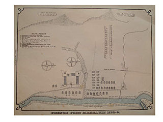
Fort Machault was a fort built by the French in 1754 near the confluence of French Creek with the Allegheny River, in northwest Pennsylvania. The fort helped the French control these waterways, part of what was known as the Venango Path from Lake Erie to the Ohio River. It was one of four forts designed to protect French access to the Ohio Country and connections between its northern and southern colonies. From north to south the forts were Fort Presque Isle, Fort Le Boeuf, Fort Machault, and Fort Duquesne. In January 1759 the British launched an expedition to attack Fort Machault, but had to turn back after encountering resistance from French-Allied Native Americans. The fort was abandoned by the French in August 1759, and burned so that the British could not use it. It was replaced by the British in 1760 with Fort Venango.

The Native American tribes in Virginia are the Indigenous peoples whose tribal nations historically or currently are based in the Commonwealth of Virginia in the United States of America.

During the 18th and early 19th centuries, the French, British and U.S. forces built and occupied a number of forts at Vincennes, Indiana. These outposts commanded a strategic position on the Wabash River. The names of the installations were changed by the various ruling parties, and the forts were considered strategic in the French and Indian War, the American Revolutionary War, the Northwest Indian War and the War of 1812. The last fort was abandoned in 1816.
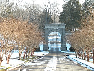
Abraham Wood (1610–1682), sometimes referred to as "General" or "Colonel" Wood, was an English fur trader, militia officer, politician and explorer of 17th century colonial Virginia. Wood helped build and maintained Fort Henry at the falls of the Appomattox in present-day Petersburg. He also served in the Virginia House of Burgesses and as a member of the Virginia Governor's Council.
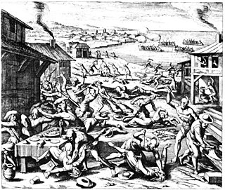
The Anglo–Powhatan Wars were three wars fought between settlers of the Colony of Virginia and the Powhatan People of Tsenacommacah in the early 17th century. The first war started in 1609 and ended in a peace settlement in 1614. The second war lasted from 1622 to 1632. The third war lasted from 1644 until 1646 and ended when Opechancanough was captured and killed. That war resulted in a defined boundary between the Indians and colonial lands that could only be crossed for official business with a special pass. This situation lasted until 1677 and the Treaty of Middle Plantation which established Indian reservations following Bacon's Rebellion.
The Appomattoc were a historic tribe of Virginia Indians speaking an Algonquian language, and residing along the lower Appomattox River, in the area of what is now Petersburg, Colonial Heights, Chesterfield and Dinwiddie Counties in present-day southeast Virginia.
Preston, also known as Preston Bend, is an unincorporated community and census-designated place located on the Red River in Grayson County, Texas, United States. It grew in the 19th century at the intersection of several military and trade roads and was an important crossing on the Shawnee cattle trail. Preston lost prominence after the MK&T railroad bypassed the town to the east, leading to a decline in traveler and cattle drive traffic. Much of its former town site is submerged beneath the waters of Lake Texoma. Its population was 2,096 as of the 2010 census.
The territorial era of Minnesota lasted from the Louisiana Purchase in 1803 to Minnesota's achieving statehood in 1858. The Minnesota Territory itself was formed only in 1849 but the area had a rich history well before this. Though there was a long history of European presence in the area before 19th century, it was during the 19th century that the United States began to establish a firm presence in what would become Minnesota.
The history of Petersburg, Virginia, United States as a modern settlement begins in the 17th century when it was first settled. The city was incorporated in 1748. It was occupied by the British during the American Revolutionary War, and Major-General William Phillips died of fever at Blandford during bombardment from the Marquis de Lafayette's positions north of the river. After the war, it became a destination for many free blacks in Virginia, as well as a growing hub for railroads. By 1860, it was the second largest city in Virginia. For nine months in 1864 and 1865 it was the subject of the Siege of Petersburg; the fall of the city unleashed a chain of events over the following two weeks that resulted in the end of the American Civil War. After the war, it again flourished as a destination for Freedmen. Petersburg was a notable focal point in the organization of the Civil Rights Movement in the mid-20th century. In the late 20th century, the city suffered significant economic decline.
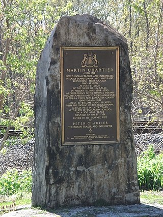
Martin Chartier was a French-Canadian explorer and trader, carpenter and glove maker. He lived much of his life amongst the Shawnee Native Americans in what is now the United States.

The 127th United States Colored Infantry was an American infantry regiment which fought with the Union Army during the American Civil War. Staffed by African American enlisted men who were placed under the command of white officers, the regiment was formed and trained at Camp William Penn near Philadelphia, Pennsylvania between August 23 and September 10, 1864.
