
Kingston is a city in Ontario, Canada, on the northeastern end of Lake Ontario. It is at the beginning of the St. Lawrence River and at the mouth of the Cataraqui River, the south end of the Rideau Canal. Kingston is midway between Toronto, Ontario, and Montreal, Quebec, and is also near the Thousand Islands, a tourist region to the east, and the Prince Edward County tourist region to the west. Kingston is nicknamed the "Limestone City" because it has many heritage buildings constructed using local limestone.

Thunder Bay is a city in and the seat of Thunder Bay District, Ontario, Canada. It is the most populous municipality in Northwestern Ontario and the second most populous municipality in Northern Ontario; its population is 108,843 according to the 2021 Canadian Census. Located on Lake Superior, the census metropolitan area of Thunder Bay has a population of 123,258 and consists of the city of Thunder Bay, the municipalities of Oliver Paipoonge and Neebing, the townships of Shuniah, Conmee, O'Connor, and Gillies, and the Fort William First Nation.

Niagara-on-the-Lake is a town in Ontario, Canada. It is located on the Niagara Peninsula at the point where the Niagara River meets Lake Ontario, across the river from New York, United States. Niagara-on-the-Lake is in the Niagara Region of Ontario and is the only town in Canada that has a lord mayor. It has a population of 19,088.
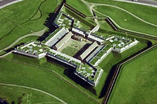
Fort Stanwix was a colonial fort whose construction commenced on August 26, 1758, under the direction of British General John Stanwix, at the location of present-day Rome, New York, but was not completed until about 1762. The bastion fort was built to guard a portage known as the Oneida Carry during the French and Indian War. Fort Stanwix National Monument, a reconstructed structure built by the National Park Service, now occupies the site.
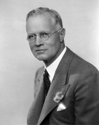
Robert James Manion was a Canadian politician who led the Conservative Party of Canada from 1938 to 1940. Prior to his leadership of the party, he served in Prime Minister Arthur Meighen and R.B. Bennett's cabinets.
Fort William may refer to:
Manitou Island may refer to:
Eabametoong, also known as Fort Hope or Eabamet Lake by Canada Post, is an Ojibwe First Nations band government in Kenora District, Ontario, Canada. Located on the shore of Eabamet Lake in the Albany River system, the community is located approximately 300 km (190 mi) northeast of Thunder Bay and is accessible only by airplane via Fort Hope Airport or water, or by winter/ice roads, which connect the community to the Northern Ontario Resource Trail. The Eabametoong First Nation Reserve is completely surrounded by territory of the Unorganized Kenora District.
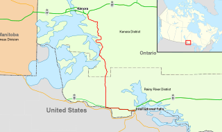
King's Highway 71, commonly referred to as Highway 71, is a provincially maintained highway in the Canadian province of Ontario. The 194-kilometre-long (121 mi) route begins at the Fort Frances–International Falls International Bridge in Fort Frances, continuing from US Highway 53 (US 53) and US 71 in Minnesota, and travels west concurrently with Highway 11 for 40 kilometres (25 mi) to Chapple. At that point, Highway 11 continues west while Highway 71 branches north and travels 154 kilometres (96 mi) to a junction with Highway 17 just east of Kenora. Highway 71 forms a branch of the Trans-Canada Highway for its entire length, with the exception of the extremely short segment south of Highway 11 in Fort Frances.
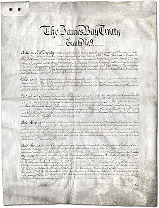
Treaty No. 9 is a numbered treaty first signed in 1905–1906 between Anishinaabe and Omushkegowuk Cree communities and the Canadian Crown, which includes both the government of Canada and the government of the province of Ontario. It is commonly known as the "James Bay Treaty," since the eastern edge of the treaty territory is the shore of James Bay in Northern Ontario.

A street running train is a train which runs on a track built on public streets. The rails are embedded in the roadway, and the train shares the street with other users, such as pedestrians, cars and cyclists, thus often being referred to as running in mixed traffic or sharing the road with trains. For safety, street running trains travel more slowly than trains on dedicated rights-of-way. Needing to share the right-of-way with motor vehicles can cause delays and pose a safety risk.

NAC Air was a Canadian regional airline that began operations in 2000. Its main base was at the Thunder Bay International Airport. NAC Air was a 100% First Nations-owned company, owned by the communities of Eabametoong, Neskantaga, Webequie, Sachigo Lake, and Sandy Lake
Leeblain is a ghost town in the Canadian province of Ontario, located on the north shore of Gunflint Lake in the Thunder Bay District. Part of the ghost town is located within La Verendrye Provincial Park and is adjacent to the well known Boundary Waters Canoe Area Wilderness in the Boundary Waters between Canada and the United States.
This page is based on this
Wikipedia article Text is available under the
CC BY-SA 4.0 license; additional terms may apply.
Images, videos and audio are available under their respective licenses.