
La Fortaleza, also known as Palacio de Santa Catalina, has been the official residence of the governor of Puerto Rico since the 16th century, making it the oldest executive mansion in continuous use in the New World. Built between 1533 and 1540 by orders of Charles I of Spain, the structure was the first fortification constructed by the Spanish on San Juan Islet to defend San Juan Bay, the harbor of Old San Juan. La fortaleza, alongside El Morro, San Cristóbal, El Cañuelo, and other forts part of the Walls of Old San Juan, protected strategically and militarily important Puerto Rico, or La Llave de las Indias , from invasion by competing world powers and harassment by privateers and pirates during the Age of Sail. It was designated a World Heritage Site by UNESCO in 1983 as part of La Fortaleza and San Juan National Historic Site.

Castillo San Felipe del Morro, most commonly known as El Morro(The Promontory), is a large fortress and citadel in the historic district of Old San Juan, Puerto Rico. Commissioned by King Charles I of Spain in 1539, it was first built as a fortified tower in honor of King Philip II, who oversaw its expansion into a hornwork fort by 1595. Over the next 200 years, especially in the reign of King Charles III, El Morro continued to be developed to reach its current form in 1787. Rising 140 ft from the Atlantic shoreline with 18 to 25 ft thick walls, the six-leveled edifice stands on a steep, rocky headland promontory on San Juan Islet guarding the entry to San Juan Bay, the harbor of Old San Juan. El Morro, alongside La Fortaleza, San Cristóbal, El Cañuelo, and other forts part of the Walls of Old San Juan, protected strategically and militarily important Puerto Rico, or La Llave de las Indias , from invasion by competing world powers during the Age of Sail. It was designated a World Heritage Site by UNESCO in 1983.

Castillo San Cristóbal is a fortress in the historic district of Old San Juan, Puerto Rico, known as the largest fortification built by the Spanish in the New World. Dating back to defense expansions following attacks by the English in 1598 and the Dutch in 1625, it was first built in 1634 as the Garita del Diablo and an artillery platform. Over the next 150 years, especially in the reign of King Charles III of Spain, it continued to be developed into a bastion fort to reach its largest size in 1790. Rising 150 ft from the Atlantic shoreline, the three-level edifice stands on a hill at the northern coastline of San Juan Islet, guarding the land entry to Old San Juan. San Cristóbal, alongside El Morro, La Fortaleza, and other forts part of the Walls of Old San Juan, protected strategically and militarily important Puerto Rico, or La Llave de las Indias , from invasion by competing world powers during the Age of Sail. It was designated a World Heritage Site by UNESCO in 1983.
Fort Barrancas (1839) or Fort San Carlos de Barrancas is a United States military fort and National Historic Landmark in the former Warrington area of Pensacola, Florida, located physically within Naval Air Station Pensacola, which was developed later around it.

San Andrés y Sauces is a municipality on the island of La Palma, Province of Santa Cruz de Tenerife, Canary Islands, Spain. It is situated in the northeastern part of the island. The population of the municipality is 4,473 (2013) and the area is 42.75 km². The elevation of the largest village Los Sauces is 250 m. Los Sauces is 14 km north of the island capital Santa Cruz de La Palma. The municipality takes its name from the villages Los Sauces and San Andrés, 1.5 km southeast of Los Sauces, at the coast.
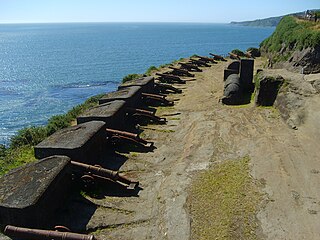
The Fort System of Valdivia is a series of Spanish colonial fortifications at Corral Bay, Valdivia and Cruces River established to protect the city of Valdivia, in southern Chile. During the period of Spanish rule (1645–1820), it was one of the biggest systems of fortification in the Americas. It was also a major supply source for Spanish ships that crossed the Strait of Magellan.

Fortín Solano is an eighteenth-century colonial fortification overlooking Puerto Cabello, Venezuela. With the Castillo San Felipe, an earlier fort built at sea level, it formed part of a complex of fortifications designed to protect Puerto Cabello and its important harbour from naval attacks. It was constructed c. 1766 by order of Don José Solano y Bote on behalf of the King of Spain. It has been described as the last military construction built in Venezuela during the colonial era.

On 18 February 1797, a fleet of 18 British warships under the command of Sir Ralph Abercromby invaded and took the Island of Trinidad. Within a few days the last Spanish Governor, Don José María Chacón surrendered the island to Abercromby.
Andrés Rodríguez de Villegas (1580–1631) was a Spanish soldier who served as governor and captain-general of the Province of Isla Margarita, Venezuela (1619–1626) and as governor of Spanish Florida (1630–1631).
Pablo de Hita y Salazar was a Spanish military officer who served as governor of Spanish Florida from 1675 to 1680. The territory at the time stretched from current-day Florida west to Texas and north to South Carolina. He was best known for his work devoted to construction of the Castillo de San Marcos in St. Augustine, the capital of La Florida.

Don Luis José Sartorius y Tapia, 1st Count of San Luis was a Spanish noble, politician and journalist who served as Prime Minister of Spain from 1853 to 1854, during the reign of Queen Isabella II.

The fourth siege of Badajoz took place from July to October 1658 during the Portuguese Restoration War. It was an attempt by a huge Portuguese army under the command of Joanne Mendes de Vasconcelos, governor of Alentejo, to capture the Spanish city of Badajoz, which was the headquarters of the Spanish Army of Extremadura. The fortifications of Badajoz were essentially medieval and considered vulnerable by the Portuguese, and had already been attacked by them three times during this war.
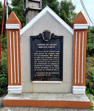
The Battle of Noveleta known as Battle of Calero Bridge was a major battle during the Philippine revolution and was one of the first engagements of the revolution in Cavite. In the latter part of the revolution, Noveleta played a key role for the Magdalo and Magdiwang factions. From its capture by the Magdiwang at the start of the revolution, various battles were fought and won by Filipino rebels in Cavite. Noveleta became the seat of the Magdiwang faction of the Katipunan.

The Castillo de Santo Domingo de Atarés is a small hexagonal hilltop fort in Havana built in 1767. Work commenced in 1763, around the same time as initial work on Castillo del Príncipe. It is located on La loma de Soto above the harbour. In 1982, the fort was inscribed on the UNESCO World Heritage List, along with other historic sites in Old Havana, because of the city's importance in the European conquest of the New World, its fortifications, and its unique architecture.
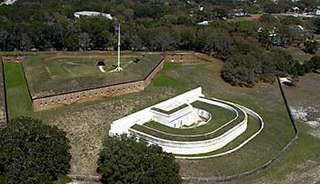
Fuerte de San José, also known as Fuerte de la Playa de Ponce, was an 18th-19th-century Spanish fortress located in Barrio Playa in the municipality of Ponce, Puerto Rico. It was part of a three-fort system design to defend the Port of Ponce, the Barrio Playa seaport village and the City of Ponce from seaborne attacks. However, only two of the three fortifications materialized, with Fuerte San José being the largest and most complete. The fort was in operation 125 years, from 1760 to 20 March 1885, and was demolished in 1907 by order of the Puerto Rico Legislature to make room for the growing civilian population of Barrio Playa. Fuerte de San José has been compared to Fortín de San Gerónimo in San Juan, in terms of design, purpose and size.

Spain–Trinidad and Tobago relations are the bilateral and diplomatic relations between these two countries. Spain has an embassy in Port of Spain, which is also accredited for Spanish consulates in other small nations of the Caribbean. Trinidad and Tobago does not have embassies or consulates in Spain.

The Royal Arsenal of Havana was located South East of the Campo de Marte and played a prominent role in Spanish shipbuilding in the 18th century. In total, seventy-four warships were built in Havana during this century.

The coastal 'fortifications' of Spain in America are the works of military engineering that bear witness to the four hundred years of Spanish presence in America. They were built from northern California to Tierra del Fuego. Their purpose was the defense of port towns against the attack of the fleets of the English, French and Dutch armies, as well as corsairs and pirates.

 Detail Isla Trinidad de Barlovento 1794
 "Plano de una Batería y muelle construido en Puerto España de la Ysla de Trinidad de Barlovento"
 "Nº 2 Plano y perfil de una Batería construida con tierra y fajinas, revestida de mampostería y situada en una altura inmediata la población de Puerto de España"

