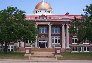
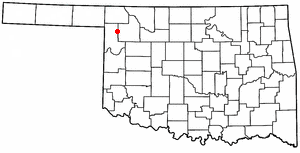
Woodward County is a county located in the U.S. state of Oklahoma. As of the 2010 census, the population was 20,081. Its county seat is Woodward.

Mayes County is a county located in the U.S. state of Oklahoma. As of the 2010 census, the population was 41,259. Its county seat is Pryor Creek. Named for Samuel Houston Mayes, Principal Chief of the Cherokee Nation from 1895 to 1899, it was originally created at the Sequoyah Convention in August 1905.

Harper County is a county located in the U.S. state of Oklahoma. As of the 2010 census, the population was 3,685, making it the fourth-least populous county in Oklahoma. The county seat is Buffalo. It was created in 1907 from the northwestern part of Woodward County, and named for Oscar Green Harper, who was clerk of the Oklahoma Constitutional Convention.

Ellis County is a county located on the western border of the U.S. state of Oklahoma. As of the 2010 census, the population was 4,151, making it the fifth-least populous county in Oklahoma. Its county seat is Arnett.
Lawton is a city in, and the county seat of, Comanche County, in the U.S. state of Oklahoma. Located in southwestern Oklahoma, approximately 87 mi (140 km) southwest of Oklahoma City, it is the principal city of the Lawton, Oklahoma, metropolitan statistical area. According to the 2010 census, Lawton's population was 96,867, making it the fifth-largest city in the state, and the largest in Western Oklahoma.
Fargo is a town in Ellis County, Oklahoma, United States. The population was 364 at the 2010 census. Fargo, like many towns in the region, has never fully recovered from the Dust Bowl years.

Gage is a town in Ellis County, Oklahoma, United States. The population was 442 at the 2010 census.

Fort Supply is a town in Woodward County, Oklahoma, United States, 13 kilometres (8.1 mi) northwest of the city of Woodward, the county seat. The population was 330 at the 2010 census.
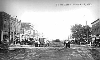
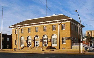
Woodward is a city in and the county seat of Woodward County, Oklahoma, United States. It is the largest city in a nine-county area. The population was 11,975 at the United States Census.
U.S. Route 412 is an east–west United States highway, first commissioned in 1982. U.S. 412 overlaps expressway-grade Cimarron Turnpike from Tulsa west to Interstate 35 and the Cherokee Turnpike from 5 miles (8.0 km) east of Chouteau, Oklahoma, to 8 miles (13 km) west of the Arkansas state line. It runs the entire length of the Oklahoma Panhandle and traverses the Missouri Bootheel.
U.S. Route 183 (US 183) is a north–south United States highway. The highway's northern terminus is in Presho, South Dakota, at an intersection with Interstate 90. Its southern terminus is in Refugio, Texas, at the southern intersection of U.S. Highway 77 and Alternate US 77.

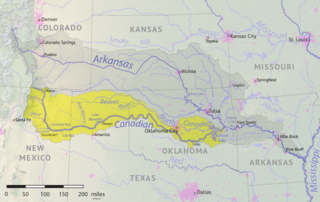
The North Canadian River is a river, 440 miles (710 km) long, in Oklahoma in the United States. It is a tributary of the Canadian River, draining an area of 17,955 square miles (46,500 km2) in a watershed that includes parts of northeastern New Mexico and the Texas Panhandle.
The Beaver River is an intermittent river, 280 miles (450 km) long, in western Oklahoma and northern Texas in the United States. It is a tributary of the North Canadian River, draining an area of 11,690 square miles (30,300 km2) in a watershed that extends to northeastern New Mexico and includes most of the Oklahoma Panhandle.

Keowee was a Cherokee town in the far northwest corner of present-day South Carolina. It was the principal town of what were called the seven Lower Towns, located along the Keowee River. Keowee was situated on the Lower Cherokee Traders' Path, part of the Upper Road through the Piedmont. In 1752 the Cherokee established New Keowee Town nearby, off the traders' path but in a more defensible location.

Boiling Springs State Park is a park built 6 miles (9.7 km) northeast of Woodward, Oklahoma, USA. It was built by the Civilian Conservation Corps in the 1930s.
U.S. Route 412 is a U.S. highway in the south-central portion of the United States, connecting Springer, New Mexico to Columbia, Tennessee. A 504.11-mile (811.29 km) section of the highway crosses the state of Oklahoma, traversing the state from west to east. Entering the state southwest of Boise City, US-412 runs the length of the Oklahoma Panhandle and serves the northern portion of the state's main body, before leaving the state at West Siloam Springs. Along the way, the route serves many notable cities and towns, including Boise City, Guymon, Woodward, Enid, and the state's second-largest city, Tulsa.
Preston, also known as Preston Bend, is an unincorporated community and census-designated place located on the Red River in Grayson County, Texas, United States. It grew in the 19th century at the intersection of several military and trade roads and was an important crossing on the Shawnee cattle trail. Preston lost prominence after the MK&T railroad bypassed the town to the east, leading to a decline in traveler and cattle drive traffic. Much of its former town site is submerged beneath the waters of Lake Texoma. Its population was 2,096 as of the 2010 census.
Wolf Creek is a tributary of the North Canadian River in Texas and Oklahoma in the United States. It begins in Ochiltree County, Texas, and flows generally westward and northwestward through Lipscomb and Ellis counties into Woodward County, Oklahoma, where it joins the Beaver River to form the North Canadian River. The creek drains an area of 1,922.6 square miles (4,980 km2).
Fort Supply Lake is in Woodward County, Oklahoma, about 1 mile (1.6 km) south of Fort Supply and 12 miles (19 km) northwest of Woodward. Managed by the U.S. Army Corps of Engineers, the lake surface covers 1,800 acres (7.3 km2). There are about 6,000 acres (24 km2) of public hunting land managed by the Corps of Engineers and the Oklahoma Department of Wildlife Conservation adjacent to the lake.