Fort Supply, Oklahoma

Last updated • 4 min readFrom Wikipedia, The Free Encyclopedia

Fort Supply, Oklahoma
Fsstockade.jpg
Artists Rendition of Fort Supply, 1869
OKMap-doton-FortSupply.PNG
Location of Fort Supply, Oklahoma
Coordinates: 36°34′20″N99°34′25″W / 36.57222°N 99.57361°W / 36.57222; -99.57361
Country United States
State Oklahoma
County Woodward
Area
[1]
  Total0.21 sq mi (0.56 km2)
  Land0.21 sq mi (0.56 km2)
  Water0.00 sq mi (0.00 km2)
Elevation
[2]
2,001 ft (610 m)
Population
 (2020)
  Total317
  Density1,474.42/sq mi (569.19/km2)
Time zone UTC-6 (Central (CST))
  Summer (DST) UTC-5 (CDT)
ZIP code
73841
Area code 580
FIPS code 40-27350 [3]
GNIS feature ID2412643 [2]

Fort Supply is a town in Woodward County, Oklahoma, United States, 13 kilometres (8.1 mi) northwest of the city of Woodward, the county seat. The population was 330 at the 2010 census.

Contents

History

The United States Army post of Fort Supply was established in 1868 as a "Camp of Supply" for the winter campaign that General Philip Sheridan led against the Southern Plains Indians. [4]

People established the town of Fitzgerald three miles west-southwest of the site of the former Fort Supply in 1902, but this town quickly failed.

Rancher H. H. Halsell sold the land one mile west of Fort Supply to territorial legislator James P. Gandy. Gandy hired surveyors to plat the land for a town site and founded the town of Supply in 1903. He moved most of the original buildings of Supply from the recently failed town of Fitzgerald. The Government established the first post office for the town of Supply on May 12, 1903. In the early years, area farmers and ranchers centered their economic trade around the town.

In 1908, the State of Oklahoma transformed Fort Supply, the derelict army post, into Western Oklahoma State Hospital, also known as Western State Hospital or Fort Supply State Hospital, the first state-operated mental institution of Oklahoma.

The Flood Control Act of 1936 provided for construction of a dam and reservoir one mile southeast of the town in the valley of Wolf Creek. Work began on the largest earthen dam in the United States of America in October 1938 and Fort Supply Lake was completed in May 1942. The United States Army Corps of Engineers administers Fort Supply Lake and the adjacent wildlife and recreation area.

On May 1, 1943, the people changed the name of the post office and town of Supply to Fort Supply.

On December 6, 1988, the State of Oklahoma located a new prison, William S. Key Correctional Center, on the grounds of nearby former Fort Supply. Western State Psychiatric Center also has operations on the grounds. Agriculture and employment at these state institutions form the economic base of the community of Fort Supply.

Geography

According to the United States Census Bureau, the town has a total area of 0.2 square miles (0.52 km2), all land.

Fort Supply Reservoir is directly south; [5] the Hal & Fern Cooper Wildlife Management Area, covering 16,080 acres and administered by the Oklahoma Department of Wildlife Conservation, [6] is to the east. [5]

Climate

Climate data for Fort Supply, Oklahoma. (Elevation 2,030ft)
MonthJanFebMarAprMayJunJulAugSepOctNovDecYear
Record high °F (°C)86
(30)
92
(33)
95
(35)
99
(37)
105
(41)
110
(43)
110
(43)
111
(44)
108
(42)
98
(37)
91
(33)
86
(30)
110
(43)
Mean daily maximum °F (°C)48.1
(8.9)
52.4
(11.3)
61.0
(16.1)
71.8
(22.1)
78.9
(26.1)
88.2
(31.2)
93.9
(34.4)
92.9
(33.8)
84.6
(29.2)
74.1
(23.4)
60.3
(15.7)
49.9
(9.9)
71.4
(21.9)
Mean daily minimum °F (°C)20.5
(−6.4)
24.7
(−4.1)
32.7
(0.4)
43.8
(6.6)
54.1
(12.3)
64.0
(17.8)
68.6
(20.3)
66.8
(19.3)
57.8
(14.3)
45.6
(7.6)
32.1
(0.1)
23.3
(−4.8)
44.5
(6.9)
Record low °F (°C)−18
(−28)
−12
(−24)
−10
(−23)
17
(−8)
27
(−3)
35
(2)
48
(9)
40
(4)
29
(−2)
15
(−9)
1
(−17)
−13
(−25)
−18
(−28)
Average precipitation inches (mm)0.60
(15)
1.00
(25)
1.71
(43)
1.94
(49)
3.72
(94)
3.40
(86)
2.43
(62)
2.63
(67)
2.10
(53)
2.03
(52)
1.12
(28)
0.84
(21)
23.53
(598)
Average snowfall inches (cm)2.8
(7.1)
3.4
(8.6)
2.5
(6.4)
0.5
(1.3)
0
(0)
0
(0)
0
(0)
0
(0)
0
(0)
0.1
(0.25)
0.8
(2.0)
2.3
(5.8)
12.3
(31)
Source: The Western Regional Climate Center [7]

Demographics

Historical population
CensusPop.Note
1910 169
1920 23136.7%
1930 230−0.4%
1940 41480.0%
1950 293−29.2%
1960 39434.5%
1970 55039.6%
1980 5591.6%
1990 369−34.0%
2000 328−11.1%
2010 3300.6%
2020 317−3.9%
U.S. Decennial Census [8]

As of the census [3] of 2000, there were 328 people, 136 households, and 98 families residing in the town. The population density was 1,458.4 inhabitants per square mile (563.1/km2). There were 171 housing units at an average density of 760.3 per square mile (293.6/km2). The racial makeup of the town was 95.73% White, 0.30% African American, 1.83% Native American, 0.61% from other races, and 1.52% from two or more races. Hispanic or Latino of any race were 0.91% of the population.

There were 136 households, out of which 25.7% had children under the age of 18 living with them, 61.8% were married couples living together, 7.4% had a female householder with no husband present, and 27.9% were non-families. 27.2% of all households were made up of individuals, and 14.0% had someone living alone who was 65 years of age or older. The average household size was 2.41 and the average family size was 2.91.

In the town, the population was spread out, with 24.4% under the age of 18, 7.0% from 18 to 24, 23.5% from 25 to 44, 27.4% from 45 to 64, and 17.7% who were 65 years of age or older. The median age was 41 years. For every 100 females, there were 86.4 males. For every 100 females age 18 and over, there were 86.5 males.

The median income for a household in the town was $30,893, and the median income for a family was $37,500. Males had a median income of $28,333 versus $20,833 for females. The per capita income for the town was $15,836. About 5.8% of families and 6.8% of the population were below the poverty line, including 13.4% of those under age 18 and none of those age 65 or over.

Historic sites

The nearby Cooper Bison Kill Site is on the National Register of Historic Places listings in Harper County, Oklahoma.

The Fort Supply Historic District is on the National Register of Historic Places listings in Woodward County, Oklahoma.

Related Research Articles

<span class="mw-page-title-main">Woodward County, Oklahoma</span> County in Oklahoma, United States

Woodward County is a county located in the U.S. state of Oklahoma. As of the 2020 census, the population was 20,470. Its county seat is Woodward.

<span class="mw-page-title-main">Harper County, Oklahoma</span> County in Oklahoma, United States

Harper County is a county located in the U.S. state of Oklahoma. As of the 2020 census, the population was 3,272, making it the third-least populous county in Oklahoma. The county seat is Buffalo. It was created in 1907 from the northwestern part of Woodward County, and named for Oscar Green Harper, who was clerk of the Oklahoma Constitutional Convention.

<span class="mw-page-title-main">Ellis County, Oklahoma</span> County in Oklahoma, United States

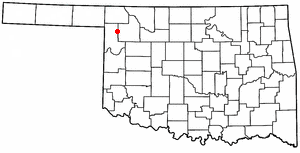
Ellis County is a county located on the western border of the U.S. state of Oklahoma. As of the 2020 census, the population was 3,749, making it the fifth-least populous county in Oklahoma. Its county seat is Arnett.

<span class="mw-page-title-main">Baxter Springs, Kansas</span> City in Cherokee County, Kansas

Baxter Springs is a city in Cherokee County, Kansas, United States, and located along Spring River. As of the 2020 census, the population of the city was 3,888.

<span class="mw-page-title-main">Springer, Oklahoma</span> Town in Oklahoma, United States

Springer is a town in Carter County, Oklahoma, United States. As of the 2020 census, the community had 685 residents. It is part of the Ardmore, Oklahoma Micropolitan Statistical Area.

<span class="mw-page-title-main">Medicine Park, Oklahoma</span> Town in Oklahoma, United States

Medicine Park is a town in Comanche County, Oklahoma, United States, situated in the Wichita Mountains near the entrance to the 60,000-acre (240 km2) Wichita Mountain Wildlife Refuge. Medicine Park has a long history as a vintage cobblestone resort town. Medicine Park is located near the city of Lawton and Fort Sill. It is an exurb, part of the Lawton Metropolitan Statistical Area. Many of the original structures are constructed of naturally formed cobblestones—these red granite cobblestones are unique to the Wichita Mountains. The population was 382 at the 2010 census.

<span class="mw-page-title-main">Arnett, Oklahoma</span> Town in Oklahoma, United States

Arnett is a town in and the county seat of Ellis County, Oklahoma, United States. The population was 495 at the time of the 2020 census.

<span class="mw-page-title-main">Fargo, Oklahoma</span> Town in Oklahoma, United States

Fargo is a town in Ellis County, Oklahoma, United States. The population was 312 at the time of the 2020 census. Fargo, like many towns in the region, has never fully recovered from the Dust Bowl years.

<span class="mw-page-title-main">Gage, Oklahoma</span> Town in Oklahoma, United States

Gage is a town in Ellis County, Oklahoma, United States. The population was 433 at the time of the 2020 census.

<span class="mw-page-title-main">Shattuck, Oklahoma</span> Town in Oklahoma, United States

Shattuck is a town in Ellis County, Oklahoma, United States. The population was 1,249 at the time of the 2020 census, a change from the 1,356 reported in the 2010 census.

<span class="mw-page-title-main">Maysville, Oklahoma</span> Town in Oklahoma, United States

Maysville is a town in Garvin and McClain counties, Oklahoma, United States. The population was 1,232 at the 2010 census, down from 1,313 in 2000.

<span class="mw-page-title-main">May, Oklahoma</span> Town in Oklahoma, United States

May is a town in Harper County, Oklahoma, United States. As of the 2020 census, the town’s population was 29.

<span class="mw-page-title-main">Tishomingo, Oklahoma</span> City in Oklahoma

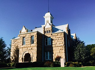
Tishomingo is the largest city in, and the county seat of, Johnston County, Oklahoma, United States. The population was 3,034 at the 2010 census, a decline of 4.1 percent from the figure of 3,162 in 2000. It was the first capital of the Chickasaw Nation, from 1856 until Oklahoma statehood in 1907. The city is home to Murray State College, a community college with an annual enrollment of 3,015 students. Tishomingo is part of the Texoma region.

<span class="mw-page-title-main">Cameron, Oklahoma</span> Town in Oklahoma, United States

Cameron is a town in Le Flore County, Oklahoma, United States. It is part of the Fort Smith, Arkansas-Oklahoma Metropolitan Statistical Area. The population was 302 at the 2010 census, a decline of 3.2 percent from the figure of 312 recorded in 2000.

<span class="mw-page-title-main">Pocola, Oklahoma</span> Town in Oklahoma, United States

Pocola is a town in Le Flore County, Oklahoma, United States. It is part of the Fort Smith, Arkansas-Oklahoma metropolitan area. The population was 4,056 in 2010, a gain of 1.6 percent over the figure of 3,994 recorded in 2000. Pocola is a Choctaw word meaning "ten", the approximate distance in miles from Fort Smith, Arkansas.

<span class="mw-page-title-main">Rock Island, Oklahoma</span> Town in Oklahoma, United States

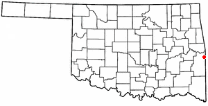
Rock Island is a town in Le Flore County, Oklahoma, United States. It is part of the Fort Smith, Arkansas-Oklahoma Metropolitan Statistical Area. The population was 646 at the 2010 census, a decline of 8.9 percent from the figure of 709 recorded in 2000.

<span class="mw-page-title-main">Byars, Oklahoma</span> Town in Oklahoma, United States

Byars is a town in McClain County, Oklahoma, United States. The population was 184 at the 2020 census, down from 255 at the 2010 census.

<span class="mw-page-title-main">Warner, Oklahoma</span> Town in Muskogee County, Oklahoma, United States

Warner is a town in Muskogee County, Oklahoma, United States. The population was 1,641 at the 2010 census, an increase of 14.8 percent over the figure of 1,430 recorded in 2000. The town is home to one of the two Connors State College campuses.

<span class="mw-page-title-main">Woodward, Oklahoma</span> City in Oklahoma, United States

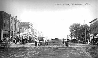
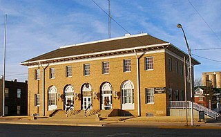
Woodward is a city in and the county seat of Woodward County, Oklahoma, United States. It is the largest city in a nine-county area. The population was 12,133 at the time of the 2020 census.

<span class="mw-page-title-main">Hammon, Oklahoma</span> Town in Oklahoma, United States

Hammon is a town in the U.S. state of Oklahoma, the majority of which is in Roger Mills County, but some of which extends into Custer County. It is located at the junction of Oklahoma State Highways 33 and 34.

References

  1. "ArcGIS REST Services Directory". United States Census Bureau. Retrieved September 20, 2022.
  2. 1 2 U.S. Geological Survey Geographic Names Information System: Fort Supply, Oklahoma
  3. 1 2 "U.S. Census website". United States Census Bureau . Retrieved January 31, 2008.
  4. "Fort Supply". Oklahoma Historical Society. Retrieved September 26, 2019.
  5. 1 2 "Fort Supply, Oklahoma". Google Maps. Retrieved July 12, 2020.
  6. "Cooper". Oklahoma Department of Wildlife Conservation. Retrieved July 12, 2020.
  7. "Seasonal Temperature and Precipitation Information". Western Regional Climate Center. Retrieved December 21, 2014.
  8. "Census of Population and Housing". Census.gov. Retrieved June 4, 2015.