Fort de l'Isle

Last updated

Fort de l'Isle is a site in Alberta, Canada, containing the remains of three trading posts that existed from 1799 to some time before 1808. The island the North Saskatchewan River on which the posts were located is about 47 miles west of the Saskatchewan border and about 7 miles north of Myrnam. [1] The west end of the island can be seen from the Alberta Highway 881 bridge.

Alberta Province of Canada

Alberta is a western province of Canada. With an estimated population of 4,067,175 as of 2016 census, it is Canada's fourth most populous province and the most populous of Canada's three prairie provinces. Its area is about 660,000 square kilometres (250,000 sq mi). Alberta and its neighbour Saskatchewan were districts of the Northwest Territories until they were established as provinces on September 1, 1905. The premier has been Rachel Notley since May 2015.

North Saskatchewan River river in Alberta and Saskatchewan

The North Saskatchewan River is a glacier-fed river that flows from the Canadian Rockies continental divide east to central Saskatchewan, where it joins with another major river to make up the Saskatchewan River. Its water flows eventually into the Hudson Bay.

Alberta Highway 881 Highway in Alberta

Alberta Provincial Highway No. 881, commonly referred to as Highway 881, is a highway split into two sections in northeast Alberta, Canada. Each section is over 200 kilometres (120 mi) in length; the southern portion runs from Highway 13 in Hardisty to Highway 55 northwest of Bonnyville, while the northern section stretches from Highway 55 in Lac La Biche to the south side of Fort McMurray, serving as an important alternate route to Highway 63. A 72-kilometre (45 mi) section of Highway 55 joins the two sections. Lac La Biche County is lobbying the Government of Alberta to renumber the section of Highway 881 between Lac La Biche and Fort McMurray to Highway 36.

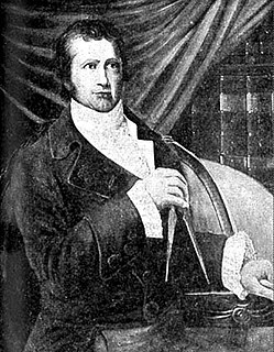
A Mr. de Rochblave of the XY Company may have been the first to arrive. [2] In 1800 both the North West Company and the Hudson's Bay Company decided to abandon their posts at Buckingham House/Fort George and move 20 miles upstream. Henry Hallett of the HBC had built the main buildings of Island House by that fall but could not build the stockade until spring, when it was possible to float logs downriver. François Decoigne from Fort Augustus upstream built Fort de l'Isle, between the other two, for the NWC. John McDonald of Garth ran the NWC post for the first two years.

North West Company

The North West Company was a fur trading business headquartered in Montreal from 1779 to 1821. It competed with increasing success against the Hudson's Bay Company in what is present-day Western Canada. With great wealth at stake, tensions between the companies increased to the point where several minor armed skirmishes broke out, and the two companies were forced by the British government to merge.

Hudsons Bay Company Canadian retail business group

The Hudson's Bay Company is a Canadian retail business group. A fur trading business for much of its existence, HBC now owns and operates retail stores in Canada, the United States, and parts of Europe including Belgium, the Netherlands, and Germany. The company's namesake business division is Hudson's Bay, commonly referred to as The Bay. Other divisions include Galeria Kaufhof, Home Outfitters, Lord & Taylor and Saks Fifth Avenue. HBC's head office is currently located in Brampton, Ontario. The company is listed on the Toronto Stock Exchange under the symbol "HBC".

In 1802 James King of the NWC and Joseph-Maurice Lamothe of the XY Company both left for an Indian camp about five days away to pick up furs that were owed to their respective companies. King tried to take furs that Lamothe claimed belonged to the XY Company, words were exchanged, and Lamothe shot King. From the time of Médard des Groseilliers it had been unclear whether Canadian jurisdiction extended beyond the Saint Lawrence basin. A Montreal grand jury brought a true bill against Lamothe, and he went to Montreal to stand trial but changed his mind and disappeared into the West to be beyond the reach of the law. This led to the passage of the Canada Jurisdiction Act of 1803, which provided that offenses committed in the West would be dealt with in the same way as those in Upper and Lower Canada. [1] It also allowed the Governor of Lower Canada to appoint justices of the peace in the West, something that would cause trouble later.

Médard Chouart des Groseilliers (1618–1696) was a French explorer and fur trader in Canada. He is often paired with his brother-in-law Pierre-Esprit Radisson, who was about 20 years younger. The pair worked together in fur trading and exploration. Their decision to enter British service led to the foundation of the Hudson's Bay Company in 1670. This company established trading posts and extensive relations with the First Nations in western Canada. It was highly influential in making the region amenable to British colonization. Radisson, with Groseiliers, also mapped many of the Great Lakes and trading routes used by settlers in the early 19th century.

Both posts were abandoned in favor of Fort Edmonton upstream or Paint Creek House/Fort Vermilion downstream. [1] In 1808 David Thompson passed by and implied in his journal that the forts were gone. A marker was erected in 1960. The surviving visible remains consist of cellar depressions and piles of chimney rock. The island can be reached only by boat or by snowshoes in winter; a fairly powerful outboard is needed because of the current.

Fort Edmonton was the name of a series of trading posts of the Hudson's Bay Company from 1795 to 1891, all of which were located in central Alberta, Canada. From 1795 to 1821 it was paired with the North West Company's Fort Augustus. It was the end point of the Carlton Trail, the main overland route for Metis freighters between the Red River Colony and the west and an important stop on the York Factory Express route between London, via Hudson Bay, and Fort Vancouver in the Columbia District.

Paint Creek House and Fort Vermilion were a pair of fur-trading posts on the North Saskatchewan River in Alberta, Canada, approximately 13 km (8.1 mi) west of the Saskatchewan border. Paint Creek House belonged to the Hudson's Bay Company (HBC) and Fort Vermilion to the North West Company (NWC). For background see Saskatchewan River fur trade.

David Thompson (explorer) British-Canadian fur trader, surveyor, and map-maker

David Thompson was a British-Canadian fur trader, surveyor, and map-maker, known to some native peoples as Koo-Koo-Sint or "the Stargazer." Over Thompson's career, he travelled some 90,000 kilometres (56,000 mi) across North America, mapping 4.9 million square kilometres of North America along the way. For this historic feat, Thompson has been described as the "greatest land geographer who ever lived."

See also

Related Research Articles

American Fur Company

The American Fur Company (AFC) was founded in 1808, by John Jacob Astor, a German immigrant to the United States. During the 18th century, furs had become a major commodity in Europe, and North America became a major supplier. Several British companies, most notably the North West Company and the Hudson's Bay Company, were eventual competitors against Astor and capitalized on the lucrative trade in furs. Astor capitalized on anti-British sentiments and his commercial strategies to become one of the first trusts in American business and a major competitor to the British commercial dominance in North American fur trade. Expanding into many former British fur-trapping regions and trade routes, the company grew to monopolize the fur trade in the United States by 1830, and became one of the largest and wealthiest businesses in the country.

Rocky Mountain House Town in Alberta, Canada

Rocky Mountain House is a town in west-central Alberta, Canada located approximately 77 km (48 mi) west of the City of Red Deer at the confluence of the Clearwater and North Saskatchewan Rivers, and at the crossroads of Highway 22 and Highway 11. The surrounding Clearwater County's administration office is located in Rocky Mountain House.

Cumberland House, Saskatchewan settlement in northwestern Saskatchewan, Canada

Cumberland House is a community in Census Division No. 18 in northeast Saskatchewan, Canada on the Saskatchewan River. It is the oldest settler community in Saskatchewan and has a population of about 2,000 people. Cumberland House Provincial Park, which provides tours of an 1890s powder house built by the Hudson's Bay Company, is located nearby.

Fort Espérance was a North West Company trading post near Rocanville, Saskatchewan from 1787 until 1819. It was moved three times and was called Fort John from 1814 to 1816. There was a competing XY Company post from 1801 to 1805 and a Hudson's Bay post nearby from 1813 to 1816. It was on the Qu'Appelle River about 20 km from that river's junction with the Assiniboine River and about 7 km west of the Manitoba border. It was on the prairie in buffalo country and was mainly used as a source of pemmican which was sent down the river to Fort Bas de la Rivière at the mouth of the Winnipeg River.

Fort de la Corne was one of the two French forts established on the Saskatchewan River in the 20 years between the end of La Vérendrye's push west from Lake Superior in 1731–1743 and the fall of New France in 1763.

Fort Carlton Protected area

Fort Carlton was a Hudson's Bay Company fur trade post from 1795 until 1885. It was rebuilt by the Saskatchewan government as a provincial historic park and can be visited today. It is about 65 kilometers north of Saskatoon.

William McGillivray fur trader

Lt.-Colonel The Hon. William McGillivray, of Chateau St. Antoine, Montreal, was a Scottish-born fur trader who succeeded his uncle as the last chief partner of the North West Company. He was elected a member of the Legislative Assembly of Lower Canada and afterwards was appointed to the Legislative Council of Lower Canada. In 1795, he was inducted as a member into the Beaver Club. During the War of 1812 he was given the rank of lieutenant colonel in the Corps of Canadian Voyageurs. He owned substantial estates in Scotland, Lower and Upper Canada. His home in Montreal was one of the early estates of the Golden Square Mile.

Alexander MacKay was a Canadian fur trader and explorer who worked for the North West Company and the Pacific Fur Company. He co-founded Fort Astoria near the mouth of the Columbia River on the Pacific coast.

Buckingham House (HBC) and Fort George (NWC) were two trading posts on the North Saskatchewan River near Elk Point, Alberta, from 1792 to 1800. Buckingham House belonged to the Hudson's Bay Company and Fort George to the North West Company. For background see Saskatchewan River fur trade.

Bas de la Rivière

Bas de la Rivière is a geographical area on both sides of the Winnipeg River at and near the mouth where it empties into Lake Winnipeg. It had a storied historical period in the opening of the west and the subsequent fur trade and settlement.

South Branch House was the only significant fur trading post on the South Saskatchewan River. Most trade was on the North Saskatchewan River which was closer to the wooded beaver country. West of the Saskatchewan River Forks the two rivers run parallel to the northeast for about 100 miles. Between them there is a fair amount of forest.

Fort Sturgeon (1776–1780) was the first trading post on the North Saskatchewan River. It was located about 4 miles west of Prince Albert, Saskatchewan. It and was also called Peter Pond Fort, Fort Pond, Fort la Prairie, Fort des Prairies, Lower Settlement and Fort Sturgeon River.

Pine Island Fort and Manchester House were trading posts on Pine Island, a small narrow island on the North Saskatchewan River in Saskatchewan, Canada, from 1786 to 1793. Pine Island Fort was a post of the North West Company while Manchester House was a post of the Hudson's Bay Company.

Saskatchewan River fur trade

Saskatchewan River fur trade The Saskatchewan River was one of the two main axes of Canadian expansion west of Lake Winnipeg. The other and more important one was northwest to the Athabasca Country. For background see Canadian canoe routes (early). The main trade route followed the North Saskatchewan River and Saskatchewan River, which were just south of the forested beaver country. The South Saskatchewan River was a prairie river with few furs.

Brandon House was a Hudson's Bay Company post or posts from 1793 to 1824. It was located at several places on the Assiniboine River between Brandon, Manitoba and the mouth of the Souris River about 21 miles southeast of Brandon. Because of its location near the Souris River it was a center for trade with the Mandans in North Dakota. It was moved four times and there were related forts nearby, so its history is necessarily complex. For background see Assiniboine River fur trade.

Fur trading on the Assiniboine River and the general area west of Lake Winnipeg began as early as 1731.

Lac Île-à-la-Crosse lake in Canada

Lac Île-à-la-Crosse is a lake in North-Central Saskatchewan, Canada on the Churchill River. It is basically Y-shaped. At the center of the Y is the town of Île-à-la-Crosse, the second oldest town in Saskatchewan. The Churchill exits the northeast arm and flows east to Hudson Bay through a series of lakes. The Churchill enters at the northwest arm called Aubichon Arm or Deep River. Upstream it leads northwest to Athabasca Country passing Churchill Lake, Peter Pond Lake, Lac La Loche and on to the Methye Portage leading to Lake Athabasca.

References

  1. 1 2 3 "Fort de l'Isle". Canada's Historic Places. Parks Canada. Retrieved 1 June 2012.
  2. Arthur Morton, A History of the Canadian West to 1870–71 (London: Thomas Nelson, 1939), p. 509.

Coordinates: 53°45′11″N111°9′27″W / 53.75306°N 111.15750°W / 53.75306; -111.15750

Geographic coordinate system Coordinate system

A geographic coordinate system is a coordinate system that enables every location on Earth to be specified by a set of numbers, letters or symbols. The coordinates are often chosen such that one of the numbers represents a vertical position and two or three of the numbers represent a horizontal position; alternatively, a geographic position may be expressed in a combined three-dimensional Cartesian vector. A common choice of coordinates is latitude, longitude and elevation. To specify a location on a plane requires a map projection.