
Fakhr al-Din Ma'n, commonly known as Fakhr al-Din II or Fakhreddine II, was the paramount Druze emir of Mount Lebanon from the Ma'n dynasty, an Ottoman governor of Sidon-Beirut and Safed, and the strongman over much of the Levant from the 1620s to 1633. For uniting modern Lebanon's constituent parts and communities, especially the Druze and the Maronites, under a single authority for the first time in history, he is generally regarded as the country's founder. Although he ruled in the name of the Ottomans, he acted with considerable autonomy and developed close ties with European powers in defiance of the Ottoman imperial government.
The Jumblatt family, also transliterated as Joumblatt and Junblat) is a Druze political dynasty. The current head of the family is veteran politician Walid Jumblatt, the son and successor of Kamal Jumblatt, one of the most influential figures in modern Lebanese politics. Other members of the family have contributed to cultural, economic and social life in Lebanon. Khaled Jumblatt, a distant cousin of Walid Jumblatt, held the position of minister of economy and was a prominent politician in Lebanon for many years until his death in 1993. Besides the Chouf, the family owns mansions and villas within the distinguished Clemenceau area of Beirut and in the northwest area of Sidon.

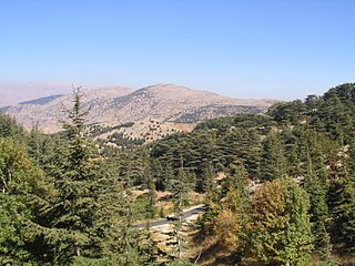
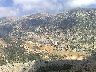
Chouf is a historic region of Lebanon, as well as an administrative district in the governorate (muhafazat) of Mount Lebanon.

Kadisha Valley, also romanized as the Qadisha Valley and also known as the Kadisha Gorge or Wadi Kadisha, is a gorge that lies within the Bsharri and Zgharta Districts of the North Governorate of Lebanon. The valley was carved by the Kadisha River, also known as the Nahr Abu Ali when it reaches Tripoli. Kadisha means "Holy" in Aramaic, and the valley is sometimes called the Holy Valley. It has sheltered Christian monastic communities for many centuries. The valley is located at the foot of Mount al-Makmal in northern Lebanon.

Kafarakab is the francophone spelling of the name of a village in the mountains of Lebanon. In Arabic, it means the home of the hawk. The village, which is located in the Matn District of the Mount Lebanon Governorate, is of particular significance because it is one of the various historic points of origin of the Maalouf family. It was founded c. 1560 AD when three families of the Maalouf clan, living at the time across the valley in the village of Mhaydse, received permission from the ruling emir to establish the village. The family history is traced back to the beginnings of Christianity in the Middle East beginning with the Ghassanid tribe, which converted to Christianity nearly 2,000 years ago. The family name is now widespread worldwide.
Al Shouf Cedar Nature Reserve is a nature reserve in the Chouf and Aley districts of Lebanon. It is located on the slopes of Jebel Baruk mountain and has an area of 550 km2 (210 sq mi), nearly 5.3% of the Lebanese territory, making it the largest natural reserve in Lebanon.
The Battle of Ain Dara occurred in the village of Ain Dara, in Mount Lebanon in 1711, between the Qaysi and Yamani, two rival tribo-political factions.
The tourism industry in Lebanon has been important to the local economy historically and comprises a major source of revenue for the country.

The Shihab dynasty is an Arab family whose members served as the paramount tax farmers and emirs of Mount Lebanon from the early 18th to mid-19th century, during Ottoman rule (1517–1918). Before then, the family had been in control of the Wadi al-Taym region, purportedly as early as the 12th century. During early Ottoman rule, they maintained an alliance and marital ties with the Ma'n dynasty, the Chouf-based, paramount Druze emirs and tax farmers of Mount Lebanon. When the last Ma'nid emir died without male progeny in 1697, the chiefs of the Druze in Mount Lebanon appointed the Shihab emir, Bashir, whose mother belonged to the Ma'n, as his successor. Bashir was succeeded by another Shihab emir with a Ma'nid mother, Haydar, after his death.

The Ma'n dynasty, also known as the Ma'nids;, were a family of Druze chiefs of Arab stock based in the rugged Chouf area of southern Mount Lebanon who were politically prominent in the 15th–17th centuries. Traditional Lebanese histories date the family's arrival in the Chouf to the 12th century, when they were held to have struggled against the Crusader lords of Beirut and of Sidon alongside their Druze allies, the Tanukh Buhturids. They may have been part of a wider movement by the Muslim rulers of Damascus to settle militarized Arab tribesmen in Mount Lebanon as a buffer against the Crusader strongholds along the Levantine coast. Fakhr al-Din I, the first member of the family whose historicity is certain, was the "emir of the Chouf", according to contemporary sources and, despite the non-use of mosques by the Druze, founded the Fakhreddine Mosque in the family's stronghold of Deir al-Qamar.

The Ottoman Empire nominally ruled Mount Lebanon from its conquest in 1516 until the end of World War I in 1918.
Niha is a town in the Chouf which belongs to Mount Lebanon of Lebanon. The town is 44 miles from Beirut and it has about 3,750 hectares; there are 6,500 inhabitants of Druze and Christian. However, there are only two public schools in the city. It is famous because of its olive groves and its grapes, apples, plums and almonds production. Its tourist attractions are The church of Saint Joseph, El Qa'ah Spring, Job's tomb and Niha's Castle. Like all Lebanon's corners, Niha owns a cultural or historical richness that dwells in the heritage of the country. Lebanese singer Wadih El Safi was born in Niha. The population speaks Lebanese Arabic.

Niha is a village in the Bekaa Valley about 18 km (5.0 mi) north of Zahlé. It is famous for its Roman archeological ruins in the outskirts, and in particular two lower Roman temples that date back to the 1st century AD.

A cave castle or grotto castle is a residential or refuge castle that has been built into a natural cave. It falls within the category of hill castles. Unlike other types, such castles can only be assaulted from the front, or by drilling through the rock above; the gateway is usually located in the middle of a rock face, which makes it much more difficult to penetrate. Archaeological discoveries have revealed that caves were used as places of refuge as early as the Stone Age. The first medieval cave castles emerged in the 11th and 12th centuries. In the 14th and 15th centuries this type became more widespread, especially in certain parts of France and Switzerland.
Wadi al-Taym, also transliterated as Wadi el-Taym, is a wadi that forms a large fertile valley in Lebanon, in the districts of Rachaya and Hasbaya on the western slopes of Mount Hermon. It adjoins the Beqaa Valley running north to south towards the Jordan Valley where it meets the northwest corner of Lake Huleh. Watered by the Hasbani river, the low hills of Wadi al-Taym are covered with rows of silver-green olive trees with the population in the area being predominantly Druze and Sunni, with a high number of Christians, mostly Greek Orthodox. Wadi al-Taym is generally considered the "birthplace of the Druze faith".
Jabal Al Rihane Biosphere Reserve is an area of protected "evergreen sclerophylic broussailles and forests" in Lebanon. It includes several peaks between 1,200 and 1,360 meters high, was declared in 2007, and covers 18,430 ha. It is administered by the Ministry of Environment.

Hosn Niha is an archaeological site in Lebanon composed of some temples and buildings in the outskirts of the village of Niha, that hold significant archaeological value.
Aḥmad ibn Mulḥim ibn Yunus Maʾn was the paramount emir of the Druze in Mount Lebanon and the tax farmer of the subdistricts of the Chouf, Matn, Gharb and Jurd from 1667 until his death in 1697. He was the last member of the Ma'n dynasty, after which paramount leadership passed to his marital relatives from the Shihab dynasty.

Augusti Pagus was a Roman settlement in Roman Phoenicia. It was created in the 110s AD and lasted nearly seven centuries until the Arab invasion of the Levant. The settlement was named in honor of Roman Emperor Augustus, who ordered the development of this pagus in the central-northern hills of the Beqaa Valley.
The Chouf region, also spelled Shouf, is a historical and geographical area located in the central part of Lebanon. Like much of Lebanon, the Chouf was inhabited by the Phoenicians, an ancient Semitic civilization known for their seafaring skills and trade. However, Evidence of inhabitance in the mountains dates back to the 5th century B.C.E. and archaeological evidence, consisting of Roman burial sites and pottery has proved a continuous inhabitation since 450 B.C.E.

