

Fortynine Palms Oasis is in oasis located in Joshua Tree National Park, California, accessible via the Fortynine Palms Oasis Trail, a three-mile, out and back trail, with a 300-foot elevation gain in both directions. [1] [2]
Fortynine Palms Oasis is in oasis located in Joshua Tree National Park, California, accessible via the Fortynine Palms Oasis Trail, a three-mile, out and back trail, with a 300-foot elevation gain in both directions. [1] [2]
The trail starts at Fortynine Palms Parking Area, goes up and over a ridge dotted with barrel cacti, and descends to a palm oasis in a rocky canyon. The palm trees were planted by miners in the early 1900s to easily locate the natural spring located there. [3] The oasis is frequently used as a watering hole for bighorn sheep. [4] In July 2018 a Canadian hiker, Paul Miller, went missing while on the trail. His remains were found off the trail in January 2020. [5]

Twentynine Palms is a city in San Bernardino County, California. It serves as one of the entry points to Joshua Tree National Park.

A hike is a long, vigorous walk, usually on trails or footpaths in the countryside. Walking for pleasure developed in Europe during the eighteenth century. Long hikes as part of a religious pilgrimage have existed for a much longer time. "Hiking" is the preferred term in Canada and the United States; the term "walking" is used in these regions for shorter, particularly urban walks. In the United Kingdom and the Republic of Ireland, the word "walking" describes all forms of walking, whether it is a walk in the park or backpacking in the Alps. The word hiking is also often used in the UK, along with rambling, hillwalking, and fell walking. The term bushwalking is endemic to Australia, having been adopted by the Sydney Bush Walkers Club in 1927. In New Zealand a long, vigorous walk or hike is called tramping. It is a popular activity with numerous hiking organizations worldwide, and studies suggest that all forms of walking have health benefits.

Fundy National Park is a national park of Canada located on the Bay of Fundy, near the village of Alma, New Brunswick. It was created on April 10, 1946 and officially opened on July 29, 1950. The park showcases a rugged coastline which rises up to the Canadian Highlands, the highest tides in the world and more than 25 waterfalls. The park covers an area of 207 km2 (80 sq mi) along Goose Bay, the northwestern branch of the Bay of Fundy. When one looks across the Bay, one can see the northern Nova Scotia coast.

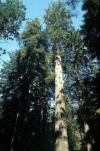
Humboldt Redwoods State Park is a state park of California, United States, containing Rockefeller Forest, the world's largest remaining contiguous old-growth forest of coast redwoods. It is located 30 miles (48 km) south of Eureka, California, near Weott in southern Humboldt County, within Northern California, named after the great German nineteenth-century scientist, Alexander von Humboldt. The park was established by the Save the Redwoods League in 1921 largely from lands purchased from the Pacific Lumber Company. Beginning with the dedication of the Raynal Bolling Memorial Grove, it has grown to become the third-largest park in the California State Park system, now containing 51,651 acres (20,902 ha) through acquisitions and gifts to the state.

Colorado National Monument is a National Park Service unit near the city of Grand Junction, Colorado. Sheer-walled canyons cut deep into sandstone and granite–gneiss–schist rock formations. This is an area of desert land high on the Colorado Plateau, with pinyon and juniper forests on the plateau. The park hosts a wide range of wildlife, including red-tailed hawks, golden eagles, ravens, jays, desert bighorn sheep, and coyotes. Activities include hiking, horseback riding, road bicycling, and scenic drives; a visitor center on the west side contains a natural history museum and gift shop. There are scenic views from trails, Rim Rock Drive, which winds along the plateau, and the campground. Nearby are the Book Cliffs and the largest flat-topped mountain in the world, the Grand Mesa.

Nelder Grove, located in the western Sierra Nevada within the Sierra National Forest in Madera County, California, is a Giant sequoia grove that was formerly known as Fresno Grove. The grove is a 1,540-acre (6.2 km2) tract containing 60 mature Giant Sequoia trees, the largest concentration of giant sequoias in the Sierra National Forest. The grove also contains several historical points of interest, including pioneer cabins, giant sequoia stumps left by 19th-century loggers, and the site where the Forest King exhibition tree was felled in 1870 for display.

ʻAkaka Falls State Park is a state park on Hawaiʻi Island, in the U.S. state of Hawaii. The park is about 11 miles (18 km) north of Hilo, west of Honomū off the Hawaii Belt Road at the end of Hawaii Route 220. It includes its namesake ʻAkaka Falls, a 442-foot (135 m) tall waterfall. ʻAkaka is named after Chief 'Akaka-o-ka-nī'au-oi'o-i-ka-wao, grandson of Kūlanikapele and Kīakalohia. The accessible portion of the park lies high on the right shoulder of the deep gorge into which the waterfall plunges, and the falls can be viewed from several points along a loop trail through the park. Also visible from this trail is Kahūnā Falls, a 300-foot (91 m) tall waterfall, and several smaller cascades.

Pukaskwa National Park is a national park located south of the town of Marathon, Ontario in the Thunder Bay District of northern Ontario, Canada. Established in 1978, Pukaskwa is known for its vistas of Lake Superior and boreal forests. The park covers an area of 1,878 square kilometres (725 sq mi), and protects a part of the longest undeveloped shoreline anywhere on the Great Lakes.

Montaña de Oro is a state park in Central Coastal California, six miles southwest of Morro Bay and two miles south of Los Osos.

The Big Morongo Canyon Preserve is a 31,000-acres (130 km2) native plants habitat and wildlife preserve located in the Little San Bernardino Mountains of the Transverse Ranges, in the transition zone between the higher Mojave Desert and lower elevation Colorado Desert section of the Sonoran Desert. Due to its location within this transition zone, the area is especially high in natural diversity. The natural spring fed desert oasis found here is one of the 10 largest Cottonwood and Willow riparian habitats in California. It is also identified by the Audubon Society as one of the most important avian habitat areas in California.

Mount Scenery is a dormant volcano in the Caribbean Netherlands. Its lava dome forms the summit of the Saba island stratovolcano. At an elevation of 870 m (2,854 ft), it is the highest point in both the Kingdom of the Netherlands, and, since the dissolution of the Netherlands Antilles on 10 October 2010, the highest point in the Netherlands proper.

Darwin Falls is a waterfall located on the western edge of Death Valley National Park near the settlement of Panamint Springs, California. Although there exists a similarly named Darwin Falls Wilderness adjacent to the falls, the falls themselves are located in and administered by Death Valley National Park and the National Park Service. There are several falls, but they are mainly divided into the upper and lower, with a small grotto in between. At a combined 80 feet (24 m), it is the highest waterfall in the park. The canyon is walled by dramatic plutonic rock.

Joshua Tree National Park is a national park of the United States in southeastern California, east of San Bernardino and Los Angeles and north of Palm Springs. It is named after the Joshua trees native to the Mojave Desert. Originally declared a national monument in 1936, Joshua Tree was redesignated as a national park in 1994 when the U.S. Congress passed the California Desert Protection Act. Encompassing a total of 795,156 acres – slightly larger than the state of Rhode Island – the park includes 429,690 acres of designated wilderness. Straddling San Bernardino and Riverside Counties, the park includes parts of two deserts, each an ecosystem whose characteristics are determined primarily by elevation: the higher Mojave Desert and the lower Colorado Desert. The Little San Bernardino Mountains traverse the southwest edge of the park.

Marquam Nature Park is a 203.5-acre (82.4 ha) park, located in the gulch northeast of Marquam hill in southwest Portland, Oregon, United States. The park was acquired by Portland Parks & Recreation in 1979. Marquam Nature Park is in Southwest Portland in the Tualatin Mountains, also known as the West Hills, and has several miles of hiking trails.

Ryan Mountain is a 5,456-foot-high (1,663 m) mountain in Joshua Tree National Park. The trail to the peak is a strenuous hike, ascending 1,050 feet (320 m) in 1.5 miles (2.4 km). Ryan Mountain is a popular attraction in the park, because it leads to panoramic views of Pinto Basin, Lost Horse Valley, Queen Valley, and Pleasant Valley. It is one of the locations in Joshua Tree that features abundant lichen populations. It is named after J.D. Ryan, a wealthy rancher and early mining operator in the park.

Lost Palms Oasis Trail is a 7.2-mile (11.6 km) day-hike trail located in the southernmost part of Joshua Tree National Park. The trail is generally completed in a loop. Known for the beautiful palm trees from which the trail gets its name, this hike is also known for its great bouldering, pools of water, and the ever-elusive "Victory Palms". Deemed by the National Park Service as a day-use-only area, this trail is also home to bighorn sheep who use the pools as their main source of water.

Hidden Valley is a self-guiding, one-mile loop trail that winds among massive boulders through what was believed to be a legendary cattle rustlers' hideout. It is one of the most popular and scenic hiking trails in Joshua Tree National Park. The area is also a popular rock-climbing area. Many visitors enjoy just watching the climbers in action.
Mount Tom is a small peak, standing at 1357 feet, located in the town of Woodstock, Vermont. It is a part of the Marsh-Billings-Rockefeller National Historical Park. The peak has a multitude of hiking, running, and Nordic skiing trails, and has many sites dedicated to the national park. Standing in the middle of Woodstock, Vermont, the peak also is host to many annual town events, including the Road to the Pogue Race. Visible from the top are sights such as the village of Woodstock, the sister peak of Mount Tom, the Ottauquechee River, Vermont Route 4A, and many neighboring mountains.
There are nine national parks located in the state of California managed by the National Park Service. National parks protect significant scenic areas and nature reserves, provide educational programs, community service opportunities, and are an important part of conservation efforts in the United States. There are several other locations inside of California managed by the National Park Service, but carry other designations such as National Monuments. Many of the national parks in California are also part of national forests and National Wildlife Refuges, and contain Native American Heritage Sites and National Monuments.
Pioneertown Mountains Preserve is a nature preserve owned and managed by The Wildlands Conservancy, a nonprofit land conservancy. Consisting of 25,500 acres (103 km2) of land in San Bernardino County, California, the preserve features geologically interesting mountain ranges and riparian zones. It is located in the Mojave Desert in the eastern San Bernardino Mountains. More preserves can be found in the list of preserves.
| | This California location article is a stub. You can help Wikipedia by expanding it. |