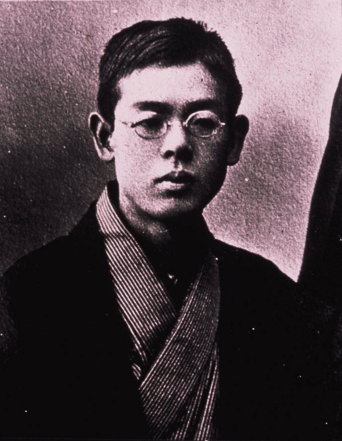
Rentarō Taki was a Japanese pianist and composer of the Meiji era.

The Ōsumi Peninsula projects south from the Japanese island of Kyūshū and includes the southernmost point on the island, Cape Sata. Its east coast lies on the Pacific Ocean, while to the west it faces the Satsuma Peninsula across Kagoshima Bay. Politically it is part of Kagoshima Prefecture. Lava erupted in 1914 by Sakurajima made a land connection with the northwest of the Ōsumi Peninsula.

The Satsuma Peninsula is a peninsula which projects south from the southwest part of Kyūshū Island, Japan. To the west lies the East China Sea, while to the east it faces the Ōsumi Peninsula across Kagoshima Bay. Politically, it belongs to Kagoshima Prefecture, and it includes the prefectural capital, Kagoshima City. Near the southern tip of the peninsula is the 924 metres (3,031 ft) Mount Kaimon (Kaimon-dake) and the hot springs of Ibusuki Onsen.

An ōnusa or simply nusa or Taima is a wooden wand traditionally used in Shinto purification rituals.
The Hyūga Nada is the part of the Pacific Ocean that lies off the eastern shore of the island of Kyushu, to the south-west of the island of Honshu, off the south coast of Japan. Its name is derived from the former province of Hyūga, which corresponded to the prefecture of Miyazaki before the Meiji Restoration. Also, earthquakes occur repeatedly in Hyuga Nada.
Minecart is a short story written by Ryūnosuke Akutagawa. It was published in 1922. It is a story about a young boy who experiences the adult world for a short amount of time. Many junior high school students in Japan study this short story in class.

The Abukuma Highlands or Abukuma Mountains is a highland area of Japan that extends from the southern part of Miyagi Prefecture to the eastern part of Fukushima Prefecture and then to the northern part of Ibaraki Prefecture. Most of the highlands belong to Fukushima Prefecture. The highest peak in the highlands is Mount Ōtakine (1,192m).
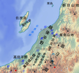
Echigo Plain or Niigata Plain is an alluvial plain that extends from central to northern Niigata Prefecture in Japan. The area of the plain is approximately 2000km2. It is the largest rice-growing area in Japan. The plain was formed by the Agano and Shinano rivers.

Tokachi Plain is a plain facing the Pacific Ocean, located in the southeastern part of Hokkaido. The area of the plain is approximately 3600km2.

Shikoku Mountains is a mountain range that runs from east to west in the central part of the Shikoku in Japan. The length of the mountain range is about 250km. The highest peak in the mountain range is Mount Ishizuchi.

Kyushu Mountains is a mountain range that runs from northeast to southwest in central Kyushu. The highest peak of the mountain range is Mount Sobo.

Tosa Bay is a bay north of the line connecting Cape Muroto and Cape Ashizuri in Kochi Prefecture, Japan. Tosa Bay is better fishing grounds in Japan, which is strongly affected by the Kuroshio Current.

Dewa Mountains is a mountain range that runs north and south on the west side of the Tohoku region of Japan. The mountain range spans Aomori, Akita, and Yamagata prefectures. The highest peak of the mountain range is Mount Chokai (2,236m).

Echigo Mountains is a mountain range that straddles Niigata, Fukushima, and Gunma prefectures in Japan.
Enshū Sea is the sea area from Cape Irōzaki in Shizuoka Prefecture to Cape Daiō in Mie Prefecture. It is also called Tōtōmi Sea or TenryūSea.

The Ane River is a river that flows through the northern part of Shiga Prefecture, Japan, entering Lake Biwa at the city of Nagahama.
Amakusa Nada is a sea area extending to the west of Shimoshima Island, Amakusa in Japan.

Ojiya-chijimi is a Hemp that is woven mainly in Ojiya, Niigata in Japan. It is a fabric using Ramie. It was designated as an Important Intangible Cultural Property in 1955, and was registered as a Intangible cultural heritage along with Echigo-jofu in 2009.
Hisakatsu Yabe was a Japanese paleontologist and geologist. He is from Tokyo and is a graduate of the University of Tokyo. He was an emeritus professor at Tohoku University. Yabe contributed to the development of geology in Japan. In 1918, He advocated Itoigawa-Shizuoka Tectonic Line.

Hōgetsu Shimamura was a Japanese critic, novelist and leader of Shingeki. His real name is Takitaro (滝太郎). He was born in Shimane Prefecture. He graduated from Tōkyō Senmon Gakkō. In 1902 he studied abroad in the United Kingdom and Germany. In 1906, he founded the Bungei Kyōkai with Tsubouchi Shoyo. He presided over Waseda Bungaku and was active in the naturalistic literary movement. In 1913, he established the Geijutsu-za theatre troupe with Sumako Matsui. His main works are Shinbijigaku (新美辞学), Kindai Bungei no Kenkyu (近代文芸之研究) and so on.
