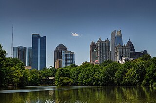
Fulton County is a county in the north-central portion of the U.S. state of Georgia. As of the 2020 United States census, the population was 1,066,710, making it the state's most populous county. Its county seat and most populous city is Atlanta, the state capital. About 90% of the city of Atlanta is within Fulton County; the remaining portion is in DeKalb County. Fulton County is part of the Atlanta–Sandy Springs–Roswell metropolitan statistical area.

Fayette County is a county located in the north central portion of the U.S. state of Georgia. As of the 2020 census, the population was 119,194, an increase from 106,567 in 2010. Fayette County was established in 1821. The county seat, Fayetteville, was established in 1823. Much of Fayette County is bordered on the east side by the Flint River.

Chamblee is a city in northern DeKalb County, Georgia, United States, northeast of Atlanta. The population was 30,164 as of the 2020 census.

The history of Atlanta dates back to 1836, when Georgia decided to build a railroad to the U.S. Midwest and a location was chosen to be the line's terminus. The stake marking the founding of "Terminus" was driven into the ground in 1837. In 1839, homes and a store were built there and the settlement grew. Between 1845 and 1854, rail lines arrived from four different directions, and the rapidly growing town quickly became the rail hub for the entire Southern United States. During the American Civil War, Atlanta, as a distribution hub, became the target of a major Union campaign, and in 1864, Union William Sherman's troops set on fire and destroyed the city's assets and buildings, save churches and hospitals. After the war, the population grew rapidly, as did manufacturing, while the city retained its role as a rail hub. Coca-Cola was launched here in 1886 and grew into an Atlanta-based world empire. Electric streetcars arrived in 1889, and the city added new "streetcar suburbs".

Midtown Atlanta, or Midtown, is a high-density commercial and residential neighborhood of Atlanta, Georgia. The exact geographical extent of the area is ill-defined due to differing definitions used by the city, residents, and local business groups. However, the commercial core of the area is anchored by a series of high-rise office buildings, condominiums, hotels, and high-end retail along Peachtree Street between North Avenue and 17th Street. Midtown, situated between Downtown to the south and Buckhead to the north, is the second-largest business district in Metro Atlanta. In 2011, Midtown had a resident population of 41,681 and a business population of 81,418.

Buckhead is the uptown commercial and residential district of the city of Atlanta, Georgia, comprising approximately the northernmost fifth of the city. Buckhead is the third largest business district within the Atlanta city limits, behind Downtown and Midtown, and a major commercial and financial center of the Southern U.S.

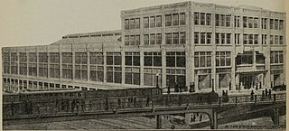
The architecture of Atlanta is marked by a confluence of classical, modernist, post-modernist, and contemporary architectural styles. Due to the Battle of Atlanta and the subsequent fire in 1864, the city's architecture retains almost no traces of its Antebellum past. Instead, Atlanta's status as a largely post-modern American city is reflected in its architecture, as the city has often been the earliest, if not the first, to showcase new architectural concepts. However, Atlanta's embrace of modernism has translated into an ambivalence toward architectural preservation, resulting in the destruction of architectural masterpieces, including the Commercial-style Equitable Building, the Beaux-Arts style Terminal Station, and the Classical Carnegie Library. The city's cultural icon, the Neo-Moorish Fox Theatre, would have met the same fate had it not been for a grassroots effort to save it in the mid-1970s.
The neighborhood planning unit (NPU) is a community-scale governmental structure used in the City of Atlanta, Georgia.
Atlanta's Third Ward was defined in 1880 as the area bounded on the North by Georgia Railroad, West by Butler & McDonough Streets, South and East by the city limits
From its incorporation in 1847, the municipal boundaries of Atlanta, Georgia, United States, were extended repeatedly from a small area around its railroad station to today's city covering 131.7 square miles (341 km2).

Brookhaven is a city in the northeastern suburbs of Atlanta that is located in western DeKalb County, Georgia, United States, directly northeast of Atlanta. On July 31, 2012, Brookhaven was approved in a referendum to become DeKalb County's 11th city. Incorporation officially took place on December 17, 2012, on which date municipal operations commenced. With a population of around 55,366 as of 2021, it is the largest city in DeKalb County. The new city stretches over 12 square miles (31 km2).
A city in the context of local government in New Jersey refers to one of five types and one of eleven forms of municipal government. Despite the widely held perception of a city as a large, urban area, cities in New Jersey have a confused history as a form of government and vary in size from large, densely populated areas to much smaller hamlets.

The city government of Atlanta, Georgia, in the United States is composed of a mayor and a body of one councilman from each of 12 districts, a City Council President, and 3 other at-large councilmen:

The Great Atlanta Fire of 1917 began just after noon on 21 May 1917 in the Old Fourth Ward of Atlanta, Georgia. It is unclear just how the fire started, but it was fueled by hot temperatures and strong winds which propelled the fire. The fire, which burned for nearly 10 hours, destroyed 300 acres (120 ha) and 1,900 structures displacing over 10,000 people. Damages were estimated at $5 million,.

The Old Fourth Ward, often abbreviated O4W, is an intown neighborhood on the eastside of Atlanta, Georgia, United States. The neighborhood is best known as the location of the Martin Luther King Jr. historic site.

Ponce de Leon Avenue, often simply called Ponce, provides a link between Atlanta, Decatur, Clarkston, and Stone Mountain, Georgia. It was named for Ponce de Leon Springs, in turn from explorer Juan Ponce de León, but is not pronounced as in Spanish. Several grand and historic buildings are located on the avenue.
Atlanta's Fifth Ward encompassed mainly what is now the part of downtown and midtown between the west side of Peachtree and the Western and Atlantic Railroad.

The City of London is divided into 25 wards. The city is the historic core of the much wider metropolis of Greater London, with an ancient and sui generis form of local government, which avoided the many local government reforms elsewhere in the country in the 19th and 20th centuries. Unlike other modern English local authorities, the City of London Corporation has two council bodies: the now largely ceremonial Court of Aldermen, and the Court of Common Council.

The Peachtree Arcade was a shopping arcade in downtown Atlanta, Georgia, United States. The building, modeled after the Arcade in Cleveland, was designed by Atlanta-based architect A. Ten Eyck Brown and was located between Peachtree Street and Broad Street near Five Points. Construction began in 1917 and was completed the following year. Located in the city's central business district, it was very popular with citizens, functioning as an unofficial "civic center" for the city. However, by the 1960s, the arcade was facing increased competition from shopping malls located in Atlanta's suburbs, and in 1964, the building was demolished to make way for the First National Bank Building, a skyscraper that, at the time of its construction, was the tallest building in both Atlanta and the southeastern United States. In 1993, the American Institute of Architects named the building as one of Atlanta's most notable landmarks to have been destroyed.


