
Blackfriars, Gloucester, England, founded about 1239, is one of the most complete surviving Dominican black friaries in England. Now owned by English Heritage and restored in 1960, it is currently leased to Gloucester City Council and used for weddings, concerts, exhibitions, guided tours, filming, educational events and private hires. The former church, since converted into a house, is a Grade I listed building.

Oram's Arbour was an enclosed settlement (oppidum) during the Iron Age, in what is now Winchester, England. Limited dating evidence suggests the enclosure was dug in the early-mid first century BC. The town wall of the Roman civitas capital of Venta Belgarum which succeeded the Iron Age settlement cut across its eastern end.

The Cardiff Centenary Walk is a tourist walkway through Cardiff city centre in Wales. Established as part of Cardiff's centennial celebrations to mark 100 years of city status in 2005, it has 41 points of interest, either Cardiff landmarks or significant historic sites. The route is marked by waymarkers on the pavement, which also direct pedestrians to the next waymarker. The whole walk is 3.6 kilometres (2.2 mi) long running around Cardiff in a clockwise direction, starting and finishing at the Cardiff Visitor Centre at the Old Library.
Donnington Friary was a friary of crouched friars at Donnington in the English county of Berkshire. At the time of suppression the establishment was recorded as Trinitarian, but this was later corrected to Crossed Friars. This was possibly a ploy by the two brothers in occupation at the time in order to ensure their pension.
Eremites Friary was a friary in Bristol, England. The Brothers Eremites of St. Augustine kept a small convent near Temple Gate, founded by Sir Simon and Sir William Montacute in 1320. No trace of it remains today.
Gillingham Friary was possibly a Dominican friary in the town of Gillingham, Dorset, England.
Colchester Crutched Friary was a friary in Colchester, in the county of Essex, England. The house was founded in 1235, the friary was dissolved in 1538 and the site was discovered in 1928 when pottery was found when 44 Crouch Street was being demolished.
Wotton under Edge Friary was a friary of the Crutched Friars in Wotton-under-Edge, Gloucestershire, England.

Greyfriars, Gloucester, England, was a medieval monastic house founded about 1231.

Whitefriars, also known as the White Friars or The College of Carmelites, Gloucester, England, was a Carmelite friary of which nothing now survives.
The Carmelite Friary, Winchester was a friary in Hampshire, England. It was founded in 1278 and suppressed in the early sixteenth century.
The Dominican Friary, Winchester, otherwise Winchester Blackfriars, was a priory of the Dominican Order in Winchester, Hampshire, England. It was founded between 1231 and 1234, one of the earliest Dominican foundations in England.
Salisbury Black Friary was a friary in Wiltshire, England, in existence from 1281 to 1538.
Salisbury Grey Friary was a friary in Wiltshire, England between the 1230s and 1538.
Win FM, the on-air name of Winchester Independent Radio, was an Independent Local Radio station for Winchester, in Hampshire, England, and surrounding areas. After two one-month trial broadcasts in 1996 and 1997 it won a permanent licence and began to broadcast on 3 October 1999. It closed on 2 October 2007.

Friary Park is a 9-hectare (22-acre) formal Edwardian park in Friern Barnet in the London Borough of Barnet. The park opened to the public in 1910, and the facilities include a cafe, playground and skatepark. It is a Site of Local Importance for Nature Conservation, and contains three redwood trees and a small stream. It is next to North Middlesex Golf Course, which contains the North Middlesex Golf Course Ponds nature reserve; this is not open to the public.

The Black Friar is a Grade II* listed public house on Queen Victoria Street in Blackfriars, London.

The Winchester is a public house in Highgate, London. It was built in 1881 as the Winchester Tavern, and later became the Winchester Hall Hotel. The name derives from Winchester Hall, a nearby late 17th-century mansion. The pub has featured on the Campaign for Real Ale's National Inventory of Historic Pub Interiors.

Hampshire Archives and Local Studies holds the archives for the county of Hampshire. The archives are located in Sussex Street, Winchester, and are run by Hampshire County Council.
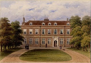
Winchester House, demolished, housed the Bishops of Winchester from 1664 to the early 19th century when in London. Their diocese for this purpose had bought the 17th-century part of Chelsea Place from Charles Cheyne in 1664. It replaced in function the shell remnants of Winchester Palace on the South Bank, Southwark left by the Wars of the Three Kingdoms. In 1821, after the house fell into disrepair, the bishop gained an Act that allowed the sale of the house and its ground of 2.5 acres to the trustees of the Cadogan Estate. In 1825, the trustees obtained a further Act to demolish the property and build new houses on the site. Demolition was complete by 1836, but the site was still vacant in 1847. By 1850, there were ten houses at the northern end, and four at the southern by 1851. The area is now known as Oakley Street.