Franklin Sound

Last updated

Franklin Sound south of Flinders Island. Furneaux Group Map.svg
Franklin Sound south of Flinders Island.

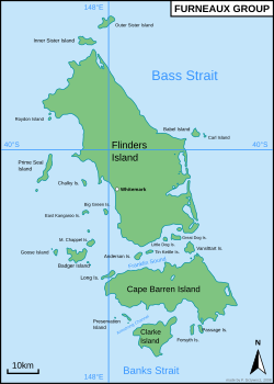
Franklin Sound is a narrow waterway between the two largest islands, Flinders Island and Cape Barren Island in the Furneaux Group, at the southeastern end of Bass Strait, between Victoria and Tasmania, Australia.

Named after British explorer and Lieutenant-Governor of Van Diemen's Land (1836-1843), Sir John Franklin (1786-1847).

Numerous sandbanks and small islands obstruct the sound and the tidal stream runs at 2 to 3 knots.

Related Research Articles

The Neyyar Wildlife Sanctuary in the southern state of Kerala in India is spread over the southeast corner of the Western Ghats, and covers a total area of 128 km2 (49 sq mi). It is located between 77° 8’ to 77° 17’ east longitude and 8° 29’ to 8° 37’ north latitude, central location 8°33′N77°12.5′E. Although it was declared as a sanctuary in 1958, not much was done about wildlife conservation, until 1985, when a separate wildlife wing was set up and as a result, conservation efforts have gathered momentum. It is part of the Agasthyamala Biosphere Reserve.

<span class="mw-page-title-main">Little Green Island</span> Island in Tasmania, Australia

Little Green Island is a granite island, with an area of 87 hectares, in south-eastern Australia. It is part of Tasmania’s Great Dog Island Group, lying in eastern Bass Strait between Flinders and Cape Barren Islands in the Furneaux Group. It is partly a conservation area, and partly private property, used for grazing livestock. The island has been degraded by repeated burning and grazing. Commercial muttonbirding took place until 1957, and recreational muttonbirding since then. The island is part of the Franklin Sound Islands Important Bird Area, identified as such by BirdLife International because it holds over 1% of the world populations of six bird species.

The Oyster Rocks are a close pair of small granite islands, with a combined area of about 6 ha, in south-eastern Australia. They are part of Tasmania’s Tin Kettle Island Group, lying in eastern Bass Strait between Flinders and Cape Barren Islands in the Furneaux Group. They are a conservation area. The islands are part of the Franklin Sound Islands Important Bird Area, identified as such by BirdLife International because it holds over 1% of the world populations of six bird species.

<span class="mw-page-title-main">Franklin's lost expedition</span> British expedition of Arctic exploration

Franklin's lost expedition was a failed British voyage of Arctic exploration led by Captain Sir John Franklin that departed England in 1845 aboard two ships, HMS Erebus and HMS Terror, and was assigned to traverse the last unnavigated sections of the Northwest Passage in the Canadian Arctic and to record magnetic data to help determine whether a better understanding could aid navigation. The expedition met with disaster after both ships and their crews, a total of 129 officers and men, became icebound in Victoria Strait near King William Island in what is today the Canadian territory of Nunavut. After being icebound for more than a year Erebus and Terror were abandoned in April 1848, by which point Franklin and nearly two dozen others had died. The survivors, now led by Franklin's second-in-command, Francis Crozier, and Erebus's captain, James Fitzjames, set out for the Canadian mainland and disappeared, presumably having perished.

<span class="mw-page-title-main">Little Anderson Island</span> Island in Tasmania, Australia

Little Anderson Island is an island, with an area of 13 ha, in south-eastern Australia. It is part of Tasmania’s Tin Kettle Island Group, lying in eastern Bass Strait between Flinders and Cape Barren Islands in the Furneaux Group. The island is joined at low tide to nearby Anderson and Tin Kettle Islands by extensive intertidal mudflats. The island is part of the Franklin Sound Islands Important Bird Area, identified as such by BirdLife International because it holds over 1% of the world populations of six bird species.

Mid Woody Islet is a small island, with an area of 0.66 ha, in south-eastern Australia. It is part of Tasmania’s Tin Kettle Island Group, lying in eastern Bass Strait between Flinders and Cape Barren Islands in the Furneaux Group. The island is joined at low tide to nearby Anderson, Little Anderson and Tin Kettle Islands by extensive intertidal mudflats. The island is part of the Franklin Sound Islands Important Bird Area, identified as such by BirdLife International because it holds over 1% of the world populations of six bird species.

<span class="mw-page-title-main">Tin Kettle Island</span> Island in Tasmania, Australia

Tin Kettle Island is a long, sandy island, with an area of 176 ha, in south-eastern Australia. It is part of Tasmania’s Tin Kettle Island Group, lying in eastern Bass Strait between Flinders and Cape Barren Islands in the Furneaux Group. The island is joined at low tide to nearby Anderson and Little Andersons by extensive intertidal mudflats. The island is farmed, mainly cattle grazing. The island is part of the Franklin Sound Islands Important Bird Area, identified as such by BirdLife International because it holds over 1% of the world populations of six bird species.

<span class="mw-page-title-main">Neds Reef</span>

Neds Reef is a group of three small granite islets, joined at low tide by extensive mudflats, with a combined area of about 3 ha, in south-eastern Australia. They are part of Tasmania’s Tin Kettle Island Group, lying in eastern Bass Strait between Flinders and Cape Barren Islands in the Furneaux Group. The reef is part of the Franklin Sound Islands Important Bird Area, identified as such by BirdLife International because it holds over 1% of the world populations of six bird species.

<span class="mw-page-title-main">Little Dog Island</span> Island in Tasmania, Australia

Little Dog Island is a square, flat granite island, with an area of 83 ha, in south-eastern Australia. It is part of Tasmania’s Great Dog Island Group, lying in eastern Bass Strait between Flinders and Cape Barren Islands in the Furneaux Group. It is a game reserve. It was previously grazed, a usage now ceased. The island is part of the Franklin Sound Islands Important Bird Area, identified as such by BirdLife International because it holds over 1% of the world populations of six bird species.

<span class="mw-page-title-main">Spences Reefs</span> Islets in Tasmania, Australia

Spences Reefs is a pair of reefs consisting of two islets, with a combined area of 0.65 ha, in Tasmania, Australia.

Samphire Island is a small shell-grit island, with an area of 3.3 ha, in south-eastern Australia. It is part of Tasmania’s Great Dog Island Group, lying in eastern Bass Strait between Flinders and Cape Barren Islands in the Furneaux Group. It is surrounded by mudflats at low tide.

<span class="mw-page-title-main">Fisher Island (Tasmania)</span> Island in Tasmania, Australia

Fisher Island is a small granite island, with an area of 0.9 ha, in south-eastern Australia. It is part of Tasmania’s Great Dog Island Group, lying in eastern Bass Strait between Flinders and Cape Barren Islands in the Furneaux Group. It is the site of a long-term, ongoing study of short-tailed shearwaters.

<span class="mw-page-title-main">Vansittart Island</span> Island in Tasmania, Australia

Vansittart Island, also known as Gun Carriage Island, is a granite island with an area of 800 hectares. The island is part of Tasmania's Vansittart Island Group, lying in eastern Bass Strait between Flinders and Cape Barren Islands in the Furneaux Group.

Ram Island is a small mudstone and dolerite island, with an area of 1 ha, in south-eastern Australia. It is part of Tasmania’s Vansittart Island Group, lying in eastern Bass Strait between Flinders and Cape Barren Islands in the Furneaux Group. It is privately owned.

Puncheon Island is an island, with an area of 17.56 ha, in south-eastern Australia. It is part of Tasmania’s Vansittart Island Group, lying in eastern Bass Strait between Flinders and Cape Barren Islands in the Furneaux Group. It is surrounded by mudflats. It is privately owned and used for farming. It has been extensively burnt and grazed.

<span class="mw-page-title-main">Pelican Island (Tasmania)</span> Island in Tasmania, Australia

Pelican Island is an island, with an area of 6.8 ha including an associated reef joined to it at low tide, in south-eastern Australia. It is part of Tasmania’s Vansittart Island Group, lying in eastern Bass Strait between Flinders and Cape Barren Islands in the Furneaux Group. Until 1984 it was leased for grazing. The island is part of the Franklin Sound Islands Important Bird Area, identified as such by BirdLife International because it holds over 1% of the world populations of six bird species.

<span class="mw-page-title-main">Franklin Sound Islands Important Bird Area</span> Important Bird Area in Tasmania, Australia

The Franklin Sound Islands Important Bird Area comprises several small islands, with a collective total area of 1725 ha, lying in Franklin Sound between the much larger Flinders Island to the north and Cape Barren Island to the south, in the Furneaux Group of Tasmania, Australia.

<span class="mw-page-title-main">Forsyth Island (New Zealand)</span>

Forsyth Island lies in the outer Marlborough Sounds of New Zealand's South Island and is separated from the mainland by the 300m wide Allen Strait. The island comprises a mixture of farm land and native bush on hills rising to over 350 metres (1,148 ft) with views into the Marlborough Sounds and east towards the North Island.

<span class="mw-page-title-main">Thomas Abernethy (explorer)</span> Scottish seafarer and polar explorer (1803–1860)

Thomas Abernethy was a Scottish seafarer, gunner in the Royal Navy, and polar explorer. Because he was neither an officer nor a gentleman, he was little mentioned in the books written by the leaders of the expeditions he went on, but was praised in what was written. In 1857, he was awarded the Arctic Medal for his service as an able seaman on the 1824–25 voyage of HMS Hecla, the first of his five expeditions for which participants were eligible for the award. He was in parties that, for their time, reached the furthest north, the furthest south (twice), and the nearest to the South Magnetic Pole. In 1831, along with James Clark Ross's team of six, Abernethy was in the first party ever to reach the North Magnetic Pole.

<span class="mw-page-title-main">Sursaigh</span> Island off North Uist in the Sound of Harris, Scotland

Sursaigh is an island off North Uist in the Sound of Harris, Scotland. It lies 8 kilometres (5.0 mi) northeast of the village of Lochmaddy and there are numerous nearby islands including Stromay, Sgarabhaigh and Tahay.

References

    Coordinates: 40°17.5′S148°12.5′E / 40.2917°S 148.2083°E / -40.2917; 148.2083