
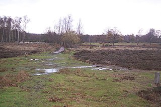
Bovey Heath is a 32 hectare (50 acre) area of heathland between Bovey Tracey and Heathfield in south Devon, England.

Cannop Ponds are two large ponds, just north of Parkend in the Forest of Dean, Gloucestershire, England. The ponds, and surrounding area, are a popular tourist destination.
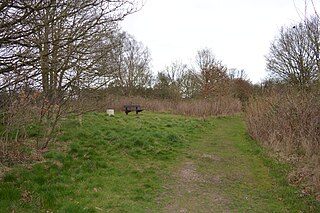
Hothfield Common is a 56.5-hectare (140-acre) biological Site of Special Scientific Interest north-east of Ashford in Kent. It is also a Local Nature Reserve, and is part of the 86-hectare (210-acre) Hothfield Heathlands nature reserve owned by Ashford Borough Council and managed by Kent Wildlife Trust.
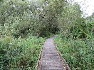
Winnall Moors is a 64-hectare (160-acre) nature reserve in Winchester in Hampshire. It is managed by the Hampshire and Isle of Wight Wildlife Trust.

Arkley Lane and Pastures is a 50-hectare (120-acre) Site of Borough Importance for Nature Conservation, Grade II, in Arkley in the London Borough of Barnet. Arkley Lane, off Barnet Road, is an old drovers' road. Located on the Barnet Plateau, it is now a quiet country lane with a traditional bank and ditch. The thick hedges are composed of beech and hornbeam, ash, field maple and magnificent old pedunculate oaks.

Saffron Green Meadows or Saffron Green Pasture is an area of public open space and farmland north of Arkley in Hertsmere, Hertfordshire, England. It is owned and managed by Hertfordshire County Council, and is part of the Watling Chase Community Forest and the London Green Belt.

Frays Farm Meadows is a 28.2-hectare (70-acre) biological Site of Special Scientific Interest near Denham in the London Borough of Hillingdon. It was notified as an SSSI in 1981, and has been managed by the London Wildlife Trust on behalf of Hillingdon Council since 1999. It is part of the Colne Valley Regional Park.
Ridley Bottom is a 1.1-hectare (2.7-acre) nature reserve in Gloucestershire. The site is listed in the 'Forest of Dean Local Plan Review' as a Key Wildlife Site (KWS).

Lavender Pond is a 2.5 acre local nature reserve in Rotherhithe in the London Borough of Southwark. It is owned by Southwark Council and managed by The Conservation Volunteers. The nature reserve has an area of woodland as well as the pond.

Ten Acre Wood is a Local Nature Reserve (LNR) in Yeading in the London Borough of Hillingdon, which is owned by Hillingdon Council and managed by the London Wildlife Trust (LWT). It is also part of the Yeading Brook Meadows Site of Metropolitan Importance for Nature Conservation (SINC), which includes two neighbouring LNRs managed by the LWT, Gutteridge Wood and Meadows and Yeading Brook Meadows LNR.

Yeading Brook Meadows is a 17 hectare Local Nature Reserve (LNR) in Yeading in the London Borough of Hillingdon. It is owned by Hillingdon Council and managed by the London Wildlife Trust (LWT). In the north it adjoins Ten Acre Wood across the Golden Bridge and Charville Lane; it then stretches south along the banks of the Yeading Brook to Yeading Lane. The reserve is also part of the Yeading Brook Meadows Site of Metropolitan Importance for Nature Conservation, which includes two neighbouring LNRs managed by the London Wildlife Trust, Ten Acre Wood and Gutteridge Wood and Meadows.

Oughtonhead Common is a 17.4 hectare Local Nature Reserve in the Westmill district of Hitchin, Hertfordshire. It is owned and managed by North Hertfordshire District Council. and home to the Oughtonhead Common nature reserve.
Fisher's Field is a 1.8 hectare Local Nature Reserve (LNR) in Bushey in Hertfordshire. It is owned and managed by Hertsmere Borough Council.

Brush Hill is a 14.7 hectares Local Nature Reserve east of Princes Risborough in Buckinghamshire. It has been managed since 2013 by the Chiltern Society, and it is part of the Chilterns Area of Outstanding Natural Beauty.

Hosehill Lake is a 23.6-hectare (58-acre) Local Nature Reserve west of Reading in Berkshire. It is owned by West Berkshire Council and managed by the Berkshire, Buckinghamshire and Oxfordshire Wildlife Trust.

Foxes Cross Bottom is a 4-hectare (9.9-acre) Local Nature Reserve north-west of Whitstable in Kent. It is owned and managed by Canterbury City Council.

Rodborough Common is a 62.2-hectare (154-acre) Local Nature Reserve west of Milford in Surrey. It is owned by Surrey County Council and managed by Surrey Wildlife Trust.

Cooksbridge Meadow is a 9-hectare (22-acre) nature reserve south of Fernhurst in Sussex. It is managed by the Sussex Wildlife Trust.

Port Meadow with Wolvercote Common and Green is a 167.1-hectare (413-acre) biological Site of Special Scientific Interest in Oxford in Oxfordshire. It is a Nature Conservation Review site, Grade I, and part of Oxford Meadows Special Area of Conservation. The remains of Godstow Abbey, which is a Scheduled Monument, are in the north of the site.

Greywell Fen is a 38-hectare (94-acre) biological Site of Special Scientific Interest in Greywell in Hampshire. It is a Nature Conservation Review site, Grade 2, and an area of 13 hectares is a nature reserve called Greywell Moors, which is managed by the Hampshire and Isle of Wight Wildlife Trust.
