French Pass

Last updated

New Zealand relief map.jpg
Red pog.svg
French Pass
French Pass has the fastest tidal flows in New Zealand
FrenchPassFromTheSW.JPG

French Pass (Māori : Te Aumiti; officially Te Aumiti / French Pass) is a narrow and treacherous stretch of water that separates D'Urville Island, at the north end of the South Island of New Zealand, from the mainland coast. At one end is Tasman Bay, and at the other end the outer Pelorus Sound / Te Hoiere leads out to Cook Strait.

Contents

French Pass has the fastest tidal flows in New Zealand, reaching 8 knots (4 m/s). [1] When the tide changes, the current can be strong enough to stun fish. [2]

The local tribes are Ngāti Koata and Ngāti Kuia.

History

In the oral tradition of some Māori tribes, Te Aumiti (French Pass) is the resting place of Kupe's pet king shag, called Te Kawau-a-Toru. Kupe was a pioneer Polynesian navigator who discovered Cook Strait in his canoe. While he was exploring Cook Strait, Kupe was attacked by a giant octopus. In the furious battle to kill the octopus, the coast was gouged into the convoluted shapes that today make up the Sounds. Kupe's loyal shag then led Kupe to the French Pass passage, and explored the area on Kupe's behalf. Te Kawau-a-Toru had a huge wingspan, and was reputed to be a sacred bird with "the eye of the ancestor", insight into ancient knowledge. [3] However, while testing the channel to see if it was safe for Kupe's canoe, Te Kawau-a-Toru got caught in the tidal rip, broke a wing and drowned. The broken reef adjacent to the channel is Kupe's loyal bird turned to stone – Te Aumiti a te Kawau-a-Toru (the currents that swallowed Toru's shag). A nearby rocky point where a lighthouse now stands is the bird's petrified bones. [4]

The first recorded European navigation of the pass occurred in 1827. Admiral Jules Dumont d'Urville navigated the pass during his second voyage to New Zealand, in the French Navy corvette Astrolabe. Approaching the narrowest part of the pass, the vessel swung sideward and did not respond to steerage. The corvette struck rocks twice, and was then washed over the reef and into Admiralty Bay. The high energy and complexity of the location was summed up by d'Urville suggesting that no one should attempt to navigate French Pass except in extreme emergency. [5]

In 1888, a Risso's dolphin appeared in the area. For the next 24 years, this dolphin accompanied boats to and from French Pass. He became famous as Pelorus Jack and was the first dolphin in the world to receive the protection of the law. Pelorus Jack stayed in the Pelorus Sounds, and did not navigate the pass into Tasman Bay. He would meet boats as they came out of the pass, riding their bow waves for 8 kilometres (5.0 mi) to Pelorus Sound. Then he would join boats returning to Nelson at the entrance to Pelorus Sound / Te Hoiere and escort them back to the pass. Pelorus Jack was last seen in April 1912. The lightkeeper at French Pass claimed he found the body of Pelorus Jack decomposing on the shore. [6]

In August 2014, the name of French Pass was officially altered to Te Aumiti / French Pass. [7]

Tidal flows

External images
Searchtool.svg Painting of a King shag
Searchtool.svg Painting of the Astrolabe in French Pass
Searchtool.svg Photo of the French Pass in full flow
Searchtool.svg Google image

The pass is 500 metres (1,600 ft) across, but the main navigation channel (the "throat" or "narrows") contracts down to only 100 metres (330 ft) with a 20-metre (66 ft) deep shoaling region. Most of the rest of the pass is broken reef. [8]

On one side is Cook Strait with a tidal range up to 2 metres (6.6 ft), and on the other side is Tasman Bay with a tidal range up to 4 metres (13 ft). [9] This can result in substantial pressure gradients across the pass, complicated by a phase or time difference of about 25 minutes between the high tides on either side. Peak flow in the throat of the pass is around 4 metres per second (13 ft/s). [10]

Near to the pass are deep holes where strong vertical flows can occur. [11] In 2000, student divers taking part in a drift dive during the local ebb flow were separated from their surface float and caught in a whirlpool. This dragged them into "Jacob's Hole", a 68-metre (223 ft) [12] deep depression south west of the pass. The depth of this descent resulted in multiple fatalities. The group appears to have been drawn deep into the hole and then returned to the surface again. A dive computer record of one of the survivors show a depth of up to 89-metre (292 ft). According to the coroner's report, the accident occurred on a falling tide, so the current was flowing from the south west to the north east. [13] [14]

French Pass / Anaru

French Pass / Anaru is an unofficial name for the settlement south of French Pass, which has been in use since at least 1980. [15] It was formerly Anaru. [16] There is a short walk to a lookout overlooking the channel [17] and a campground, with a boat ramp and jetty. The road to French Pass / Anaru is about 70 km (43 mi) from SH6, [18] much of it unsealed and with sharp bends. [19]

Notes

  1. Stevens et al. (2008)
  2. Craig Stevens and Stephen Chiswell. Ocean currents and tides: Tides Te Ara - the Encyclopedia of New Zealand, updated 21 September 2007.
  3. King shag New Zealand Birds. Retrieved 2 March 2009.
  4. Te Ahukaramū Charles Royal. First peoples in Māori tradition: Te Aumiti (French Pass) Te Ara - the Encyclopedia of New Zealand, updated 28 October 2008.
  5. Baldwin 1979, p. 164
  6. Gerard Hutching. Dolphins: The story of Pelorus Jack Te Ara - the Encyclopedia of New Zealand, updated 22 October 2008
  7. "NZGB decisions". Land Information New Zealand. August 2014. Archived from the original on 21 November 2015. Retrieved 7 November 2015.
  8. "Chart of French Pass". Archived from the original on 16 October 2008. Retrieved 28 February 2009.
  9. Heath RA (1978) Semidiurnal tides in Cook Strait. New Zealand Journal of Marine and Freshwater Research 12: 87–97.
  10. Stevens et al. (2007)
  11. Stevens et al. (2007)
  12. GPS Nautical Charts, accessed 18 May 2019
  13. Smith IR (2003) Coroners Report Archived 2009-03-04 at the Wayback Machine Nelson District. Accessed 5 December 2008.
  14. McGeogh G and Davis FM (2000) "Analysis of a complex recreational scuba diving accident: French Pass, New Zealand". Diving and Hyperbaric Medicine, 39: 1.
  15. "NZGB Gazetteer | linz.govt.nz". gazetteer.linz.govt.nz. Retrieved 9 December 2021.
  16. "Te Aumiti/French Pass Heritage". Marlborough NZ. Retrieved 9 December 2021.
  17. "French Pass Lookout Track". www.doc.govt.nz. Retrieved 9 December 2021.
  18. "French Pass Campsite". www.doc.govt.nz. Retrieved 9 December 2021.
  19. "Te Aumiti (French Pass), Marlborough". NZ Topo Map. Retrieved 9 December 2021.

Related Research Articles

<span class="mw-page-title-main">Arapaoa Island</span> Island in Marlborough Sounds, New Zealand

Arapaoa Island is the second-largest island in the Marlborough Sounds, at the north-east tip of the South Island of New Zealand. The island has a land area of 75 km2. Queen Charlotte Sound defines its western side, while to the south lies Tory Channel, which is on the sea route between Wellington in the North Island to Picton. Cook Strait's narrowest point is between Arapaoa Island's Perano Head and Cape Terawhiti in the North Island.

<span class="mw-page-title-main">D'Urville Island</span> Landmass off South Island in the South Pacific

D'Urville Island, Māori name Rangitoto ki te Tonga, is the largest island in the Marlborough Sounds, on the northern coast of the South Island of New Zealand. It was named after the French explorer Jules Dumont d'Urville. With an area of approximately 150 square kilometres (58 sq mi), it is the eighth-largest island of New Zealand, and has around 52 permanent residents. The local authority is the Marlborough District Council.

<span class="mw-page-title-main">Cook Strait</span> Strait between the North and South Islands of New Zealand

Cook Strait separates the North and South Islands of New Zealand. The strait connects the Tasman Sea on the northwest with the South Pacific Ocean on the southeast. It is 22 kilometres (14 mi) wide at its narrowest point, and is considered one of the most dangerous and unpredictable waters in the world. Regular ferry services run across the strait between Picton in the Marlborough Sounds and Wellington.

<span class="mw-page-title-main">Marlborough Sounds</span> Series of flooded valleys at the northern end of New Zealands South Island

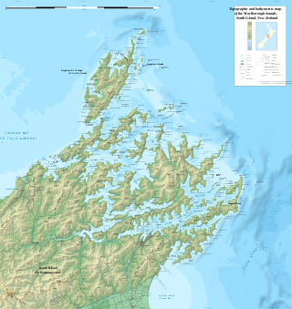
The Marlborough Sounds are an extensive network of sea-drowned valleys at the northern end of the South Island of New Zealand. The Marlborough Sounds were created by a combination of land subsidence and rising sea levels. According to Māori mythology, the sounds are the prows of the many sunken waka of Aoraki.

<span class="mw-page-title-main">Tory Channel</span> Channel in New Zealand

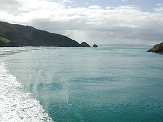
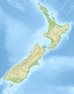
Tory Channel is one of the drowned valleys that form the Marlborough Sounds in New Zealand. Inter-island ferries normally use it as the principal channel between Cook Strait and the Marlborough Sounds.

<span class="mw-page-title-main">Lake Wakatipu</span> Lake in the South Island of New Zealand

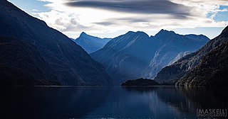
Lake Wakatipu is an inland lake in the South Island of New Zealand. It is in the southwest corner of the Otago region, near its boundary with Southland. Lake Wakatipu comes from the original Māori name Whakatipu wai-māori.

<span class="mw-page-title-main">Tasman Glacier</span> Glacier in New Zealand

Haupapa / Tasman Glacier is the largest glacier in New Zealand, and one of several large glaciers which flow south and east towards the Mackenzie Basin from the Southern Alps in New Zealand's South Island.

<span class="mw-page-title-main">Pelorus Jack</span> Dolphin famous for meeting and escorting ships

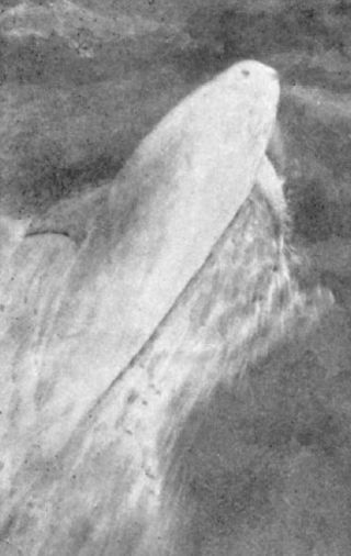
Pelorus Jack was a Risso's dolphin that was famous for meeting and escorting ships through a stretch of water in Cook Strait, New Zealand. The animal was reported over a 24 year period, from 1888 until his disappearance after 1912. Pelorus Jack was usually spotted in Admiralty Bay between Cape Francis and Collinet Point, near French Pass, a notoriously dangerous channel used by ships travelling between Wellington and Nelson.

<span class="mw-page-title-main">The Brothers (New Zealand)</span>

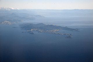
The Brothers is a group of small islands in Cook Strait, New Zealand, off the east coast of Cape Koamaru, Arapaoa Island. The islands are a restricted-access wildlife sanctuary administered by the Department of Conservation.

<span class="mw-page-title-main">Pelorus Sound</span> Largest of the Marlborough Sounds, New Zealand

Pelorus Sound is the largest of the sounds which make up the Marlborough Sounds at the north of the South Island, New Zealand.

<span class="mw-page-title-main">Pelorus River</span> River in Marlborough, New Zealand

Te Hoiere / Pelorus River is a river at the northern end of South Island of New Zealand in the region of Marlborough. It flows from the Richmond Range into Pelorus Sound / Te Hoiere. This area is fantastic for camping and is renowned for its magnificent river swimming where the Pelorus River runs through a gorge at Pelorus Bridge.

Ngāti Kuia is a Māori iwi of the Northern South Island in New Zealand. They first settled in the Pelorus Sound / Te Hoiere, and later spread to the Marlborough Sounds, Nelson and Tasman districts to Taitapu on the West Coast, and as far south as the Nelson Lakes National Park. Ngāti Kuia tradition states that their founding tupuna Matua Hautere, a descendant of Kupe, came to Te Waipounamu in his waka Te Hoiere, guided by the kaitiaki Kaikaiawaro.

<span class="mw-page-title-main">Ocean power in New Zealand</span> Renewable energy sources

New Zealand has large ocean energy resources but does not yet generate any power from them. TVNZ reported in 2007 that over 20 wave and tidal power projects are currently under development. However, not a lot of public information is available about these projects. The Aotearoa Wave and Tidal Energy Association was established in 2006 to "promote the uptake of marine energy in New Zealand". According to their 10 February 2008 newsletter, they have 59 members. However, the association doesn't list its members.

Admiralty Bay is a large indentation in the northern coast of New Zealand's South Island. It lies close to the northernmost mainland point of the Marlborough Sounds, immediately to the south of D'Urville Island.

<span class="mw-page-title-main">Golden Bay / Mohua</span> Bay in New Zealand

Golden Bay is a large shallow bay in New Zealand's Tasman District, near the northern tip of the South Island. An arm of the Tasman Sea, the bay lies northwest of Tasman Bay and Cook Strait. It is protected in the north by Farewell Spit, a 26 km long arm of fine golden sand that is the country's longest sandspit. The Aorere and Tākaka rivers are the major waterways to flow into the bay from the south and the west.

<span class="mw-page-title-main">Marlborough Sounds Important Bird Areas</span>

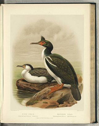
The Marlborough Sounds Important Bird Areas are four distinct sites comprising several small, rocky islets contained within an area with a maximum linear extent of 40 km, in New Zealand. They lie close to Cook Strait in the outer Marlborough Sounds at the northern end of the South Island. The sites are Duffers Reef, Sentinel Rock, White Rocks and the Trio Islands. They have been identified as Important Bird Areas (IBAs) by BirdLife International because they hold the only known colonies, and encompass the entire breeding range, of the vulnerable rough-faced shag.

The history of the Nelson Region of New Zealand dates back to settlement by the Māori people in about the 12th century. The Nelson and Marlborough Region were known to the Māori as Te Tau Ihu o Te Waka a Maui which means "The Prow of the Canoe of Maui".

<span class="mw-page-title-main">Te Matuku Marine Reserve</span>

Te Matuku Marine Reserve is a marine reserve administered by the New Zealand Department of Conservation. It includes Te Matuku Bay, one of the largest and least disturbed estuaries on Waiheke Island, as well as a surrounding area of sea. It covers an area of 690 ha and was established in 2003.

<span class="mw-page-title-main">Moana Uta (Wet Jacket Arm) Marine Reserve</span> Marine reserve in New Zealand territorial waters

Moana Uta Marine Reserve is a marine reserve covering the entire length of Wet Jacket Arm in Fiordland on New Zealand's South Island, an area of 2,007 hectares. It was established in 2005 and is administered by the Department of Conservation.

<span class="mw-page-title-main">French Pass Lighthouse</span> Lighthouse in New Zealand

The French Pass Lighthouse together with a stone beacon mark a channel through the turbulent waters between Rangitoto ki te Tonga / D’Urville Island and the South Island. The New Zealand List of Lights calls the lighthouse Channel Point.

References

40°55′19″S173°50′1″E / 40.92194°S 173.83361°E / -40.92194; 173.83361