
Valley Acres is a census-designated place (CDP) in Kern County, California, United States. Valley Acres is located 5.2 miles (8.4 km) north-northeast of Taft, at an elevation of 420 feet (128.02 m). The population was 527 at the 2010 census, up from 512 at the 2000 census.

Highland was a former unincorporated community and former census-designated place (CDP) in Benton County, Washington, United States. The population was 3,388 at the 2000 census. The area was not listed as a CDP for the 2010 census and the inhabited north end from S Olympia Street to Elliot Lake have since been added to Kennewick.

The Hoover Wilderness is a wilderness area in the Inyo and Humboldt-Toiyabe National Forests. It lies to the east of the crest of the central Sierra Nevada in California, to the north and east of Yosemite National Park - a long strip stretching nearly to Sonora Pass on the north and Tioga Pass on the south.
Eneas Lakes Provincial Park is a provincial park in British Columbia, Canada, located west of the town of Peachland, to the south of Peachland Creek. The park is approximately 1036 ha. in size and was established in 1968. The Eneas Lakes lie at the head of Finlay Creek.
Johnstone Creek Provincial Park is a provincial park in British Columbia, Canada, located west of the confluence of Rock Creek and the Kettle River and the town of Rock Creek. The park has a roughly 38 hectare area, and is near to the Crowsnest Highway.
Kickininee Provincial Park is a provincial park in British Columbia, Canada, located just south of the town of Summerland in that province's Okanagan region. Originally established in 1970 with approximately 7 acres (28,000 m2) of upland and 113.5 acres (0.459 km2) of foreshore, the park today comprises approximately 48.76 ha.
Monte Creek Provincial Park is a provincial park in British Columbia, Canada, located in the locality of Monte Creek, British Columbia. Created in 1996, it is only 3 hectares in size, and protects a treed river riparian area and also quiggly hole ("kekuli") sites of the Shuswap people, which have been formally studied as an archaeological site. The location was also part of the route of the Hudson's Bay Brigade Trail to the Cariboo via Kamloops from what is now the United States, as was also Monte Lake in the upper basin of the eponymous creek.

Niskonlith Lake Provincial Park is a provincial park in British Columbia, Canada, located southwest of the town of Chase.
Shuswap Lake Marine Provincial Park is a provincial park in British Columbia, Canada, comprising 894 ha. The Park has a variety of amenities including boat launch ramps, picnic areas, and 27 campsites around the perimeter of Shuswap Lake. The lake's name and that of the surrounding Shuswap Country is from the Shuswap people (Secwepemc), the most northern of the Salishan speaking people.
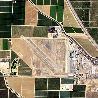
Shafter Airport, also known as Minter Field and formerly known as Air Corps Basic Flying School, is a public use airport located four nautical miles east of the central business district of Shafter and 14 miles northwest of Bakersfield, a city in Kern County, California, United States. Originally a World War II primary training facility for pilots, it is currently a public airport owned by the Minter Field Airport District. This airport is included in the National Plan of Integrated Airport Systems for 2011–2015, which categorized it as a general aviation facility.

Kimberly is an unincorporated community in Grant County, Oregon, United States. It is located at the intersection of Oregon Route 19 and Oregon Route 402 and the confluence of the John Day and the North Fork John Day rivers.

CJMG-FM is a Canadian radio station located in Penticton, British Columbia. The station, owned by Bell Media and operating at 97.1 FM with 1,800 watts of power, is branded as Move 97.1 and has an adult contemporary format.
Heppner National Forest was established as the Heppner Forest Reserve by the U.S. Forest Service in Oregon on July 18, 1906 with 292,176 acres (1,182.39 km2). It became a National Forest on March 4, 1907. On July 1, 1908 the entire forest was combined with part of Blue Mountains National Forest to establish Umatilla National Forest and the name was discontinued.
The 1877 Open Championship was the 17th Open Championship, held 6 April at Musselburgh Links, Musselburgh, East Lothian, Scotland. Jamie Anderson won the Championship, by two strokes from runner-up Bob Pringle.
Oleander is an unincorporated community in Fresno County, California. It is located 9 miles (14 km) south-southeast of downtown Fresno, at an elevation of 285 feet.

Hudson Township is one of twenty-four townships in Bates County, Missouri, and is part of the Kansas City metropolitan area within the USA. As of the 2000 census, its population was 229. As of the 2010 census, the town's population was 252. Its population was estimated to be 226 in 2018.
Sweetwater is an extinct town in Lyon County, in the U.S. state of Nevada.