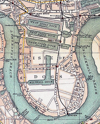
London Docklands is the riverfront and former docks in London. It is located in inner east and southeast London, in the boroughs of Southwark, Tower Hamlets, Lewisham, Newham, and Greenwich. The docks were formerly part of the Port of London, at one time the world's largest port. After the docks closed, the area had become derelict and poverty-ridden by the 1980s. The Docklands' regeneration began later that decade; it has been redeveloped principally for commercial and residential use. The name "London Docklands" was used for the first time in a government report on redevelopment plans in 1971 and has since been almost universally adopted. The redevelopment created wealth, but also led to some conflict between the new and old communities in the area.

Holt is a market town, civil parish and electoral ward in the English county of Norfolk. The town is 22.8 miles (36.7 km) north of the city of Norwich, 9.5 miles (15.3 km) west of Cromer and 35 miles (56 km) east of King's Lynn. The town has a population of 3,550, rising and including the ward to 3,810 at the 2011 census. Holt is within the area covered by North Norfolk District Council. Holt has a heritage railway station; it is the south-western terminus of the preserved North Norfolk Railway, known as the Poppy Line.
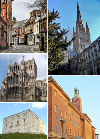
Norwich is a cathedral city and district of the county of Norfolk, England of which it is the county town. Norwich is by the River Wensum, about 100 mi (160 km) north-east of London, 40 mi (64 km) north of Ipswich and 65 mi (105 km) east of Peterborough. As the seat of the See of Norwich, with one of the country's largest medieval cathedrals, it is the largest settlement and has the largest urban area in East Anglia. The population of the Norwich City Council local authority area was estimated to be 144,000 in 2021, which was an increase from 143,135 in 2019. The wider built-up area had a population of 213,166 in 2019.

The River Wensum is a chalk river in Norfolk, England and a tributary of the River Yare, despite being the larger of the two rivers. The river is a biological Site of Special Scientific Interest and Special Area of Conservation.

Dunoon is the main town on the Cowal peninsula in the south of Argyll and Bute, Scotland. It is located on the western shore of the upper Firth of Clyde, to the south of the Holy Loch and to the north of Innellan. As well as forming part of the council area of Argyll and Bute, Dunoon also has its own community council. Dunoon was a burgh until 1976.

Docklands, also known as Melbourne Docklands, is an inner-city suburb in Melbourne, Victoria, Australia, 2 km (1.2 mi) west of Melbourne's Central Business District, located within the City of Melbourne local government area. Docklands recorded a population of 15,495 at the 2021 census.

Fakenham is a market town and civil parish in Norfolk, England. It is situated on the River Wensum, about 25 miles north-west of Norwich. The town is at the junction of several local roads, including the A148 from King's Lynn to Cromer, the A1067 to Norwich and the A1065 to Swaffham.

Swanton Morley is a village and civil parish situated in the English county of Norfolk. It is situated in the heart of Norfolk 18 miles from the centre of Norwich and three miles from Dereham, at the geographical centre of Norfolk. It covers an area of 11.14 km2 (4.30 sq mi) and had a population of 2,415 in 783 households at the 2001 census, reducing to a population of 2,100 in 723 households at the 2011 Census. For the purposes of local government it is in the Elmham and Mattishall Division of Norfolk County Council and the Lincoln Ward of Breckland District Council.
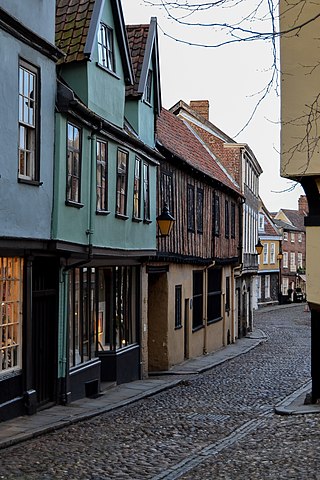
Elm Hill, Norwich is a historic cobbled lane in Norwich, Norfolk with many buildings dating back to the Tudor period. It is a famous Norwich landmark and features the Briton's Arms coffee house, The Stranger's Club, Pettus House ,The Tea House and the Dormouse Bookshop.

Dragon Hall is a Grade-1 listed medieval merchant's trading hall located in King Street, Norwich, Norfolk, close to the River Wensum, and since 2018 home to the National Centre for Writing. It is thought to be unique in being the only such trading hall in Northern Europe to be owned by one man. The building stands on what was the main road through the city in the 15th century, with river transport links via Great Yarmouth to the Low Countries. Dragon Hall is now acknowledged as one of Norwich's medieval architectural gems and an iconic building in the city.
Sir Bernard Melchior Feilden CBE FRIBA was a conservation architect whose work encompassed cathedrals, the Great Wall of China and the Taj Mahal.

Norwich Over the Water was a medieval district or court leet within the English city of Norwich, one of the four courts in the city used to deal with offences by petty criminals. The term was later used as the name for the city's northernmost electoral district, until reorganisation occurred during the 1830s.

Norwich Market is an outdoor market consisting of around 200 stalls in central Norwich, England. Founded in the latter part of the 11th century to supply Norman merchants and settlers moving to the area following the Norman conquest of England, it replaced an earlier market a short distance away. It has been in operation on the present site for over 900 years.

Feilden Clegg Bradley Studios is a British architectural design firm, established in 1978, with offices in Bath, London, Manchester and Belfast. The firm is known for its pioneering work in sustainable design and social design agenda.

The Paddington Reservoir is a heritage-listed public park located at 255a Oxford Street in the inner eastern Sydney suburb of Paddington. It was designed by Edward Bell and built from 1864 to 1866 and operated as a water reservoir which accepted water from the Botany Swamps pumping station for supply to parts of Sydney between 1866 and 1899. In the twentieth century the site variously functioned as a service station and storage and mechanical workshop site. In 2006 work commenced to convert the site into a sunken garden and park. It is also known as Walter Read Reserve; Paddington Reservoir Gardens; Reservoir Gardens. The property is owned by City of Sydney. It was added to the New South Wales State Heritage Register on 2 April 1999.

Norwich 12 was an initiative by the Norwich Heritage Economic and Regeneration Trust (HERT) to develop 12 of Norwich's most iconic buildings into an integrated family of heritage attractions to act as an international showcase of English urban and cultural development over the last 1,000 years.

Newtown Pery is an area of central Limerick, Ireland, and forms the main city centre of the city. The district is known for its Georgian architectural heritage and is the core area of Limerick's Georgian Quarter. It is one of the three towns that make up modern-day Limerick City Centre, the other two being the older Englishtown and Irishtown, which date from the medieval period. Newtown Pery houses the largest collection of Georgian townhouses in Ireland outside of Dublin. In 1837, Samuel Lewis in his Topographical Dictionary of Ireland described Newtown Pery as "one of the handsomest towns in Ireland".

The Rockhampton Customs House is a heritage-listed customs house at 208 Quay Street, Rockhampton, Rockhampton Region, Queensland, Australia. It was built from 1899 to 1900 by Caskie and Thompson. It was added to the Queensland Heritage Register on 7 February 2005.

The Old Police Station, The Rocks is a heritage-listed former police station and now home to Sergeant Lok, a Modern Asian restaurant and bar, that is located at 127–129 George Street in the inner city Sydney suburb of The Rocks in the City of Sydney local government area of New South Wales, Australia. It was designed by James Barnet and built in 1882 by W. Cains and Sons. The property is owned by Property NSW, an agency of the Government of New South Wales. It was added to the New South Wales State Heritage Register on 10 May 2002.

Waterloo Park is a Grade II* listed public park in Norwich, Norfolk. It forms one of a set of public parks established in Norwich in the 1930s by Captain Arnold Sandys-Winsch that were built by unemployed men using government funding. The original open space, then known as the Catton Recreation Ground, was opened as Waterloo Park in May 1904. When the redesigned park was opened in 1933, it was considered to be the finest in East Anglia, with a pavilion in the style of Moderne architecture, a bandstand, sports facilities, gardens and a children's playground. The herbaceous border is one of the longest in the United Kingdom located within a public space.
