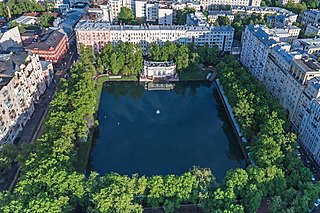
Patriarch's Ponds is park, pond and an affluent residential area in downtown Presnensky District of Moscow, Russia. For the last 200 years, there has been only one pond, although, as the name of Tryokhprudny Pereulok suggests, there used to be more. The area of the existing pond is 9,900 square metres (107,000 sq ft); the depth is about two meters.

Khamovniki District is a district of Central Administrative Okrug of the federal city of Moscow, Russia. Population: 102,730 (2010 Census); 97,110 (2002 Census).

The Garden Ring, also known as the "B" Ring, is a circular ring road avenue around central Moscow, its course corresponding to what used to be the city ramparts surrounding Zemlyanoy Gorod in the 17th century.

Zaryadye is a historical district in Moscow established in the 12th or 13th century within Kitai-gorod, between Varvarka Street and the Moskva River. The name means "the place behind the rows", i.e., behind the market rows adjacent to Red Square.

Moskvoretskaya Embankment is a major street, located in the Kitay-Gorod administrative district in central Moscow, running along the Moskva River.

Yakimanka District is a district of Central Administrative Okrug of the federal city of Moscow, Russia. Population: 26,578 (2010 Census); 22,822 (2002 Census).

Dorogomilovo District is a district of Western Administrative Okrug of the federal city of Moscow, Russia. The area of the district is 7.93 square kilometres (3.06 sq mi). Population: 67,720 (2010 Census); 59,732 (2002 Census). Postal codes: 113000 to 119000.

Alexander Alexandrovich Bashilov was a Russian general officer of Napoleonic Wars period, later engaged in urban planning of Moscow and its suburbs.

Meshchansky District is a district of Central Administrative Okrug of the federal city of Moscow, Russia. Population: 58,002 (2010 Census); 56,077 (2002 Census).

Sivtsev Vrazhek is a radial lane in the Central Administrative Okrug of Moscow; it forms the boundary between Arbat and Khamovniki municipal districts. The lane begins at a T-junction with Gogolevsky Boulevard and runs west, roughly parallel to Arbat Street (north) and Prechistenka Street (south), ending at a T-junction with Denezhny Lane, one block short of the Garden Ring. The name of the lane, literally Sivka stream gully, refers to a historical stream now locked in an underground sewer and is only one of two Vrazheks in present-day Moscow.

Beklemishevskaya Tower is a tower at the Eastern edge of Moscow Kremlin Wall. It was named after a boyar Ivan Bersen-Beklemishev, whose house had been adjacent to the tower from the Kremlin side. It was earlier known as Russian: Москворецкая tower based its position on the near Moskva River. It is similar to the other two towers standing at the other corners of the Kremlin triangle, Vodovzvodnaya and Uglovaya Arsenalnaya rowers. While these towers are cylindrical, all other towers of the Kremlin's Wall have been built on a square plan base.

Voznesensky Lane is a lane in Arbat and Prenya districts of the Central Administrative District of the Federal City of Moscow. Voznesensky Lane passes from Bolshaya Nikitskaya Street Tverskaya Street between Leontevsky Lane and Bryusov Lane. Numbering of houses begins from Bolshaya Nikitskaya Street.

Zaryadye Park is a landscape urban park located adjacent to Red Square in Moscow, Russia, on the site of the former Zaryadye district. The park was inaugurated on 9 September 2017 by Russian President Vladimir Putin and Moscow Mayor Sergey Sobyanin.
The House of Lopukhin was an old Russian noble family, most influential during the Russian Empire, forming one of the branches of the Sorokoumov-Glebov family.
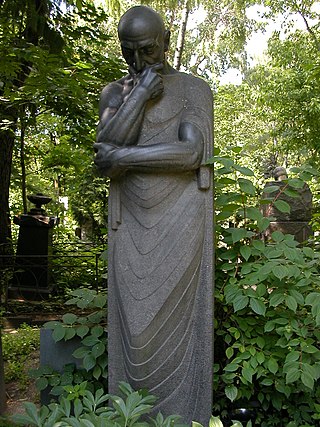
Thought is a sculpture made by S. D. Merkurov in 1911–1913. In 1955 it was installed on Merkurov's grave at the Novodevichy Cemetery.
Kamergerskiy Pereulok or Chamberlain Lane is a short street with many historical buildings located within the Boulevard Ring in central Moscow. Almost all of the buildings on Chamberlain Lane are classified as architectural monuments.
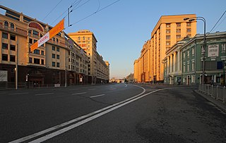
Okhotny Ryad is a street located in Tverskoy District of Moscow. It runs from Manezhnaya Square to Theatre Square and it also lies between Georgievsky Lane and Nikolskaya Street. The numbering of houses is carried out from Manezhnaya Square.

Bolshaya Dmitrovka Street is a street located in Tverskoy District of Moscow. It runs from Okhotny Ryad to Strastnoy Boulevard. The numbering of houses is carried out from Okhotny Ryad.
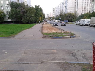
Korneychuka Street is a street in the Bibirevo District, North-Eastern Administrative Okrug, Moscow.
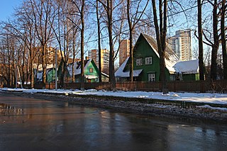
Sokol also known as "artists' settlement" ) is the first cooperative residential settlement in Moscow, founded in 1923. It is located in the Northern Administrative Okrug, not far from the later built Sokol metro station. The settlement "Sokol" became one of the embodiments of the garden city concept. Since 1979, the settlement has been under state protection as a monument to urban development of the first years of Soviet power. Since 1989, the settlement "Sokol" has been self-governing. The architects of the settlement "Sokol" implemented the concept of the "garden city", which was popular in the early 20th century. The idea of a settlement that would combine the best features of the city and the village was put forward by the British Ebenezer Howard in 1898. As early as 1903, a project appeared to build a similar garden city on Khodynka Field in Moscow. This project was being developed for some time, but the events of 1914-1917 prevented its implementation. The urban development plans of the 1920s - "New Moscow" by Alexey Shchusev and "Greater Moscow" by Sergei Shestako - also widely used the idea of a "garden city". The outskirts and suburbs of Moscow were supposed to be built up with settlements consisting of low-rise buildings, which were to have their own libraries, clubs, sports and children's playgrounds and kindergartens.
