
Sierra Vista is a city in Cochise County, Arizona, United States. According to the 2020 Census, the population of the city is 45,308, and is the 27th most populous city in Arizona. The city is part of the Sierra Vista-Douglas Metropolitan Area, with a 2010 population of 131,346. Fort Huachuca, a U.S. Army post, has been incorporated and is located in the northwest part of the city. Sierra Vista is bordered by the cities of Huachuca City and Whetstone to the north and Sierra Vista Southeast to the South.

Tower Hamlets Cemetery Park is a local nature reserve and historic cemetery in the London Borough of Tower Hamlets within the East End of London. It is regarded as one of the seven great cemeteries of the Victorian era, the "Magnificent Seven", instigated because the normal church burial plots had become overcrowded. Since the 1990s it has been managed by the Friends of Tower Hamlets Cemetery Park, a registered charity, with the purpose of protecting, preserving and promoting this important space for conservation, heritage and community.

El Campo Santo is a cemetery located at the Workman and Temple Family Homestead Museum, 15415 East Don Julian Road, in City of Industry, California.

Crown Hill Cemetery is a historic rural cemetery located at 700 West 38th Street in Indianapolis, Marion County, Indiana. The privately owned cemetery was established in 1863 at Strawberry Hill, whose summit was renamed "The Crown", a high point overlooking Indianapolis. It is approximately 2.8 miles (4.5 km) northwest of the city's center. Crown Hill was dedicated on June 1, 1864, and encompasses 555 acres (225 ha), making it the third largest non-governmental cemetery in the United States. Its grounds are based on the landscape designs of Pittsburgh landscape architect and cemetery superintendent John Chislett Sr and Prussian horticulturalist Adolph Strauch. In 1866, the U.S. government authorized a U.S. National Cemetery for Indianapolis. The 1.4-acre (0.57 ha) Crown Hill National Cemetery is located in Sections 9 and 10.

Magnolia Cemetery is a historic city cemetery located in Mobile, Alabama. Filled with many elaborate Victorian-era monuments, it spans more than 100 acres (40 ha). It served as Mobile's primary, and almost exclusive, burial place during the 19th century. It is the final resting place for many of Mobile's 19th- and early 20th-century citizens. The cemetery is roughly bounded by Frye Street to the north, Gayle Street to the east, and Ann Street to the west. Virginia Street originally formed the southern border before the cemetery was expanded and now cuts east–west through the center of the cemetery. Magnolia contains more than 80,000 burials and remains an active, though very limited, burial site today.

High Street Cemetery is a historic cemetery at 45 High Street in Danvers, Massachusetts. The 0.6-acre (0.24 ha) cemetery is one of the older cemeteries in town, and occupies a prominent location in the town center.

Bailly Cemetery is a cemetery located at Indiana Dunes National Park in Porter, Indiana, US. The cemetery is three-quarters of a mile (1.2 km) north of the Joseph Bailly Homestead on the edge of a sand ridge. The first recorded burial was Robert, the son of Joseph Bailly, in about 1827. Subsequently, the site has been considered a family graveyard. Burials of those outside the Bailly family are numerous. Today, they are all unmarked, including Swedish residents of the area. Outside the cemetery platform to the north there are eight recorded tombstones, four of which are older than 1827: Isaac Schellinger, 1811; Peter Carlbon, 1814; Rhoda Schellinger, 1816; and Thomas B. Speer, 1817.

The Gideon Putnam Burying Ground is located on South Franklin Street in Saratoga Springs, New York, United States. It contains over 150 graves of early and mid-19th century residents of the city, all from the period between 1812 and 1871. It was restored in the 1980s after suffering from almost a century of neglect.

The Revolutionary War Cemetery, also called the Old Salem Burying Ground, is located on Archibald Street, just off state highway NY 22 in the village of Salem, New York, United States. It is a 2.6-acre (1.1 ha) area with over a thousand graves, at least 100 of which are those of Revolutionary War dead or veterans.
In the United States, Canada, Australia, and elsewhere, a pioneer cemetery is a cemetery that is the burial place for pioneers. American pioneers founded such cemeteries during territorial expansion of the United States, with founding dates spanning, at least, from the late 18th to early 20th centuries.
Home of Peace is a Jewish cemetery in Helena, Montana, founded in 1867 by the local Hebrew Benevolent Society, which formed on December 9, 1866. The Society formally purchased the land in 1875. The Home of Peace Cemetery Association now maintains the grounds. It is the oldest active cemetery in Helena and the oldest active European ethno-religious cemetery in Montana. There are three major sections of land owned by the Association: the cemetery, undeveloped adjacent land, and land leased to the Helena School District since 1975. The portion leased by the school district is a practice football field for Capital High School and contains unmarked graves from the earliest days of the cemetery. The original wrought iron fence erected in 1867 still stands except on the north side and is in disrepair in places. A granite gateway erected in 1910 is at the main entrance. The east gate also has granite markers. There is a water tower, pump house, and landscaping shed. Twelve broken tombstones lie at the base of the water tower. The northwest corner has remained undeveloped and in its natural wild state. In 1910 cottonwood trees were planted along the driveway.

The Old North Cemetery is the oldest cemetery in Truro, Massachusetts. The cemetery, formerly the Old North Graveyard, was established in 1713 on the Hill of Storms where the first church in Truro was built in 1709. It remained the town's only cemetery until 1799 when the Pine Grove Cemetery was established. Old North is on US Route 6 between Aldrich Road and South Highland Road. Many individuals associated with Truro's early development are buried here, as are ship's captains. When originally laid out, the cemetery was about 3 acres (1.2 ha) in size; it was expanded in 1926 and again in 1974 and is now 5.8 acres. The oldest part of the cemetery is its northernmost section, abutting Aldrich Road. As of 2022 there are approximately 1,670 burials in the cemetery. Over half of those buried in the original "Old Stone" (north) section were less than 50 years old when they died.

The Putnam Cemetery is a historic cemetery on SE Metro Parkway, just south of Walton Boulevard, in Bentonville, Arkansas. Now completely surrounded by commercial development, this small cemetery is ringed by an iron fence with an arch identifying it, and is located just behind hotels that front on Walton Boulevard. The cemetery was established in 1860, and was the family burial ground of the Putnam family, who were some of Benton County's earliest settlers. It has fourteen marked graves, and an unknown number of unmarked ones.
The Spring Creek Friends Cemetery is a historic site located northeast of Oskaloosa, Iowa, United States. The approximately one-half acre plot of land contains an unknown number of burials with about 123 having plain markers that date from the 1860s through the 1890s. There is a network of pedestrian paths in the cemetery, and it is surrounded by a fence with concrete posts on the south, west, and north sides. The cemetery was founded about 1848 and continued to accept burials until about 1892. It calls attention to the earliest period of Quaker settlement in Iowa, which at that time was primarily a rural phenomenon. The Spring Creek Meeting was established here in the 1840s or the 1850s, and was the site of the first Iowa Yearly Meeting in 1863. The Spring Creek Meeting merged with the Center Grove Meeting in 1894 and formed the Oskaloosa Monthly Meeting. The meetinghouse subsequently moved into Oskaloosa, and burials here dropped off. The cemetery was listed on the National Register of Historic Places in 1996.
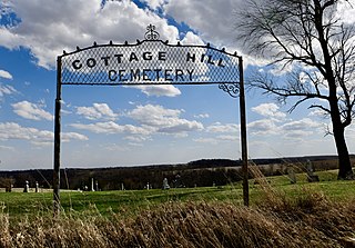
The Cottage Hill Methodist–Episcopal Cemetery is a historic site located in Concord Township, Dubuque County, Iowa, United States. The cemetery was established in 1843 when the first burial took place. It is significant as a representation of the pioneer settlement era and the development of the village of Cottage Hill, no longer extant, and the surrounding area. Its period of significance continues until 1909 when the last settler was buried here. The last burial here was in 1991.

The Concord Congregational Cemetery is a historic site located in Concord Township, Dubuque County, Iowa, United States. The cemetery was established in 1856 when the first burial took place. It is significant as a representation of the pioneer settlement era and the development of the village of Cottage Hill, no longer extant, and the surrounding area. Its period of significance continues until 1906 when the last burial took place.
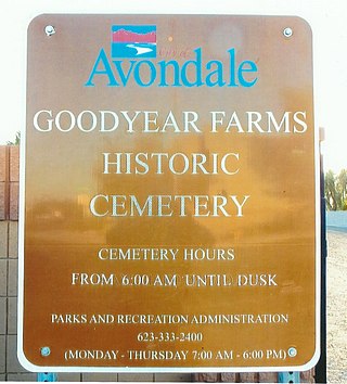
The Goodyear Farms Historic Cemetery is the official name given to a historic cemetery located at 3900 N Santa Fe Trail in the city of Avondale, Arizona. In the past the cemetery was known as the "Pioneer Cemetery" and also as the "Litchfield Cemetery". It is the final resting place of many Mexican migrants and Native-Americans who worked in the Goodyear Farms and the Wigwam Resort in Litchfield Park. The majority of the unmarked graves are of those who perished in the 1918 Spanish Influenza pandemic which spread throughout the entire globe. The Pioneers' Cemetery Association (PCA) defines an "historic cemetery" as one which has been in existence for more than fifty years.
Long Plain Cemetery is a historic cemetery at 19 Depot Road in Leverett, Massachusetts. The 1-acre (0.40 ha) cemetery is located on the south side of the street about 1.5 miles (2.4 km) west of Leverett center. The cemetery, whose oldest documented burials date to 1781, was listed on the National Register of Historic Places in 2020. Its burials include some of the town's early residents, and it remains in active use.
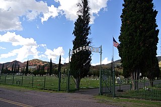
Evergreen Cemetery is a cemetery in Bisbee, Arizona, located in the Lowell area of the city, along old U.S. Highway 80. It is also known as the Lowell Cemetery. It was officially established in May 1912, and contains over 10,000 graves, being the main cemetery for the city. It was added to the National Register of Historic Places on October 7, 2005.


