Related Research Articles

Gippsland is a rural region that makes up the southeastern part of Victoria, Australia, mostly comprising the coastal plains to the rainward (southern) side of the Victorian Alps. It covers an elongated area of 41,556 km2 (16,045 sq mi) located further east of the Shire of Cardinia between Dandenong Ranges and Mornington Peninsula, and is bounded to the north by the mountain ranges and plateaus/highlands of the High Country, to the southwest by the Western Port Bay, to the south and east by the Bass Strait and the Tasman Sea, and to the east and northeast by the Black–Allan Line.

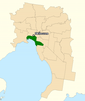
The City of Melton is a local government area in Victoria, Australia, on Melbourne's western rural–urban fringe.

The Shire of Macedon Ranges is a region in Central Victoria, Australia, best known for its native forests, geographical attraction Hanging Rock, and artisan food and wine industries. The region covers an area of 1,748 square kilometres (675 sq mi). It is located in between the cities of Bendigo and Melbourne. In August 2021 the shire had a population of 51,458. It includes the towns of Gisborne, Gisborne South, Kyneton, Lancefield, Macedon, Malmsbury, Mount Macedon, New Gisborne, Riddells Creek, Romsey and Woodend.

The Mount Alexander Shire is a local government area in Victoria, Australia, located in the central part of the state. It covers an area of 1,530 square kilometres (590 sq mi) and, in August 2021, had a population of 20,253. It includes the towns of Castlemaine, Chewton, Elphinstone, Maldon, Newstead, Harcourt, Taradale, Vaughan, Fryerstown and Campbells Creek. It was formed in 1995 from the amalgamation of the City of Castlemaine, Shire of Newstead, and most of the Shire of Maldon and Shire of Metcalfe. The traditional owners of the land are Dja Dja Wurrung.

Eltham is a suburb of Melbourne, Victoria, Australia, 20 km north-east of the Central Business District, located within the Shire of Nillumbik local government area. Eltham recorded a population of 18,847 at the 2021 census.
Deakin University is a public university in Victoria, Australia. Founded in 1974, the university was named after Alfred Deakin, the second Prime Minister of Australia.
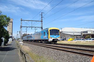
The Upfield Shared Path is a shared use path for cyclists and pedestrians, which follows Upfield railway line through the inner northern suburbs of Melbourne, Victoria, Australia.
This is a timeline of Australian history, comprising important legal and territorial changes and political events in Australia and its predecessor states. To read about the background to these events, see history of Australia. See also the list of prime ministers of Australia.
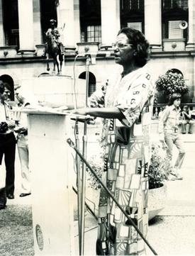
Oodgeroo Noonuccal ( UUD-gə-roo NOO-nə-kəl; born Kathleen Jean Mary Ruska, later Kath Walker was an Aboriginal Australian political activist, artist and educator, who campaigned for Aboriginal rights. Noonuccal was best known for her poetry, and was the first Aboriginal Australian to publish a book of verse.

The Division of Melbourne is an Australian electoral division in the State of Victoria, represented since the 2010 election by Adam Bandt, leader of the Australian Greens.

The Division of Wills is an Australian electoral division of Victoria. It is currently represented by Peter Khalil of the Australian Labor Party.
Keyline design is a landscaping technique of maximizing the beneficial use of the water resources of a tract of land. The "keyline" is a specific topographic feature related to the natural flow of water on the tract. Keyline design is a system of principles and techniques of developing rural and urban landscapes to optimize use of their water resources.

Bundall is a suburb in the City of Gold Coast, Queensland, Australia. In the 2016 census, Bundall had a population of 4,523 people.
Ultra Records is an American record label owned by Sony Music Entertainment, which is a subsidiary of Sony Corporation of America.
The Division of Melbourne Ports was an Australian federal electoral division in the inner south-eastern suburbs of Melbourne, Victoria, Australia. It was located to the south of Melbourne's central business district and covered an area of approximately 40 km2 around the north and north-eastern shores of Port Phillip Bay.

The Shire of Newstead was a local government area about 120 kilometres (75 mi) northwest of Melbourne, the state capital of Victoria, Australia. The shire covered an area of 409.22 square kilometres (158.0 sq mi), and existed from 1860 until 1995.
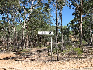
Irishtown is a locality near Castlemaine, Victoria, Australia. It is noted for heritage sites associated with the Victorian Gold Rush, near or within the Castlemaine Diggings National Heritage Park. These include the Red Hill hydraulic gold sluicing site and the Burying Flat Cemetery, also known as Deadmans Gully Burial Ground.

The Church Street Bridge is an historic road arch bridge over the Yarra River and the Monash Freeway in Melbourne, Victoria, Australia. It links Church Street in Richmond on the north bank with Chapel Street in South Yarra on the south.

Haymarket roundabout is a roundabout located at the intersection of Elizabeth Street, Flemington Road and Peel Street near the northwest border of the Melbourne central business district in Australia. It is also the location of two tram stops. Royal Parade appears to begin at the roundabout. However, the block north of the roundabout, as far as Grattan Street, is formally still Elizabeth Street.

The Grampians is an economic rural region located in the western part of Victoria, Australia. The 48,646-square-kilometre (18,782 sq
References
- ↑ Davine, Anna (27 May 2015). "Fryerstown, VIC". Electronic Encyclopedia of Gold in Australia. Archived from the original on 8 August 2015. Retrieved 4 April 2016.
- ↑ Davine, Anna (27 May 2015). "Fryers Forest, VIC". Electronic Encyclopedia of Gold in Australia. Archived from the original on 8 August 2015. Retrieved 4 April 2016.