Related Research Articles

The Canary Islands, also known informally as the Canaries, are a Spanish autonomous community and archipelago in the Atlantic Ocean, in Macaronesia. At their closest point to the African mainland, they are 100 kilometres west of Morocco. They are the southernmost of the autonomous communities of Spain. The islands have a population of 2.2 million people and they are the most populous special territory of the European Union.
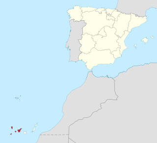
Province of Santa Cruz de Tenerife, also Province of Santa Cruz, is a province of Spain, consisting of the western part of the autonomous community of the Canary Islands. It consists of about half of the Atlantic archipelago: the islands of Tenerife, La Gomera, El Hierro, and La Palma. It occupies an area of 3,381 km2 (1,305 sq mi). It also includes a series of adjacent roques.

Tourism in Spain is a major contributor to national economic life, contributing to about 11.8% of Spain's GDP. Ever since the 1960s and 1970s, the country has been a popular destination for summer holidays, especially with large numbers of tourists from the United Kingdom, Ireland, Turkey, France, Germany, Italy, the Benelux, and the United States, among others. Accordingly, Spain's foreign tourist industry has grown into the second-biggest in the world.

Las Palmas, officially Las Palmas de Gran Canaria, is a Spanish city and capital of Gran Canaria, in the Canary Islands, on the Atlantic Ocean.

Tenerife is the largest and most populous island of the Canary Islands. It is home to 43% of the total population of the archipelago. With a land area of 2,034 square kilometres (785 sq mi) and a population of 978,100 inhabitants as of January 2022, it is also the most populous island of Spain and of Macaronesia.

Teide, or Mount Teide, is a volcano on Tenerife in the Canary Islands, Spain. Its summit is the highest point in Spain and the highest point above sea level in the islands of the Atlantic.

Tereré is an infusion of yerba mate prepared with cold water, a lot of ice and pohá ñaná, and in a slightly larger vessel. This infusion has its roots in Pre-Columbian America, which established itself as traditional during the time of Governorate of Paraguay. The Guaraní people call this infusion ka'ay, where ka'a means herb and y means water. There's also a variant made with juice, called "Juice tereré" or "Russian tereré", depending on the region. On December 17 2020, Unesco declared the tereré of Paraguay as an intangible cultural heritage, which includes the drink (tereré) and its preparation methods with medicinal herbs.
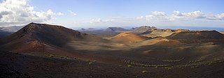
Timanfaya National Park is a Spanish national park in the southwestern part of the island of Lanzarote, in the Canary Islands. It covers parts of the municipalities Tinajo and Yaiza. The area is 51.07 square kilometres (19.72 sq mi), and the parkland is entirely made up of volcanic soil. The statue El Diablo by César Manrique is its symbol. It is the only Natural Park in Spain which is entirely geological. Timanfaya National Park represents a sign of recent and historical volcanism in the Macaronesian Region. The last volcanic eruptions occurred during the 18th century as well as on the 19th century.

Vilaflor is a municipality and village in the south-central part of the island of Tenerife, one of the Canary Islands, and part of Santa Cruz de Tenerife (province), Spain. Vilaflor, with an altitude of 1,400 m, is the highest village on Tenerife, situated south of the Teide volcano. It is located 7 km north of San Miguel de Abona and 51 km southwest of the island's capital Santa Cruz de Tenerife. The population is 1,645 (2018) and the area is 56.26 km².

Garajonay National Park is located in the center and north of the island of La Gomera, one of the Canary Islands (Spain). It was declared a national park in 1981 and a World Heritage Site by UNESCO in 1986. It occupies 40 km2 and it extends into each of the six municipalities on the island.

The Rías Baixas are a series of four estuarine inlets located on the southwestern coast of Galicia, Spain. They are the Ría de Muros e Noia, the Ría de Arousa, the Ría de Pontevedra, and the Ría de Vigo. The northernmost Rías Baixas begin below Cape Finisterre while the southernmost rias border the Portuguese coast, taking up the southern part of the Province of Coruña and the entire Province of Pontevedra. Its capital is the city of Pontevedra. Due to unique conditions, the Rías Baixas are rich in marine life which helps the fishing and aquaculture industry of the area. Beaches, marinas, distinctive towns, and plenty of water activities also attract tourists, providing another source of income.
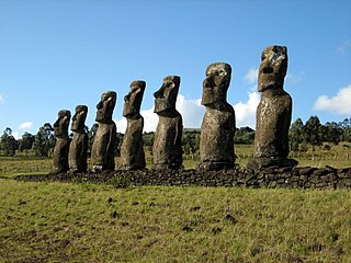
Rapa Nui National Park is a national park and UNESCO World Heritage Site located on Easter Island, Chile. Rapa Nui is the Polynesian name of Easter Island; its Spanish name is Isla de Pascua. The island is located in the southeastern Pacific Ocean, at the southeastern extremity of the Polynesian Triangle. The island was taken over by Chile in 1888. Its fame and World Heritage status arise from the 887 extant stone statues known by the name "moai", whose creation is attributed to the early Rapa Nui people who inhabited the island starting between 300 and 1200 AD. Much of the island has been declared as Rapa Nui National Park which, on 22 March 1996, UNESCO designated a World Heritage Site under cultural criteria (i), (iii), & (v). Rapa Nui National Park is now under the administrative control of the Ma´u Henua Polynesian Indigenous Community, which is the first autonomous institute on the island. The indigenous Rapa Nui people have regained authority over their ancestral lands and are in charge of the management, preservation and protection of their patrimony. On the first of December 2017, the ex-President Michelle Bachelet returned ancestral lands in the form of the Rapa Nui National Park to the indigenous people. For the first time in history, the revenue generated by the National Park is invested in the island and used to conserve the natural heritage.
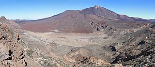
Teide National Park is a national park located in Tenerife, Canary Islands, Spain.
Tourism is an essential part of the economy of the Canary Islands, a Spanish archipelago located in the Atlantic Ocean, 100 kilometres west of Morocco. Seven main islands and six islets make up the Canary Islands. They had more than 9 million foreign incoming tourists in 2007. Tourists seeking sunshine and beaches first began to visit the Canaries in large numbers in the 1960s. The Canary Islands are a leading European tourist destination with very attractive natural and cultural resources.

The Roque Cinchado is a rock formation, regarded as emblematic of the island of Tenerife. It lies within the Teide National Park in the municipality of La Orotava, near the volcano of the same name, in the heart of the island.

Puerto de la Cruz is a city and municipality in the northern part of the island of Tenerife, Canary Islands, Spain. It was formerly known by its English translation, "Port of the Cross", although now it is known by its Spanish name in all languages. Puerto de la Cruz is located on the northern coast, 4 km (2 mi) northwest of La Orotava and 30 km (19 mi) west of Santa Cruz de Tenerife. The TF-5 motorway passes through the municipality. The population is 30,483 (2018). In Spanish, the local inhabitants are known as Portuenses. With an area of 8.73 km2 (3 sq mi), the municipality is the smallest in Tenerife. The elevation of the town's centre is 9 m (30 ft) above sea level and the highest point being Las Arenas, a volcanic cone with an elevation of 249 m (817 ft).

The National Parks Autonomous Agency (OAPN) is an autonomous agency of the Spanish central government that manages the National Parks Network and the Spanish Biosphere Reserves Network, as well as mountains, farms and other patrimonial assets of its property. The agency was created on June 23, 1995 by the Agriculture Minister Luis María Atienza by merging two other agencies, the Institute for the Conservation of Nature (ICONA) and the National Institute for Agrarian Reform and Development (IRYDA).