Fıraktın relief

Last updated

Coordinates: 38°16′18″N35°37′54″E / 38.27167°N 35.63167°E / 38.27167; 35.63167 (Fıraktın)

Geographic coordinate system Coordinate system

A geographic coordinate system is a coordinate system that enables every location on Earth to be specified by a set of numbers, letters or symbols. The coordinates are often chosen such that one of the numbers represents a vertical position and two or three of the numbers represent a horizontal position; alternatively, a geographic position may be expressed in a combined three-dimensional Cartesian vector. A common choice of coordinates is latitude, longitude and elevation. To specify a location on a plane requires a map projection.

Contents

Weather god, Hattusili III, Sun goddess Hebat, Puduhepa Felsrelief von Firaktin.jpg
Weather god, Hattušili III, Sun goddess Hebat, Puduhepa

The Hittite rock relief Fıraktın relief (or Fraktın) is located roughly 50 km south of Kayseri in the province of the same name in southern Turkey, at Fıraktın on the bank of the Enzel Dere, a tributary of the Zamantı Irmağı. Strabo called the place Dastarkon. Rock reliefs are a prominent aspect of Hittite art.

Rock relief relief sculpture carved into solid rock

A rock relief or rock-cut relief is a relief sculpture carved on solid or "living rock" such as a cliff, rather than a detached piece of stone. They are a category of rock art, and sometimes found as part of, or in conjunction with, rock-cut architecture. However, they tend to be omitted in most works on rock art, which concentrate on engravings and paintings by prehistoric peoples. A few such works exploit the natural contours of the rock and use them to define an image, but they do not amount to man-made reliefs. Rock reliefs have been made in many cultures throughout human history, and were especially important in the art of the ancient Near East. Rock reliefs are generally fairly large, as they need to be in order to have an impact in the open air. Most of those discussed here have figures that are over life-size, and in many the figures are multiples of life-size.

Kayseri Metropolitan municipality in Central Anatolia, Turkey

Kayseri is a large industrialised city in Central Anatolia, Turkey. It is the seat of Kayseri Province. The city of Kayseri, as defined by the boundaries of Kayseri Metropolitan Municipality, is structurally composed of five metropolitan districts, the two core districts of Kocasinan and Melikgazi, and since 2004, also Hacılar, İncesu and Talas.

Kayseri Province Province of Turkey in Central Anatolia

The Kayseri Province is situated in central Turkey. The population is 1,255,349 of which around 1,000,000 live in the city of Kayseri. It covers an area of 16,917 km2 and it borders with Sivas, Adana, Niğde, Kahramanmaraş, Yozgat and Nevşehir provinces.

Location

The relief is in a steep valley, between Mount Erciyes and the Anti-Taurus Mountains east of Develi. The valley was historically an important route into Cilicia (and from there into Syria via the Gezbeli and Küçük Gezbeli passes). A Mycenaean vase was found nearby, which probably came via Cilicia. [1] Between 1880 and 1939, five reliefs from Hittite times were discovered in this location, more than in any other spot in Anatolia. The other four reliefs are Hanyeri, İmamkullu and Taşçı A and B. [2]

Mount Erciyes volcano in Turkey

Mount Erciyes, also known as Argaeus, is a volcano in Turkey. It is a large stratovolcano that is surrounded by many monogenetic vents and lava domes, and one maar. The bulk of the volcano is formed by lava flows of andesitic and dacitic composition. At some time in the past, part of the summit collapsed towards the east.

The Anti-Taurus Mountains are a mountain range in southern and eastern Turkey, curving northeast from the Taurus Mountains. The tallest mountain in the range is Mount Erciyes, 12,851 feet (3,917 m) high. The ancient Greek geographer Strabo wrote that in his time the summit was never free from snow, and that those few who ascended it could see both the Black Sea and the Mediterranean.

Develi Place in Kayseri, Turkey

Develi is a town and district in Kayseri Province in Central Anatolia Region, Turkey.

Description

The relief is about 1.3 m x 3.2 m and was made in the 13th century BC, in the time of the Hittite empire. It faces northwest, towards Mount Erciyes, which like all mountains was worshiped in Hittite times. The relief is in three parts.

The left section shows the Hittite king Hattusili III (right) making an offering to the weather god, pouring water from a kind of beaked flagon into a vessel on the ground. Between them there is an altar like structure, with a grooved, conical item on top, probably offering-bread. Both the god and the king wear pointed hats, which symbolised divinity. From this, it can be concluded that the image was probably made after Hattusili's death in the reign of his son and successor Tudhaliya IV, since the Hittite kings were considered divine after their deaths. The weather god holds a crook in his hands. In front of each of their heads are hieroglyphic symbols, naming the depicted individuals.

Weather god deity in mythology associated with weather phenomena such as thunder, lightning, rain and wind

A weather god, also frequently known as a storm god, is a deity in mythology associated with weather phenomena such as thunder, lightning, rain, wind, storms and hurricanes. Should they only be in charge of one feature of a storm, they will be called a god/goddess, such as a rain god or a lightning/thunder god. This singular attribute might then be emphasized more than the generic, all-encompassing term "storm god", though with thunder/lightning gods, the two terms seem interchangeable. They feature commonly in polytheistic religions.

The Sun goddess & Puduhepa Puduhepa.jpg
The Sun goddess & Puduhepa

In the middle scene is his wife, Tawannanna Puduhepa (right), making a libation to the Sun goddess Hebat. There is an altar between these two figures as well, with a bird or a bird-shaped vessel on top of it. The depiction gets rougher on the right end; probably the work was not finished.

Libation Cultual offering of beverage to a god

A libation is a ritual pouring of a liquid, or grains such as rice, as an offering to a god or spirit, or in memory of the dead. It was common in many religions of antiquity and continues to be offered in cultures today.

The third part of the relief consists of massive Luwian hieroglyphs. The continue the description of the queen which begins beside her head, "Daughter of the land of Kizzuwatna, beloved by the divine." [2]

Kizzuwatna, is the name of an ancient Anatolian kingdom in the 2nd millennium BC. It was situated in the highlands of southeastern Anatolia, near the Gulf of İskenderun in modern-day Turkey. It encircled the Taurus Mountains and the Ceyhan river. The center of the kingdom was the city of Kummanni, situated in the highlands. In a later era, the same region was known as Cilicia.

Copy at the Kayseri Museum Firaktin2Kayseri.jpg
Copy at the Kayseri Museum

A concrete copy of the relief can be viewed at the Kayseri Museum, as well as a plaster cast in the Pergamonmuseum in Berlin.

Related Research Articles

Cappadocia Place in Katpatuka

Cappadocia is a historical region in Central Anatolia, largely in the Nevşehir, Kayseri, Kırşehir, Aksaray, and Niğde Provinces in Turkey.

Suppiluliuma II Hittite king

Suppiluliuma II, the son of Tudhaliya IV, was the last known king of the New Kingdom of the Hittite Empire, ruling c. 1207–1178 BC, contemporary with Tukulti-Ninurta I of the Middle Assyrian Empire.

Šarruma Hittite and Hurrian deity

Šarruma or Sharruma was a Hurrian mountain god, who was also worshipped by the Hittites and Luwians.

Syro-Hittite states Wikimedia list article

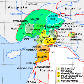
The states that are called Neo-Hittite or, more recently, Syro-Hittite were Luwian-, Aramaic- and Phoenician-speaking political entities of the Iron Age in northern Syria and southern Anatolia that arose following the collapse of the Hittite Empire in around 1180 BC and lasted until roughly 700 BC. The term "Neo-Hittite" is sometimes reserved specifically for the Luwian-speaking principalities, like Milid and Carchemish. However, in a wider sense the broader cultural term "Syro-Hittite" is now applied to all the entities that arose in south-central Anatolia following the Hittite collapse, such as Tabal and Quwê, as well as those of northern and coastal Syria.

İvriz relief

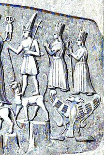
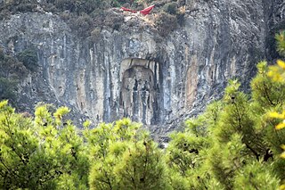
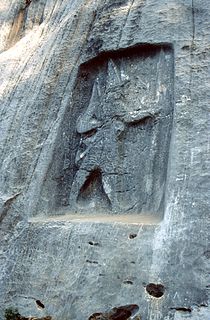
The İvriz relief is a Hittite rock relief in south-central Anatolia, located in the town of Aydınkent, formerly called İvriz. The rock relief is on a rock face near the source of the İvriz Suyu, whose water has damaged the relief in modern times. It depicts the late 8th-century BC king Warpalawas and the storm-god Tarhunzas and is accompanied by a hieroglyphic Luwian inscription. Rock reliefs are a prominent aspect of Hittite art.

Šauška Hurrian/Hittite feminine deity

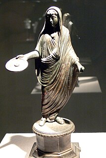
Šauška or Shaushka was a Hurrian goddess who was also adopted into the Hittite pantheon. She is known in detail because she became the patron goddess of the Hittite king Hattusili III following his marriage to Puduhepa, the daughter of the goddess' high priest. Her cultic center was Lawazantiya in Kizzuwatna.

Karatepe

Not to be confused with Karatepe, Termez, Uzbekistan, where a Buddhist mural from 3rd century was found, nor Kara Tepe Refugee Camp in Greece.

Stela of Akhenaten and his family

The Stela of Akhenaten and his family is the name for an altar image in the Egyptian Museum in Cairo which depicts the Pharaoh Akhenaten, his queen Nefertiti, and their three children. The limestone stela with the inventory number JE 44865 is 43.5 × 39 cm in size and was discovered by Ludwig Borchardt in Haoue Q 47 at Tell-el Amarna in 1912. When the archaeological finds from Tell-el Amarna were divided on 20 January 1913, Gustave Lefebvre chose this object on behalf of the Egyptian Superintendency for Antiquities instead of the Bust of Nefertiti.

Hanyeri relief

The Hanyeri relief is a Hittite rock relief near Hanyeri on the road from Tufanbeyli to Develi in Tufanbeyli district in Adana Province, about 80 km southeast of Kayseri, in Turkey. In Hittite times, the route over the 1960 m high Gezbeli Pass through the Taurus Mountains, which connected the Hittite heartland on the Kızılırmak River with Cilicia, passed by here. At the other end of the pass, to the northwest, is the İmamkullu relief. Rock reliefs are a prominent aspect of Hittite art.

İmamkullu relief

The Hittite İmamkullu relief is a rock relief near the town of İmamkullu in Tomarza district in Kayseri Province, Turkey. In Turkish it is known as Yazılı Kaya and Şimşekkaya. Rock reliefs are a prominent aspect of Hittite art.

Taşçı reliefs

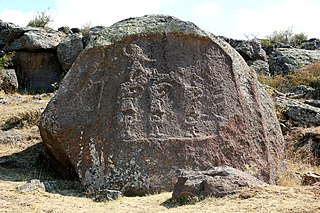
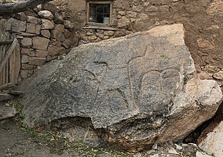
The two Taşçı reliefs are rock reliefs from the time of the Hittite empire. They are two kilometres south of Taşçı in Develi district, Kayseri Province, Turkey. They are known in Turkish as Yazılı Kaya. Rock reliefs are a prominent aspect of Hittite art.

Manisa relief

The Manisa relief, also known as the Akpınar relief and the Cybele relief, is a Hittite rock relief at Akpınar, about 5 km east of the Turkish provincial capital of Manisa above an amusement park on the road to Salihli. It depicts a Hittite divinity. Rock reliefs are a prominent aspect of Hittite art.

Hemite relief

The Hemite relief is a Hittite rock relief at Gökçedam in the central district of Osmaniye Province in Turkey, about 20 km northwest of the provincial capital of Osmaniye. Rock reliefs are a prominent aspect of Hittite art.

Karabel relief

The Hittite / Luwian Karabel relief is a rock relief in the pass of the same name, between Torbalı und Kemalpaşa, about 20 km from Izmir in Turkey. Rock reliefs are a prominent aspect of Hittite art.

Karasu relief

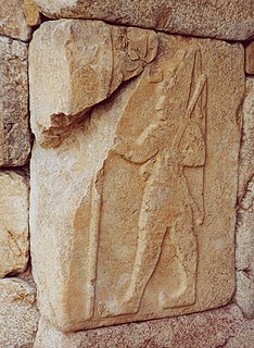
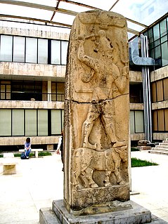
The Karasu relief, also known as the Süpürgüç relief after the earlier name of the nearby town of Akbudak, is a rock relief located on a tributary of the Euphrates and derives from the Neo-Hittite period. It depicts a protective god standing on a deer. Rock reliefs are a prominent aspect of Hittite art.

Gökbez relief

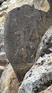
The Hittite Gökbez relief is a rock relief at Gökbez and dates from the time of the Neo-Hittite states. Rock reliefs are a prominent aspect of Hittite art.

Karatepe-Aslantaş Open-Air Museum

Karatepe-Aslantaş Open-Air Museum is an open-air museum in Osmaniye Province, Turkey. Karatepe is the location while Aslantaş refers to the lion figure on stone sculptures. The site is situated inside a nationalpark with the same name.

Tarḫunz

Tarḫunz was the weather god and chief god of the Luwians, a people of Bronze Age and early Iron Age Anatolia. He is closely associated with the Hittite god Tarḫunna and the Hurrian god Teshub.

Runtiya Luwian god of the hunt

Runtiya was the Luwian god of the hunt, who had a close connection with deer. He was among the most important gods of the Luwians.

Tiwaz (Luwian deity) deity

Tiwaz was the Luwian Sun-god. He was among the most important gods of the Luwians.

References

  1. Albrecht Goetze: Kulturgeschichte Kleinasiens. C. H. Beck, München 1974, S. 182. ISBN   9783406013515 bei GoogleBooks
  2. 1 2 Horst Ehringhaus: Götter, Herrscher, Inschriften. Die Felsreliefs der hethitischen Großreichszeit in der Türkei. Zabern, Mainz 2005, pp. 59–65.

Bibliography