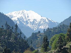
Swat Districtpronounced [ˈswaːt̪]) is a district in Malakand Division of Khyber Pakhtunkhwa province in Pakistan. Swat is renowned for its outstanding natural beauty. Centred upon the upper portions of the Swat River, Swat was a major centre of early Buddhist thought as part of the Gandhara kingdom, and today is littered with ruins from that era. Swat was home to the last isolated pockets of Gandharan Buddhism, which lasted until the 11th century, well after most of the area had converted to Islam. Until 1969, Swat was part of the Yusafzai State of Swat, a self-governing princely state. The region was seized by the Pakistani Taliban in late 2007, and its tourist industry decimated until Pakistani control over Swat was re-established in mid 2009.

Nowshera is the chief city of Nowshera District in the Khyber Pakhtunkhwa Province of Pakistan, and is one of the largest cities in the province.

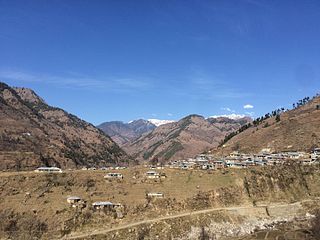
Dir is a region in northwestern Pakistan, in the Khyber Pakhtunkhwa. Lying in the foothills of the Himalayas it has beautiful valleys and scenic mountains. Before Pakistan was created, Dir was a princely state, and it remained so until 1969 when it was abolished by a presidential declaration, with the Dir District being created the following year. Dir District was 5,280 square kilometres in area and lay along the disputed border controlled by the Afghan nationalists. The region is situated between Chitral and Peshawar. In 1996 the district was split into Lower Dir and Upper Dir.
Allai is a tehsil of Batagram District in the Khyber-Pakhtunkhwa province of Pakistan, that also contains the Allai Valley.
The Swat River is a perennial river in the northern region of Khyber-Pakhtunkhwa Province, Pakistan. The river commences in the Kalam Valley of Swat Kohistan with the confluence of two main tributaries Ushu and Utrar and runs downstream in a narrow gorge up to Baghdheri.
Miandam is a hill station in Khyber Pakhtunkhwa, Pakistan, in the foothills of Hindu Kush mountains. It is located at a distance of 55 km away from Mingora the capital of Swat Valley, and 56 kilometers (35 mi) from Saidu Sharif.

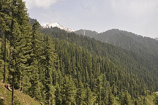
Kalam is a valley located at distance of 99 kilometres (62 mi) from Mingora in the northern upper reaches of Swat valley along the bank of Swat River in Khyber Pakhtunkhwa province of Pakistan. Kalam is surrounded by lush green hills, thick forests and bestowed with mesmeric lakes, meadows and waterfalls which are worth seen features of the landscape. It is the birthplace of Swat river which forms with confluence of two major tributaries of Gabral river and Ushu river.

Kundol Lake also known as Kundol Dand, is a lake in Swat Valley, Khyber Pakhtunkhwa, Pakistan, which is located in the north of Utror valley at a distance of 20.8 kilometres (12.9 mi) away from kalam. Similarly, there is a well known story about the lake which is that every night in a month, a golden bowl appears in the center of the lake and glistens like moon but no one has ever touched that bowl due to magical powers inside it.
Bataira Pain is an administrative unit, known as Union council of Kohistan District in the Khyber Pakhtunkhwa province of Pakistan.
Mada Khelabad is an administrative unit, known as Union council of Kohistan District in the Khyber Pakhtunkhwa province of Pakistan.
Kunshair is an administrative unit, known as Union council of Kohistan District in the Khyber Pakhtunkhwa province of Pakistan.
Haran is an administrative unit, known as Union council of Kohistan District in the Khyber Pakhtunkhwa province of Pakistan.
Dubair Khas is an administrative unit, known as Union council of Kohistan District in the Khyber Pakhtunkhwa province of Pakistan.
Dubair Bala is an administrative unit, known as Union council of Kohistan District in the Khyber Pakhtunkhwa province of Pakistan.
It has many sub localities and Neighborhoods like Mujgali, Dhaar, Dubair Village, Shalki, Sacha and many others out of which Shaikhdara is the most popular locality/ Neighborhood.
District Kohistan has 4 Tehsils i.e. Dassu, Pattan, Palas and Kandian. Each Tehsil comprises a certain number of Union councils. There are 38 Union councils in district Kohistan.
Chowa Dara is an administrative unit, known as Union council of Kohistan District in the Khyber Pakhtunkhwa province of Pakistan.
Kuz Parwa is an administrative unit, known as Union council of Kohistan District in the Khyber Pakhtunkhwa province of Pakistan.

Kumrat is a valley in the Upper Dir District of Khyber Pakhtunkhwa the Province of Pakistan. It is one of the scenic valleys of Khyber Pakhtunkhwa and a picturesque spot for travelers. Every summer season thousands of tourists from different areas of the country visit to Kumrat valley and enjoy the greenery and cool weather.
Kharkhari is a small lake in the Gabral Valley, Pakistan, about 400 m long and 250 m wide. It is traversed by the Gabral river, a tributary of the Utrar River. It is located about 41 km by road from the town of Kalam, 16 km north of the town of Gabrāl and 9 km north of the Gul Bandaj bridge, at an altitude of 5160 meters. The name has also been spelled Karkaray

The Gabral Valley is a valley in the Kohistan District of Khyber Pakhtunkhwa province, Pakistan. It is located in the south slopes of the westernmost end of the Himalayas. Its lower end is at the town of Gabral, about 20 km north from Kalam and 120 km north of Islamabad, at an altitude of 2290 m. The name is also spelled as Gabrāl or Ghabral.